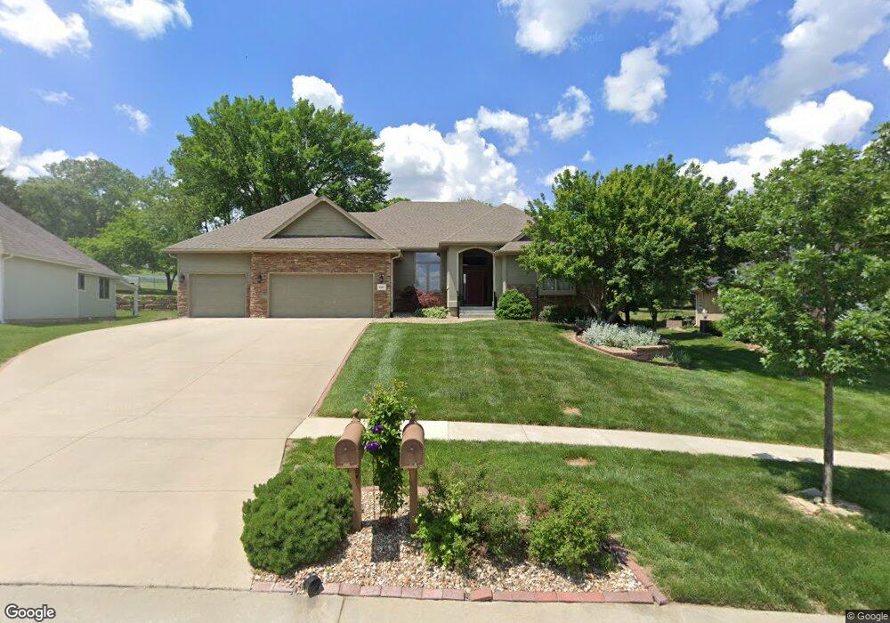
4617 SW Mulligan Dr Topeka, KS 66610
Estimated Value: $381,000 - $446,000
3
Beds
3
Baths
2,886
Sq Ft
$144/Sq Ft
Est. Value
About This Home
This home is located at 4617 SW Mulligan Dr, Topeka, KS 66610 and is currently estimated at $415,440, approximately $143 per square foot. 4617 SW Mulligan Dr is a home located in Shawnee County with nearby schools including Pauline Central Primary School, Pauline South Intermediate School, and Washburn Rural Middle School.
Ownership History
Date
Name
Owned For
Owner Type
Purchase Details
Closed on
Dec 15, 2010
Sold by
Miller Donald D and Miller Georgia A
Bought by
Mcdonald William R and Mcdonald Kathryn A
Current Estimated Value
Purchase Details
Closed on
Jan 15, 2008
Sold by
Lowe R K and R K Lowe Revocable Trust
Bought by
Miller Donald and Miller Georgia A
Create a Home Valuation Report for This Property
The Home Valuation Report is an in-depth analysis detailing your home's value as well as a comparison with similar homes in the area
Home Values in the Area
Average Home Value in this Area
Purchase History
| Date | Buyer | Sale Price | Title Company |
|---|---|---|---|
| Mcdonald William R | -- | Heartlandtitle Services Inc | |
| Miller Donald | -- | Columbian Title Of Topeka |
Source: Public Records
Tax History Compared to Growth
Tax History
| Year | Tax Paid | Tax Assessment Tax Assessment Total Assessment is a certain percentage of the fair market value that is determined by local assessors to be the total taxable value of land and additions on the property. | Land | Improvement |
|---|---|---|---|---|
| 2025 | $7,327 | $47,252 | -- | -- |
| 2023 | $7,327 | $44,976 | $0 | $0 |
| 2022 | $6,482 | $40,158 | $0 | $0 |
| 2021 | $6,003 | $37,419 | $0 | $0 |
| 2020 | $5,607 | $35,638 | $0 | $0 |
| 2019 | $5,345 | $33,940 | $0 | $0 |
| 2018 | $5,173 | $32,951 | $0 | $0 |
| 2017 | $5,132 | $32,305 | $0 | $0 |
| 2014 | $4,987 | $31,050 | $0 | $0 |
Source: Public Records
Map
Nearby Homes
- 4419 SW Stone Ave
- 4313 SW Stone Ave
- 4329 SW Cambridge Ave
- 4229 SW Cambridge Ave
- 3313 SW 46th St
- 3334 SW 43rd St
- 4406 SW Lakeside Dr
- 4334 SW Lakeside Dr
- 3817 SW Wood Valley Dr
- 4498 SW Moundview Dr
- XXXX SW Moundview Dr
- 5515 SW Mission Ave
- 3751 SW Summerfield Dr
- 3638 SW Willow Brook Ct
- 3724 SW Brook Lawn Cir
- 3746 SW Wood Valley Dr
- 3572 SW Willow Brook Dr
- 5614 SW Fairlawn Rd
- 3609 SW Eveningside Dr
- 3513 SW Moundview Dr
- 4621 SW Mulligan Dr
- Lot 24 SW Mulligan Dr
- Lot 2 SW Mulligan Dr
- 4613 SW Mulligan Dr
- 4625 SW Mulligan Dr
- 4609 SW Mulligan Dr
- 4614 SW Mulligan Dr
- 4624 SW Mulligan Dr
- 4604 SW Mulligan Dr
- 4620 SW Gage Blvd
- 4629 SW Mulligan Dr
- 4605 SW Mulligan Dr
- 4630 SW Gage Blvd
- 4634 SW Mulligan Dr
- 4623 SW Moundview Dr
- 4615 SW Moundview Dr
- 4600 SW Mulligan Dr
- 4601 SW Mulligan Dr
- 4633 SW Mulligan Dr
- 4525 SW Moundview Dr