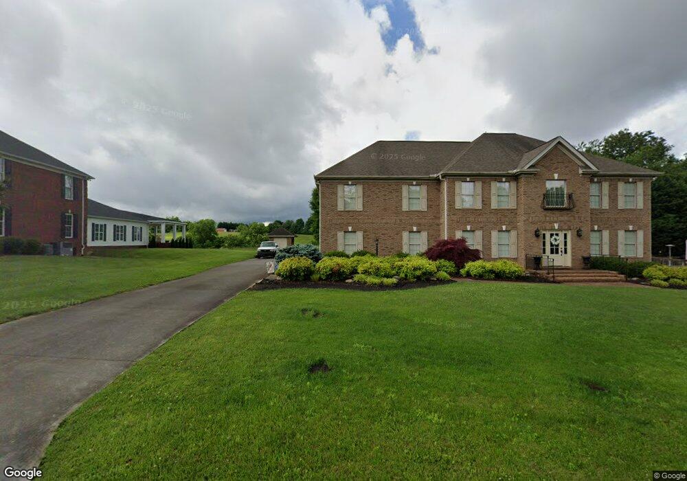
462 Ashland Oaks Dr Morristown, TN 37813
Estimated Value: $472,000 - $774,000
--
Bed
5
Baths
4,944
Sq Ft
$120/Sq Ft
Est. Value
About This Home
This home is located at 462 Ashland Oaks Dr, Morristown, TN 37813 and is currently estimated at $593,455, approximately $120 per square foot. 462 Ashland Oaks Dr is a home located in Hamblen County with nearby schools including Russellville Elementary School, East Ridge Middle School, and Morristown East High School.
Ownership History
Date
Name
Owned For
Owner Type
Purchase Details
Closed on
Feb 25, 2000
Sold by
Young John
Bought by
Allen John R
Current Estimated Value
Purchase Details
Closed on
Apr 15, 1998
Sold by
Fawbush Jack
Bought by
Young John
Purchase Details
Closed on
May 27, 1993
Bought by
Fawbush Jack and Harris Terry
Purchase Details
Closed on
Apr 23, 1992
Bought by
Harrell Bruce F and Harrell Sue J
Purchase Details
Closed on
Aug 17, 1979
Bought by
Harrell Bruce F and Harrell Sue J
Create a Home Valuation Report for This Property
The Home Valuation Report is an in-depth analysis detailing your home's value as well as a comparison with similar homes in the area
Home Values in the Area
Average Home Value in this Area
Purchase History
| Date | Buyer | Sale Price | Title Company |
|---|---|---|---|
| Allen John R | $25,900 | -- | |
| Young John | $19,900 | -- | |
| Fawbush Jack | $119,000 | -- | |
| Harrell Bruce F | -- | -- | |
| Harrell Bruce F | -- | -- |
Source: Public Records
Tax History Compared to Growth
Tax History
| Year | Tax Paid | Tax Assessment Tax Assessment Total Assessment is a certain percentage of the fair market value that is determined by local assessors to be the total taxable value of land and additions on the property. | Land | Improvement |
|---|---|---|---|---|
| 2024 | $1,937 | $110,075 | $7,800 | $102,275 |
| 2023 | $1,937 | $110,075 | $0 | $0 |
| 2022 | $3,478 | $110,075 | $7,800 | $102,275 |
| 2021 | $3,478 | $110,075 | $7,800 | $102,275 |
| 2020 | $3,473 | $110,075 | $7,800 | $102,275 |
| 2019 | $3,500 | $102,925 | $6,775 | $96,150 |
| 2018 | $3,243 | $102,925 | $6,775 | $96,150 |
| 2017 | $3,191 | $102,925 | $6,775 | $96,150 |
| 2016 | $3,046 | $102,925 | $6,775 | $96,150 |
| 2015 | $2,835 | $102,925 | $6,775 | $96,150 |
| 2014 | -- | $102,925 | $6,775 | $96,150 |
| 2013 | -- | $112,925 | $0 | $0 |
Source: Public Records
Map
Nearby Homes
- 288 Fuller Estate Cir
- 576 Jones-Franklin Rd
- 4458 Brockland Dr
- 4907 Barton Springs Dr
- 4270 Brockland Dr
- 670 Jones Franklin Rd
- 4705 E Hampton Blvd
- 4581 Lockley Ct
- 1148 George Byrd Rd
- 4027 White Wood Cir
- 1134 Shannons Little Mountain Rd
- 3661 Halifax Cir
- 5085 Old Kentucky Rd
- 354 Volunteer Dr
- 1438 Shannons Little Mtn Rd
- 00 Shinbone E Sugar Hollow Rd
- 1689 Carroll Rd
- 466 Ashland Oaks Dr
- 452 Ashland Oaks Dr
- 470 Ashland Oaks Dr
- 465 Ashland Oaks Dr
- 432 Ashland Oaks Dr
- 5009 Paw Paw Ct
- 476 Ashland Oaks Dr
- 473 Ashland Oaks Dr
- 5002 Woodbury Ct
- 5010 Paw Paw Ct
- 422 Ashland Oaks Dr
- 484 Ashland Oaks Dr
- 5005 Woodbine St
- 4930 Hundred Oaks Dr
- 5012 Woodbury Ct
- 421 Ashland Oaks Dr
- 4920 Hundred Oaks Dr
- 5019 Paw Ct
- 5019 Paw Paw Ct
- 4950 Hundred Oaks Dr