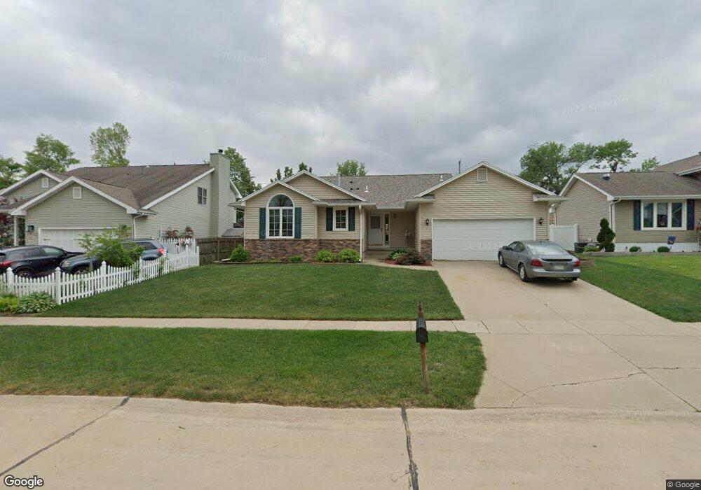
4621 Pearl Ave NW Cedar Rapids, IA 52405
Cherry Hill Park NeighborhoodEstimated Value: $244,000 - $291,000
3
Beds
2
Baths
1,509
Sq Ft
$174/Sq Ft
Est. Value
About This Home
This home is located at 4621 Pearl Ave NW, Cedar Rapids, IA 52405 and is currently estimated at $262,499, approximately $173 per square foot. 4621 Pearl Ave NW is a home located in Linn County with nearby schools including Junction City Elementary School, Hoover Elementary School, and Kentucky Tech - Ashland Reg Tech Center.
Ownership History
Date
Name
Owned For
Owner Type
Purchase Details
Closed on
Mar 24, 2010
Sold by
Dawson Lori L
Bought by
Dawson Edward P
Current Estimated Value
Create a Home Valuation Report for This Property
The Home Valuation Report is an in-depth analysis detailing your home's value as well as a comparison with similar homes in the area
Home Values in the Area
Average Home Value in this Area
Purchase History
| Date | Buyer | Sale Price | Title Company |
|---|---|---|---|
| Dawson Edward P | -- | None Available |
Source: Public Records
Tax History Compared to Growth
Tax History
| Year | Tax Paid | Tax Assessment Tax Assessment Total Assessment is a certain percentage of the fair market value that is determined by local assessors to be the total taxable value of land and additions on the property. | Land | Improvement |
|---|---|---|---|---|
| 2025 | $3,776 | $271,900 | $44,100 | $227,800 |
| 2024 | $4,276 | $257,400 | $44,100 | $213,300 |
| 2023 | $4,276 | $232,500 | $44,100 | $188,400 |
| 2022 | $4,290 | $215,000 | $39,400 | $175,600 |
| 2021 | $4,426 | $219,500 | $34,700 | $184,800 |
| 2020 | $4,426 | $212,500 | $34,700 | $177,800 |
| 2019 | $4,122 | $203,000 | $25,200 | $177,800 |
| 2018 | $4,002 | $203,000 | $25,200 | $177,800 |
| 2017 | $4,040 | $197,300 | $25,200 | $172,100 |
| 2016 | $4,023 | $192,600 | $25,200 | $167,400 |
| 2015 | $3,877 | $185,515 | $28,373 | $157,142 |
| 2014 | $3,692 | $177,812 | $28,373 | $149,439 |
| 2013 | $3,446 | $177,812 | $28,373 | $149,439 |
Source: Public Records
Map
Nearby Homes
- 4819 Ford Ave NW
- 272 Peace Ave NW
- 208 Lenora Dr NW
- 281 Jacolyn Dr NW
- 229 Jacolyn Dr NW
- 4975 Kesler Rd NW
- 4910 Gordon Ave NW
- 5127 Holly Ave NW
- 4819 Fruitwood Ln NW
- 150 Meadowlark Ln NW
- 106 Leroy St NW
- 4622 1st Ave NW Unit E
- 3600 Midway Dr NW
- 4619 1st Ave SW Unit 3
- 56 Julia Ann Dr NW
- 5530 Skyline Dr NW
- 3509 E Ave NW Unit D
- 3507 E Ave NW Unit F
- 164 Cherry Hill Rd NW
- 5720 Gordon Ave NW
- 4613 Pearl Ave NW
- 4629 Pearl Ave NW
- 4630 Midway Dr NW
- 4640 Midway Dr NW
- 4620 Midway Dr NW
- 4637 Pearl Ave NW
- 4605 Pearl Ave NW
- 4650 Midway Dr NW
- 4610 Midway Dr NW
- 4622 Pearl Ave NW
- 4703 Pearl Ave NW
- 4630 Pearl Ave NW
- 4525 Pearl Ave NW
- 4700 Midway Dr NW
- 4600 Midway Dr NW
- 4614 Pearl Ave NW
- 4606 Pearl Ave NW
- 4700 Pearl Ave NW
- 4711 Pearl Ave NW
- 4520 Pearl Ave NW