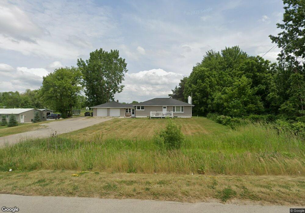
4625 Division St Wayland, MI 49348
Estimated Value: $317,000 - $442,000
3
Beds
2
Baths
1,260
Sq Ft
$289/Sq Ft
Est. Value
About This Home
This home is located at 4625 Division St, Wayland, MI 49348 and is currently estimated at $364,061, approximately $288 per square foot. 4625 Division St is a home located in Allegan County with nearby schools including Wayland High School, Byron Center Charter School, and Moline Christian School.
Ownership History
Date
Name
Owned For
Owner Type
Purchase Details
Closed on
Jun 15, 2016
Sold by
Rookus John and John Rookus Trust #1
Bought by
Johnston Enterprise Llc
Current Estimated Value
Purchase Details
Closed on
Dec 28, 2004
Sold by
Rookus John
Bought by
Rookus John and John Rookus Trust #1
Purchase Details
Closed on
Mar 17, 2001
Sold by
Rookus Young Contractors Inc
Bought by
Rookus John
Purchase Details
Closed on
Mar 18, 1998
Sold by
Mosher Bev and Carpenter Marcia
Bought by
Martin William and Rookus John
Purchase Details
Closed on
Jul 23, 1997
Sold by
Tornga Siebrand
Bought by
Tornga Siebrand
Purchase Details
Closed on
Jan 1, 1997
Sold by
Tornga Siebrand
Create a Home Valuation Report for This Property
The Home Valuation Report is an in-depth analysis detailing your home's value as well as a comparison with similar homes in the area
Home Values in the Area
Average Home Value in this Area
Purchase History
| Date | Buyer | Sale Price | Title Company |
|---|---|---|---|
| Johnston Enterprise Llc | $170,000 | First American Title Ins Co | |
| Rookus John | -- | -- | |
| Rookus John | $40,000 | -- | |
| Martin William | $40,000 | -- | |
| Martin William | $103,000 | -- | |
| Tornga Siebrand | -- | -- | |
| -- | -- | -- | |
| -- | -- | -- |
Source: Public Records
Tax History Compared to Growth
Tax History
| Year | Tax Paid | Tax Assessment Tax Assessment Total Assessment is a certain percentage of the fair market value that is determined by local assessors to be the total taxable value of land and additions on the property. | Land | Improvement |
|---|---|---|---|---|
| 2025 | $4,744 | $135,500 | $29,000 | $106,500 |
| 2024 | $4,310 | $130,900 | $25,500 | $105,400 |
| 2023 | $4,310 | $116,600 | $25,500 | $91,100 |
| 2022 | $4,310 | $104,900 | $25,500 | $79,400 |
| 2021 | $4,077 | $98,000 | $25,500 | $72,500 |
| 2020 | $4,030 | $92,500 | $25,500 | $67,000 |
| 2019 | $3,927 | $84,200 | $24,300 | $59,900 |
| 2018 | $3,817 | $80,100 | $24,300 | $55,800 |
| 2017 | $0 | $77,600 | $24,300 | $53,300 |
| 2016 | $0 | $61,300 | $24,300 | $37,000 |
| 2015 | -- | $61,300 | $24,300 | $37,000 |
| 2014 | -- | $55,600 | $22,300 | $33,300 |
| 2013 | $2,958 | $52,900 | $22,300 | $30,600 |
Source: Public Records
Map
Nearby Homes
- 4351 Hickory View Ct
- 4335 Tavistock Dr
- 4653 Leighton Lakes Dr Unit 9
- 4316 Sussex Place
- 1069 108th St SW
- Lot 11 Walnut Dale Dr
- 4273 Highpoint Dr Unit 112
- Unit 111 Highpoint Dr
- 82 100th St SW
- 82 100th St SW
- 92 100th St SW
- 112 100th St SW
- 4274 Butternut Dr
- Lot 142 Butternut Dr
- Lot 141 Butternut Dr
- 4249 Butternut Dr
- 4245 Butternut Dr
- 4240 Butternut Dr
- Vienna Plan at Harvest Meadows
- Charlotte Plan at Harvest Meadows
- 4625 Division St
- 4617 Division St
- 4617 Division Ave S
- 4609 Division St
- 4609 Division St
- 4647 Division St
- 4649 Division St
- 4651 Division St
- 4651 12th St
- 1195 146th Ave
- 1185 146th Ave
- 1201 146th Ave
- 0 146th Ave Unit M18054275
- 0 146th Ave Unit M19049847
- 0 146th Ave Unit M20039351
- 7 146th Ave
- 0 146th Ave Unit APP 8 3317963
- 1222 Ingle Rd
- 4614 12th St
- 4655 12th St