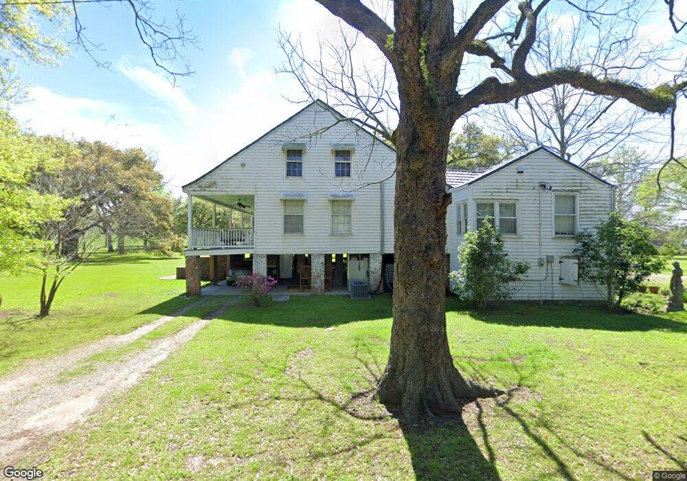
4626 S River Rd Port Allen, LA 70767
West Baton Rouge Parish NeighborhoodEstimated Value: $515,000 - $726,000
4
Beds
2
Baths
2,980
Sq Ft
$210/Sq Ft
Est. Value
About This Home
This home is located at 4626 S River Rd, Port Allen, LA 70767 and is currently estimated at $625,309, approximately $209 per square foot. 4626 S River Rd is a home located in West Baton Rouge Parish with nearby schools including Brusly Elementary School, Lukeville Upper Elementary School, and Brusly Middle School.
Ownership History
Date
Name
Owned For
Owner Type
Purchase Details
Closed on
Jun 1, 2007
Sold by
Estate Of Edward Anthony Blanchard
Bought by
Becnel Michael Ernest and Becnel Jan Gautreau
Current Estimated Value
Create a Home Valuation Report for This Property
The Home Valuation Report is an in-depth analysis detailing your home's value as well as a comparison with similar homes in the area
Home Values in the Area
Average Home Value in this Area
Purchase History
| Date | Buyer | Sale Price | Title Company |
|---|---|---|---|
| Becnel Michael Ernest | $499,000 | None Available |
Source: Public Records
Tax History Compared to Growth
Tax History
| Year | Tax Paid | Tax Assessment Tax Assessment Total Assessment is a certain percentage of the fair market value that is determined by local assessors to be the total taxable value of land and additions on the property. | Land | Improvement |
|---|---|---|---|---|
| 2024 | $4,606 | $55,050 | $9,500 | $45,550 |
| 2023 | $3,850 | $44,580 | $7,800 | $36,780 |
| 2022 | $4,676 | $44,580 | $7,800 | $36,780 |
| 2021 | $4,781 | $44,580 | $7,800 | $36,780 |
| 2020 | $4,346 | $40,120 | $7,020 | $33,100 |
| 2019 | $4,681 | $41,490 | $10,280 | $31,210 |
| 2018 | $4,766 | $41,490 | $10,280 | $31,210 |
| 2017 | $4,401 | $41,490 | $10,280 | $31,210 |
| 2015 | $3,521 | $41,000 | $9,790 | $31,210 |
| 2014 | $3,464 | $41,000 | $9,790 | $31,210 |
| 2013 | $1,313 | $15,540 | $9,790 | $5,750 |
Source: Public Records
Map
Nearby Homes
- 1959 Fairview Ave
- 4747 Evergreen Dr
- 2218 Silverstone Ave
- 2217 Silverstone Ave
- 1394 Rue Riviere
- 1152 Freeman Ln
- 2742 Emily Dr
- 2488 Oak Alley Dr
- 4000 Lake Beau Pre Blvd Unit 110
- 4000 Lake Beau Pre Blvd Unit 198
- 3926 Northshore Ave
- 5565 Ducros Dr
- 5024 Myrtle Trail Dr
- 526 Gwin St
- 6455 Louisiana 1
- 6312 Louisiana 1
- 3822 Southpass Ave
- 3839 Southpass Ave
- 540 Bourgeois St
- 5129 Amberlyn Dr
- 1734 Antonio Rd
- 1734 Antonia
- 4616 S River Rd
- 1724 Antonio Rd
- 1744 Antonio Rd
- 1827 Antonio Rd
- 1738 Antonio Rd
- 4569 S River Rd
- 1826 Antonio Rd
- 1847 Antonio Rd
- 4734 S River Rd
- 1846 Antonio Rd
- 1810 Auguste St
- 4744 S River Rd
- 4513 Robin St
- 4549 S River Rd
- 1820 Auguste St
- 1877 Antonio Rd
- 1815 Auguste St
- 4760 S River Rd