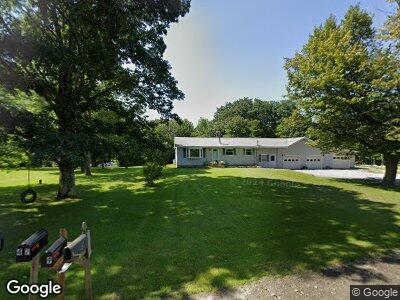
463 Huntington Hill Rd Litchfield, ME 04350
Estimated Value: $314,539 - $443,000
--
Bed
--
Bath
1,480
Sq Ft
$259/Sq Ft
Est. Value
About This Home
This home is located at 463 Huntington Hill Rd, Litchfield, ME 04350 and is currently estimated at $383,635, approximately $259 per square foot. 463 Huntington Hill Rd is a home located in Kennebec County with nearby schools including Libby-Tozier School, Sabattus Primary School, and Carrie Ricker School.
Ownership History
Date
Name
Owned For
Owner Type
Purchase Details
Closed on
Jul 3, 2024
Sold by
Rolston Robert G and Rolston Sheila E
Bought by
Rolston
Current Estimated Value
Create a Home Valuation Report for This Property
The Home Valuation Report is an in-depth analysis detailing your home's value as well as a comparison with similar homes in the area
Home Values in the Area
Average Home Value in this Area
Purchase History
| Date | Buyer | Sale Price | Title Company |
|---|---|---|---|
| Rolston | -- | None Available | |
| Rolston | -- | None Available | |
| Rolston | -- | None Available |
Source: Public Records
Mortgage History
| Date | Status | Borrower | Loan Amount |
|---|---|---|---|
| Previous Owner | Rolston Robert G | $100,000 | |
| Previous Owner | Rolston Robert | $50,000 | |
| Previous Owner | Rolston Robert | $20,000 | |
| Previous Owner | Rolston Robert G | $10,000 | |
| Previous Owner | Rolston Robert G | $97,000 | |
| Previous Owner | Rolston Shelia | $40,000 |
Source: Public Records
Tax History Compared to Growth
Tax History
| Year | Tax Paid | Tax Assessment Tax Assessment Total Assessment is a certain percentage of the fair market value that is determined by local assessors to be the total taxable value of land and additions on the property. | Land | Improvement |
|---|---|---|---|---|
| 2024 | $3,315 | $232,600 | $56,900 | $175,700 |
| 2023 | $3,140 | $232,600 | $56,900 | $175,700 |
| 2022 | $3,050 | $194,000 | $47,400 | $146,600 |
| 2021 | $2,741 | $194,000 | $47,400 | $146,600 |
| 2020 | $2,755 | $194,000 | $47,400 | $146,600 |
| 2019 | $2,716 | $194,000 | $47,400 | $146,600 |
| 2018 | $2,535 | $156,964 | $42,000 | $114,964 |
| 2017 | $2,555 | $158,227 | $42,000 | $116,227 |
| 2016 | $2,560 | $158,519 | $42,000 | $116,519 |
| 2015 | $2,485 | $159,785 | $42,000 | $117,785 |
| 2014 | $2,277 | $159,785 | $42,000 | $117,785 |
| 2013 | $1,984 | $161,341 | $42,000 | $119,341 |
Source: Public Records
Map
Nearby Homes
- 51 Forest Ln
- Lot 13A Ridley Ln
- 20 Lucien Ln
- 75 Grant Rd
- 57 Nutting Ln
- 2793 Hallowell Rd
- 64 Ferrin Rd
- 1-70 Maine 197
- 69 Scott Dr
- 0 Rd Unit 1590643
- 0 Route 9-126 Litchfield Dr Unit 1604469
- 0 Academy Rd Unit 1502594
- 47 Fickett Dr
- 17 Brookwood Ln
- 8 Maxwell Rd
- 543 Dead River Rd
- 86-A Kenway Dr
- 12 Cattail Ln
- 73 Spring Dr
- 2 Warren Rd
- 463 Huntington Hill Rd
- 471 Huntington Hill Rd
- 9 Thornton Ln
- 456 Huntington Hill Rd
- 10 Vida Ln
- 448 Huntington Hill Rd
- 480 Huntington Hill Rd
- 18 Thornton Ln
- 27 Thornton Ln
- 490 Huntington Hill Rd
- 438 Huntington Hill Rd
- 433 Huntington Hill Rd
- 8 Riley Ridge Rd
- 500 Huntington Hill Rd
- 15 Lois Ln
- 34 Thornton Ln
- 47 Thornton Ln
- 49 Vida Ln
- 0 Thornton Ln
- 525 Huntington Hill Rd