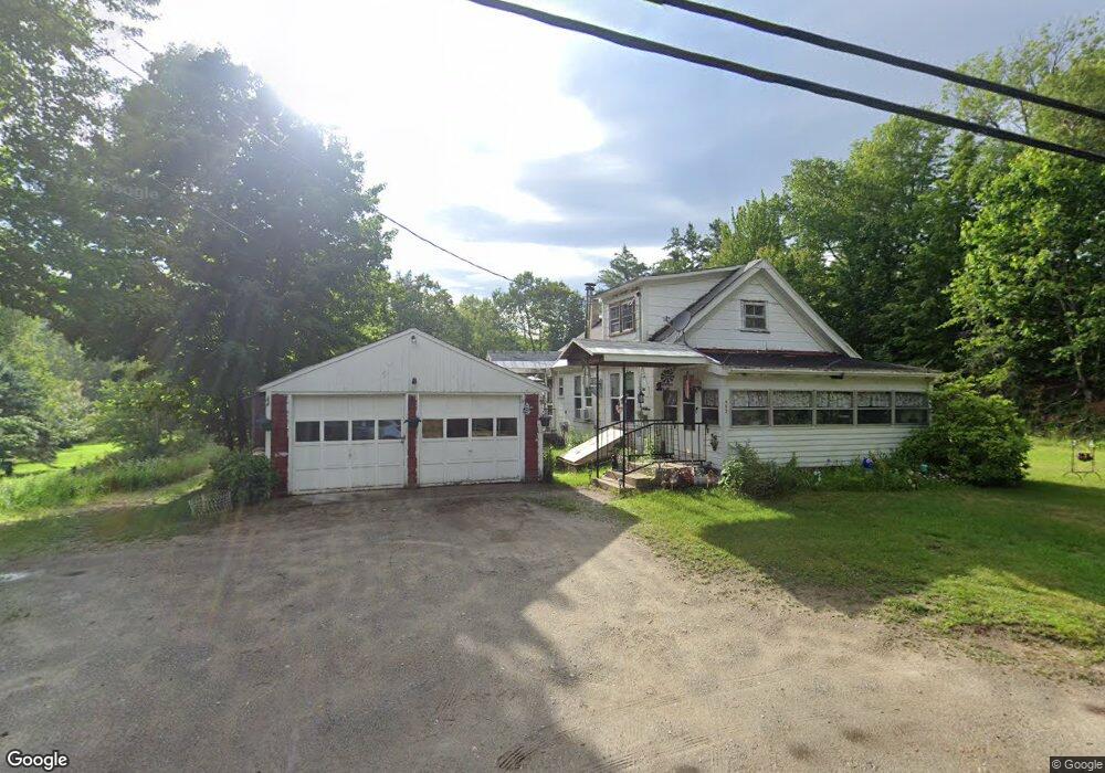
463 Unity Rd Newport, NH 03773
Estimated Value: $208,000 - $348,000
3
Beds
1
Bath
1,377
Sq Ft
$205/Sq Ft
Est. Value
About This Home
This home is located at 463 Unity Rd, Newport, NH 03773 and is currently estimated at $282,771, approximately $205 per square foot. 463 Unity Rd is a home located in Sullivan County with nearby schools including Richards Elementary School, Newport High School, and Newport Montessori School.
Ownership History
Date
Name
Owned For
Owner Type
Purchase Details
Closed on
May 31, 2007
Sold by
Willey Randy
Bought by
Gosselin Richard J and Gosselin Peggy A
Current Estimated Value
Home Financials for this Owner
Home Financials are based on the most recent Mortgage that was taken out on this home.
Original Mortgage
$107,910
Outstanding Balance
$64,266
Interest Rate
6.24%
Mortgage Type
Purchase Money Mortgage
Estimated Equity
$218,505
Purchase Details
Closed on
May 6, 1997
Sold by
Hastings Louise K
Bought by
Laclair David W and Laclair Angela H
Home Financials for this Owner
Home Financials are based on the most recent Mortgage that was taken out on this home.
Original Mortgage
$34,450
Interest Rate
7.85%
Create a Home Valuation Report for This Property
The Home Valuation Report is an in-depth analysis detailing your home's value as well as a comparison with similar homes in the area
Home Values in the Area
Average Home Value in this Area
Purchase History
| Date | Buyer | Sale Price | Title Company |
|---|---|---|---|
| Gosselin Richard J | $119,900 | -- | |
| Laclair David W | $53,000 | -- |
Source: Public Records
Mortgage History
| Date | Status | Borrower | Loan Amount |
|---|---|---|---|
| Open | Laclair David W | $107,910 | |
| Previous Owner | Laclair David W | $34,450 |
Source: Public Records
Tax History
| Year | Tax Paid | Tax Assessment Tax Assessment Total Assessment is a certain percentage of the fair market value that is determined by local assessors to be the total taxable value of land and additions on the property. | Land | Improvement |
|---|---|---|---|---|
| 2025 | $3,974 | $158,400 | $71,100 | $87,300 |
| 2024 | $3,851 | $158,400 | $71,100 | $87,300 |
| 2023 | $3,735 | $158,400 | $71,100 | $87,300 |
| 2022 | $3,311 | $158,400 | $71,100 | $87,300 |
| 2021 | $3,336 | $101,100 | $48,000 | $53,100 |
| 2020 | $3,346 | $101,100 | $48,000 | $53,100 |
| 2019 | $3,302 | $101,500 | $48,000 | $53,500 |
| 2018 | $2,994 | $98,500 | $48,000 | $50,500 |
| 2017 | $2,959 | $98,500 | $48,000 | $50,500 |
| 2016 | $2,758 | $96,000 | $45,600 | $50,400 |
| 2015 | $2,808 | $96,000 | $45,600 | $50,400 |
| 2014 | $3,037 | $96,000 | $45,600 | $50,400 |
| 2013 | $2,879 | $96,000 | $45,600 | $50,400 |
Source: Public Records
Map
Nearby Homes
- 27 People Way Unit 27
- 4 River View Rd
- Lot 18 River View Rd
- 44 Brook View Rd
- 45 Brook View Rd
- 33 Brook View Rd
- 32 Brook View Rd
- 27 Brook View Rd
- 43 Brook View Rd
- 29 Brook View Rd
- 31 Brook View Rd
- 34 Brook View Rd
- 36 Brook View Rd
- 37 Brook View Rd
- 39 Brook View Rd
- Lot 46 Brook View Rd
- 26 Brook View Rd
- 40 Brook View Rd
- 42 Brook View Rd
- 35 Brook View Rd
Your Personal Tour Guide
Ask me questions while you tour the home.