Estimated Value: $207,000 - $261,000
3
Beds
2
Baths
2,032
Sq Ft
$115/Sq Ft
Est. Value
About This Home
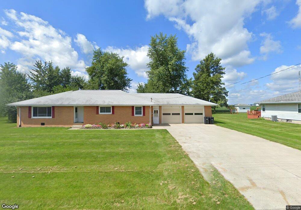
This home is located at 4635 N Cable Rd, Lima, OH 45807 and is currently estimated at $232,678, approximately $114 per square foot. 4635 N Cable Rd is a home located in Allen County with nearby schools including Elida Elementary School, Elida Middle School, and Elida High School.
Ownership History
Date
Name
Owned For
Owner Type
Purchase Details
Closed on
Nov 13, 2020
Sold by
Jones Trista M and Duff Trista M
Bought by
Duff Trista M and Duff Adam E
Current Estimated Value
Home Financials for this Owner
Home Financials are based on the most recent Mortgage that was taken out on this home.
Original Mortgage
$81,700
Outstanding Balance
$59,013
Interest Rate
2.8%
Mortgage Type
New Conventional
Estimated Equity
$173,665
Purchase Details
Closed on
Mar 16, 2011
Sold by
Smith John W and Karolyi Carolyn
Bought by
Jones Trista M
Home Financials for this Owner
Home Financials are based on the most recent Mortgage that was taken out on this home.
Original Mortgage
$94,559
Interest Rate
5.09%
Mortgage Type
New Conventional
Purchase Details
Closed on
Aug 28, 1987
Bought by
Smith John W
Create a Home Valuation Report for This Property
The Home Valuation Report is an in-depth analysis detailing your home's value as well as a comparison with similar homes in the area
Purchase History
| Date | Buyer | Sale Price | Title Company |
|---|---|---|---|
| Duff Trista M | -- | None Available | |
| Jones Trista M | $91,300 | Accu Title Agency | |
| Smith John W | $54,000 | -- |
Source: Public Records
Mortgage History
| Date | Status | Borrower | Loan Amount |
|---|---|---|---|
| Open | Duff Trista M | $81,700 | |
| Closed | Jones Trista M | $94,559 |
Source: Public Records
Tax History
| Year | Tax Paid | Tax Assessment Tax Assessment Total Assessment is a certain percentage of the fair market value that is determined by local assessors to be the total taxable value of land and additions on the property. | Land | Improvement |
|---|---|---|---|---|
| 2024 | $2,294 | $57,580 | $7,560 | $50,020 |
| 2023 | $1,823 | $41,130 | $5,390 | $35,740 |
| 2022 | $1,861 | $41,130 | $5,390 | $35,740 |
| 2021 | $1,872 | $41,130 | $5,390 | $35,740 |
| 2020 | $1,844 | $38,190 | $4,870 | $33,320 |
| 2019 | $1,844 | $38,190 | $4,870 | $33,320 |
| 2018 | $1,686 | $38,190 | $4,870 | $33,320 |
| 2017 | $1,503 | $32,630 | $4,870 | $27,760 |
| 2016 | $1,506 | $32,630 | $4,870 | $27,760 |
| 2015 | $1,689 | $32,630 | $4,870 | $27,760 |
| 2014 | $1,689 | $34,940 | $4,660 | $30,280 |
| 2013 | $1,638 | $34,940 | $4,660 | $30,280 |
Source: Public Records
Map
Nearby Homes
- 0 Fraunfelter Unit 307817
- 0 N Eastown Rd Unit 1034495
- 0000 Diller Rd
- 4250 Diller Rd
- 715 Wildwood Ave
- 1743 Sherry Lee Dr
- 2718 Carolyn Dr
- 2630 Carolyn Dr
- 114 Roger St
- 2275 N Cable Rd Unit 178
- 2275 N Cable Rd Unit 130
- 2275 N Cable Rd Unit 43 Unit Package
- 2275 N Cable Rd Unit 42
- 2275 N Cable Rd Unit 12
- 2275 N Cable Rd Unit 24
- 2275 N Cable Rd Unit 1
- 2275 N Cable Rd
- 2275 N Cable Rd Unit 97
- 2275 N Cable Rd Unit 137
- 2275 N Cable Rd Unit 6
- 4657 N Cable Rd
- 4625 N Cable Rd
- 4581 N Cable Rd
- 2800 Irvin Rd
- 2828 Irvin Rd
- 2760 Irvin Rd
- 2710 Irvin Rd
- 2650 Irvin Rd
- 4882 N Cable Rd
- 1693 Irvin Rd
- 0 Irvin Rd
- 2584 Irvin Rd
- 2540 Irvin Rd
- 2470 Irvin Rd
- 4690 Sandy Point Rd
- 2340 Irvin Rd
- 4599 Sandy Point Rd
- 4701 Sandy Point Rd
- 4645 Sandy Point Rd
- 4210 N Cable Rd
Your Personal Tour Guide
Ask me questions while you tour the home.