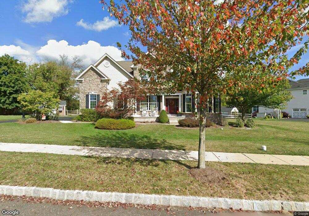
4635 Strouse Ln Doylestown, PA 18902
Plumstead NeighborhoodEstimated Value: $1,007,451 - $1,279,000
4
Beds
4
Baths
3,675
Sq Ft
$307/Sq Ft
Est. Value
About This Home
This home is located at 4635 Strouse Ln, Doylestown, PA 18902 and is currently estimated at $1,126,613, approximately $306 per square foot. 4635 Strouse Ln is a home with nearby schools including Gayman Elementary School, Tohickon Middle School, and Central Bucks High School - East.
Ownership History
Date
Name
Owned For
Owner Type
Purchase Details
Closed on
Aug 31, 2012
Sold by
Toll Pa Viii Lp
Bought by
Reich Christopher D and Reich Christina
Current Estimated Value
Home Financials for this Owner
Home Financials are based on the most recent Mortgage that was taken out on this home.
Original Mortgage
$71,672
Outstanding Balance
$49,594
Interest Rate
3.57%
Mortgage Type
Credit Line Revolving
Estimated Equity
$1,077,019
Create a Home Valuation Report for This Property
The Home Valuation Report is an in-depth analysis detailing your home's value as well as a comparison with similar homes in the area
Home Values in the Area
Average Home Value in this Area
Purchase History
| Date | Buyer | Sale Price | Title Company |
|---|---|---|---|
| Reich Christopher D | $635,190 | None Available |
Source: Public Records
Mortgage History
| Date | Status | Borrower | Loan Amount |
|---|---|---|---|
| Open | Reich Christopher D | $71,672 | |
| Open | Reich Christopher D | $417,000 |
Source: Public Records
Tax History
| Year | Tax Paid | Tax Assessment Tax Assessment Total Assessment is a certain percentage of the fair market value that is determined by local assessors to be the total taxable value of land and additions on the property. | Land | Improvement |
|---|---|---|---|---|
| 2025 | $11,926 | $68,640 | $6,580 | $62,060 |
| 2024 | $11,926 | $68,640 | $6,580 | $62,060 |
| 2023 | $11,547 | $68,640 | $6,580 | $62,060 |
| 2022 | $11,418 | $68,640 | $6,580 | $62,060 |
| 2021 | $11,291 | $68,640 | $6,580 | $62,060 |
| 2020 | $11,291 | $68,640 | $6,580 | $62,060 |
| 2019 | $11,222 | $68,640 | $6,580 | $62,060 |
| 2018 | $11,222 | $68,640 | $6,580 | $62,060 |
| 2017 | $11,068 | $68,640 | $6,580 | $62,060 |
| 2016 | $11,068 | $68,640 | $6,580 | $62,060 |
| 2015 | -- | $68,640 | $6,580 | $62,060 |
| 2014 | -- | $68,640 | $6,580 | $62,060 |
Source: Public Records
Map
Nearby Homes
- 6680 Point Pleasant Pike
- 5182 Point Pleasant Pike
- 5805 Ridgeview Dr
- 5829 Ridgeview Dr
- 5730 Carversville Rd
- 4964 Point Pleasant Pike
- 5987 Point Pleasant Pike
- 4925 Redfield Rd
- 5491 Long Ln
- 4848 Tall Oak Ct
- 6163 Carversville Rd
- 5529 Geddes Way
- 6169 Carversville Rd
- 4936 Curly Hill Rd
- 4533 Deep Creek Way
- 4190 Milords Ln
- 0 Old Durham Rd
- 3468 Holicong Rd
- 5382 Wismer Rd
- 4525 Deep Glen Way
- 4625 Strouse Ln
- 4632 Strousse Ln
- 4628 Strouse Ln
- 4619 Strouse Ln
- 4624 Strouse Ln
- 4613 Strouse Ln
- 4616 Strouse Ln
- 4610 Strouse Ln
- 4607 Strouse Ln
- 4604 Strouse Ln
- 5700 Twin Silo Rd
- 4601 Strouse Ln
- 5429 Preston Way
- 4598 Strouse Ln
- 5433 Preston Way
- 4595 Strouse Ln
- 4592 Strouse Ln
- 5428 Preston Way
- 5437 Preston Way
- 4589 Strouse Ln