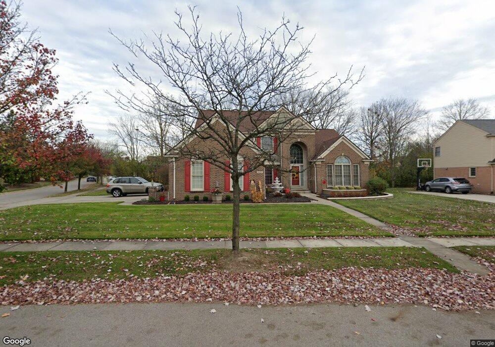
46403 Inverness Rd Canton, MI 48188
Estimated Value: $631,000 - $679,000
Studio
3
Baths
2,964
Sq Ft
$218/Sq Ft
Est. Value
About This Home
This home is located at 46403 Inverness Rd, Canton, MI 48188 and is currently estimated at $647,190, approximately $218 per square foot. 46403 Inverness Rd is a home located in Wayne County with nearby schools including Canton High School, Plymouth High School, and Salem High School.
Ownership History
Date
Name
Owned For
Owner Type
Purchase Details
Closed on
Jul 7, 2007
Sold by
Bonner Robert H and Bonner Michelle T
Bought by
Smith Ransom
Current Estimated Value
Home Financials for this Owner
Home Financials are based on the most recent Mortgage that was taken out on this home.
Original Mortgage
$302,400
Outstanding Balance
$191,269
Interest Rate
6.73%
Mortgage Type
Purchase Money Mortgage
Estimated Equity
$455,921
Create a Home Valuation Report for This Property
The Home Valuation Report is an in-depth analysis detailing your home's value as well as a comparison with similar homes in the area
Home Values in the Area
Average Home Value in this Area
Purchase History
| Date | Buyer | Sale Price | Title Company |
|---|---|---|---|
| Smith Ransom | $336,000 | Fidelity National Title |
Source: Public Records
Mortgage History
| Date | Status | Borrower | Loan Amount |
|---|---|---|---|
| Open | Smith Ransom | $302,400 |
Source: Public Records
Tax History
| Year | Tax Paid | Tax Assessment Tax Assessment Total Assessment is a certain percentage of the fair market value that is determined by local assessors to be the total taxable value of land and additions on the property. | Land | Improvement |
|---|---|---|---|---|
| 2025 | $4,170 | $339,800 | $0 | $0 |
| 2024 | $4,051 | $294,200 | $0 | $0 |
| 2023 | $3,824 | $281,700 | $0 | $0 |
| 2022 | $8,242 | $250,500 | $0 | $0 |
| 2021 | $7,234 | $230,300 | $0 | $0 |
| 2020 | $7,146 | $222,300 | $0 | $0 |
| 2019 | $7,013 | $197,550 | $0 | $0 |
| 2018 | $2,935 | $185,890 | $0 | $0 |
| 2017 | $7,055 | $182,800 | $0 | $0 |
| 2016 | $6,369 | $184,600 | $0 | $0 |
| 2015 | $16,124 | $163,430 | $0 | $0 |
| 2013 | $15,620 | $167,880 | $0 | $0 |
| 2010 | -- | $146,000 | $74,856 | $71,144 |
Source: Public Records
Map
Nearby Homes
- 51083 Meadowlands
- 45246 Gerald Ct
- 45863 Baywood Blvd
- 215 Edington Cir
- 45169 Middlebury Ln
- 407 Fairfield Ct
- 1752 Thistle Dr
- 464 Waterview Ct
- 46501 Killarney Cir
- 241 Edington Cir
- 8517 N Beck Rd
- 48030 Cherry Hill Rd
- 47450 Ellery Ln
- 45678 Aragon Ln
- 1244 W Crystal Cir
- 1289 Old Colony Ln Unit 232
- 1276 W Crystal Cir Unit 202
- 1275 Hendrie
- 1849 Wentworth Ct
- 48318 Manhattan Cir
- 46425 Inverness Rd
- 45555 Glengarry Blvd
- 46491 Glengarry Blvd Unit Bldg-Unit
- 46491 Glengarry Blvd
- 45554 Muirfield Ct
- 46451 Inverness Rd
- 45550 Muirfield Ct
- 45547 Glengarry Blvd
- 46446 Glengarry Blvd
- 46430 Inverness Rd
- 46400 Glengarry Blvd
- 46488 Glengarry Blvd
- 45546 Muirfield Ct
- 46553 Glengarry Blvd
- 46475 Inverness Rd
- 46462 Inverness Rd
- 45543 Glengarry Blvd
- 45548 Glengarry Blvd
- 46530 Glengarry Blvd
- 45551 Muirfield Ct
Your Personal Tour Guide
Ask me questions while you tour the home.