Estimated Value: $367,000 - $445,000
--
Bed
3
Baths
1,896
Sq Ft
$206/Sq Ft
Est. Value
About This Home
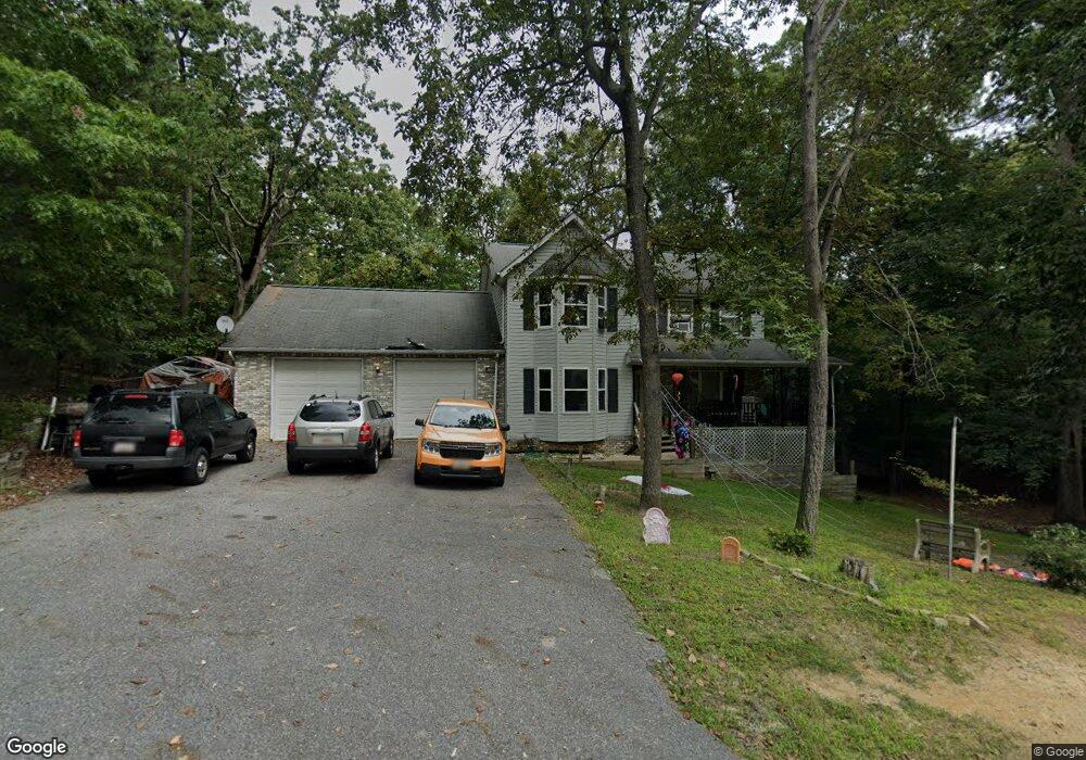
This home is located at 465 Round up Rd, Lusby, MD 20657 and is currently estimated at $391,306, approximately $206 per square foot. 465 Round up Rd is a home located in Calvert County with nearby schools including Patuxent Appeal Elementary Campus, Mill Creek Middle School, and Patuxent High School.
Ownership History
Date
Name
Owned For
Owner Type
Purchase Details
Closed on
Feb 28, 2000
Sold by
Secretary Of Housing & Urban Dev
Bought by
Tyra Mark C and Overby June A
Current Estimated Value
Purchase Details
Closed on
Aug 27, 1999
Sold by
Corrado Vince and Corrado Dana L
Bought by
Secretary Of Housing & Urban Dev
Purchase Details
Closed on
Sep 3, 1993
Sold by
Quality Built Homes
Bought by
Corrado Vince
Home Financials for this Owner
Home Financials are based on the most recent Mortgage that was taken out on this home.
Original Mortgage
$38,250
Interest Rate
7.11%
Create a Home Valuation Report for This Property
The Home Valuation Report is an in-depth analysis detailing your home's value as well as a comparison with similar homes in the area
Home Values in the Area
Average Home Value in this Area
Purchase History
| Date | Buyer | Sale Price | Title Company |
|---|---|---|---|
| Tyra Mark C | $133,001 | -- | |
| Secretary Of Housing & Urban Dev | $145,500 | -- | |
| Corrado Vince | $138,195 | -- |
Source: Public Records
Mortgage History
| Date | Status | Borrower | Loan Amount |
|---|---|---|---|
| Previous Owner | Corrado Vince | $38,250 | |
| Closed | Tyra Mark C | -- |
Source: Public Records
Tax History Compared to Growth
Tax History
| Year | Tax Paid | Tax Assessment Tax Assessment Total Assessment is a certain percentage of the fair market value that is determined by local assessors to be the total taxable value of land and additions on the property. | Land | Improvement |
|---|---|---|---|---|
| 2025 | $3,646 | $330,033 | $0 | $0 |
| 2024 | $3,646 | $297,867 | $0 | $0 |
| 2023 | $2,915 | $265,700 | $55,200 | $210,500 |
| 2022 | $2,651 | $255,133 | $0 | $0 |
| 2021 | $6,154 | $244,567 | $0 | $0 |
| 2020 | $2,863 | $234,000 | $55,200 | $178,800 |
| 2019 | $2,432 | $231,867 | $0 | $0 |
| 2018 | $2,410 | $229,733 | $0 | $0 |
| 2017 | $2,795 | $227,600 | $0 | $0 |
| 2016 | -- | $227,600 | $0 | $0 |
| 2015 | $3,343 | $227,600 | $0 | $0 |
| 2014 | $3,343 | $238,600 | $0 | $0 |
Source: Public Records
Map
Nearby Homes
- 463 Bronco Trail
- 12501 San Jose Ct
- 12476 Catalina Dr
- 12447 El Segunda Ln
- 502 Dodge Trail
- 513 Cody Trail
- 428 Buffalo Rd
- 12407 Tahoe Ct
- 12284 Bandera Ln
- 542 Chisholm Trail
- 1049 Golden Way W
- 634 Silver Rock Rd
- 1076 San Angelo Dr
- 12439 Rimrock Ln
- 1078 Fort Sill Trail
- 12361 Silver Rock Cir
- 389 Thunderbird Dr
- 12375 Algonquin Trail
- 12115 Tall Pine Trail
- 356 Clubhouse Dr
- 471 Round up Rd
- 468 Bronco Trail
- 464 Round up Rd
- 458 Bronco Trail
- 475 Round up Rd
- 470 Round up Rd
- 474 Round up Rd
- 472 Bronco Trail
- 479 Round up Rd
- 460 Round up Rd
- 478 Round up Rd
- 469 Bronco Trail
- 476 Bronco Trail
- 459 Bronco Trail
- 467 Redwood Rd
- 456 Round up Rd
- 451 Round up Rd
- 473 Bronco Trail
- 483 Round up Rd
- 452 Round up Rd