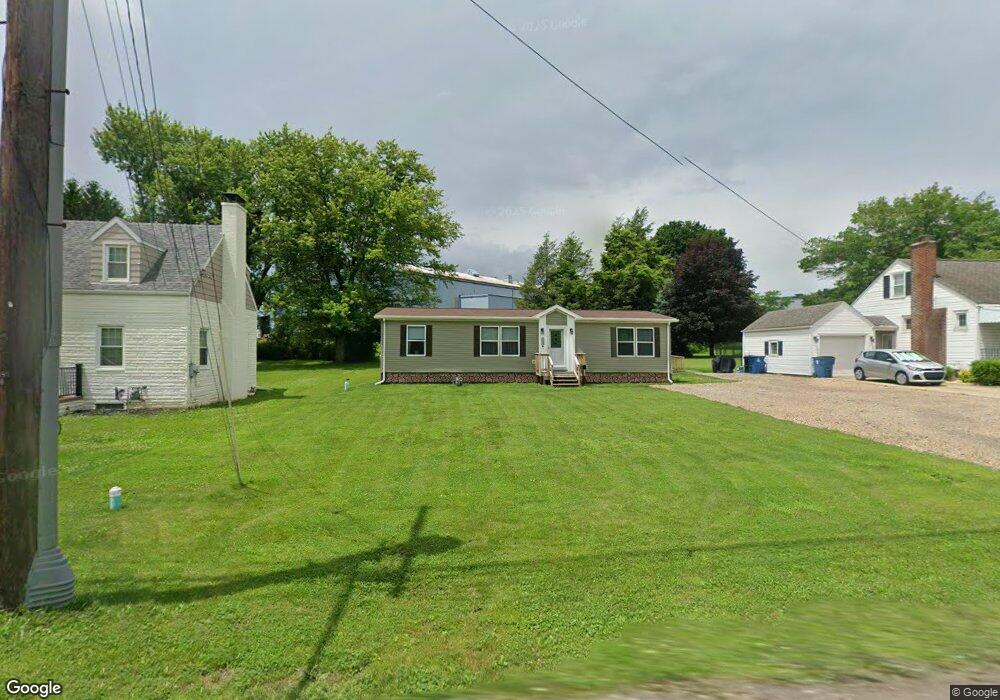
4659 State Route 982 Latrobe, PA 15650
Estimated Value: $113,000 - $239,000
--
Bed
--
Bath
1,248
Sq Ft
$124/Sq Ft
Est. Value
About This Home
This home is located at 4659 State Route 982, Latrobe, PA 15650 and is currently estimated at $154,963, approximately $124 per square foot. 4659 State Route 982 is a home with nearby schools including Greater Latrobe Junior High School, Greater Latrobe Senior High School, and Christ the Divine Teacher School.
Ownership History
Date
Name
Owned For
Owner Type
Purchase Details
Closed on
Mar 29, 2018
Sold by
Dundore Rosemary M and Dundore Rosemary
Bought by
Clair Michael J and Clair Kayla D
Current Estimated Value
Home Financials for this Owner
Home Financials are based on the most recent Mortgage that was taken out on this home.
Original Mortgage
$126,161
Outstanding Balance
$108,471
Interest Rate
4.43%
Mortgage Type
New Conventional
Estimated Equity
$46,492
Purchase Details
Closed on
May 11, 2017
Sold by
Commercial Bank And Trust Of Pa
Bought by
Dundore Rosemary
Purchase Details
Closed on
Sep 12, 2007
Sold by
Palmer Cherie B
Bought by
Cherie B Palmer Revocable Living Trust
Create a Home Valuation Report for This Property
The Home Valuation Report is an in-depth analysis detailing your home's value as well as a comparison with similar homes in the area
Home Values in the Area
Average Home Value in this Area
Purchase History
| Date | Buyer | Sale Price | Title Company |
|---|---|---|---|
| Clair Michael J | $124,900 | None Available | |
| Dundore Rosemary | $40,000 | None Available | |
| Cherie B Palmer Revocable Living Trust | -- | None Available |
Source: Public Records
Mortgage History
| Date | Status | Borrower | Loan Amount |
|---|---|---|---|
| Open | Clair Michael J | $126,161 |
Source: Public Records
Tax History Compared to Growth
Tax History
| Year | Tax Paid | Tax Assessment Tax Assessment Total Assessment is a certain percentage of the fair market value that is determined by local assessors to be the total taxable value of land and additions on the property. | Land | Improvement |
|---|---|---|---|---|
| 2025 | $894 | $2,750 | $2,750 | $0 |
| 2024 | $852 | $2,270 | $2,270 | $0 |
| 2023 | $291 | $2,270 | $2,270 | $0 |
| 2022 | $291 | $2,270 | $2,270 | $0 |
| 2021 | $288 | $2,270 | $2,270 | $0 |
| 2020 | $284 | $2,270 | $2,270 | $0 |
| 2019 | $281 | $2,270 | $2,270 | $0 |
| 2018 | $280 | $2,270 | $2,270 | $0 |
| 2017 | $276 | $2,270 | $2,270 | $0 |
| 2016 | $274 | $2,270 | $2,270 | $0 |
| 2015 | $274 | $2,270 | $2,270 | $0 |
| 2014 | $271 | $2,270 | $2,270 | $0 |
Source: Public Records
Map
Nearby Homes
- 114 Avenue B
- 2713 Wilson St
- 201 Avenue B
- 36 E Grant St
- 2133 Knox Ave
- 2023 Sylvan Ave
- 1832 Raymond Ave
- 1748 Dailey Ave
- 1939 Wood St
- 107 Horseshoe Dr
- 209 Gertrude St
- 2135 Wood St
- 1607 Ligonier St
- 1710 Raymond Ave
- 1 Bankie Dr
- 721 Lehmer St
- 1505 Raymond Ave
- 1441 Latrobe St
- 701 Fairmont St
- 1525 Latrobe St