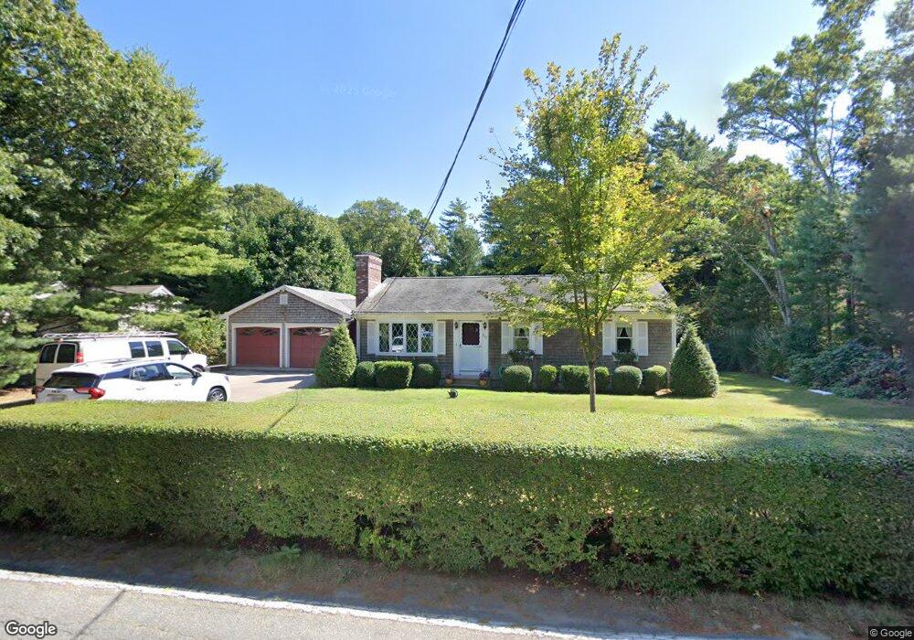
467 Locustfield Rd East Falmouth, MA 02536
Hatchville NeighborhoodEstimated Value: $563,276 - $643,000
3
Beds
3
Baths
1,340
Sq Ft
$449/Sq Ft
Est. Value
About This Home
This home is located at 467 Locustfield Rd, East Falmouth, MA 02536 and is currently estimated at $602,319, approximately $449 per square foot. 467 Locustfield Rd is a home located in Barnstable County with nearby schools including Mullen-Hall School, Morse Pond School, and Lawrence School.
Ownership History
Date
Name
Owned For
Owner Type
Purchase Details
Closed on
Aug 14, 2024
Sold by
Bento William G
Bought by
William G Bento Ret and Bento
Current Estimated Value
Purchase Details
Closed on
Jan 1, 1973
Bought by
Bento William G and Bento Beverly A
Create a Home Valuation Report for This Property
The Home Valuation Report is an in-depth analysis detailing your home's value as well as a comparison with similar homes in the area
Home Values in the Area
Average Home Value in this Area
Purchase History
| Date | Buyer | Sale Price | Title Company |
|---|---|---|---|
| William G Bento Ret | -- | None Available | |
| William G Bento Ret | -- | None Available | |
| William G Bento Ret | -- | None Available | |
| Bento William G | -- | -- |
Source: Public Records
Tax History Compared to Growth
Tax History
| Year | Tax Paid | Tax Assessment Tax Assessment Total Assessment is a certain percentage of the fair market value that is determined by local assessors to be the total taxable value of land and additions on the property. | Land | Improvement |
|---|---|---|---|---|
| 2025 | $2,682 | $456,900 | $148,300 | $308,600 |
| 2024 | $2,638 | $420,100 | $140,500 | $279,600 |
| 2023 | $2,643 | $382,000 | $140,500 | $241,500 |
| 2022 | $2,582 | $320,700 | $105,900 | $214,800 |
| 2021 | $2,502 | $294,300 | $101,300 | $193,000 |
| 2020 | $2,449 | $285,100 | $92,100 | $193,000 |
| 2019 | $2,353 | $274,900 | $92,100 | $182,800 |
| 2018 | $2,274 | $264,400 | $92,100 | $172,300 |
| 2017 | $2,198 | $257,700 | $92,100 | $165,600 |
| 2016 | $2,154 | $257,400 | $92,100 | $165,300 |
| 2015 | $2,108 | $257,400 | $92,100 | $165,300 |
| 2014 | $1,911 | $234,500 | $97,000 | $137,500 |
Source: Public Records
Map
Nearby Homes
- 12 Beach Plum Path
- 4 Josiah Path
- 7 Josiah Path
- 18 Josiah Path
- 20 Josiah Path
- 21 Josiah Path
- 30 Josiah Path
- 12 Rock Hollow Dr
- 34 Mckenna Ridge Rd
- 59 Whitecaps Dr
- 68 Deepwood Dr
- 61 Mckenna Ridge Dr
- 17 Pinewood Dr
- 273 Sandwich Rd
- 32 Jamie Ln
- 149 Brick Kiln Rd
- 25 Percival Rd
- 63 Pine Valley Dr Unit 63 aka 30A
- 70 Meredith Dr
- 471 Locustfield Rd
- 461 Locustfield Rd
- 26 Harriette Rd
- 466 Locustfield Rd
- 32 Harriette Rd
- 479 Locustfield Rd
- 460 Locustfield Rd
- 38 Harriette Rd
- 474 Locustfield Rd
- 478 Locustfield Rd
- 481 Locustfield Rd
- 481 Locustfield Rd
- 448 Locustfield Rd
- 443 Locustfield Rd
- 46 Harriette Rd
- 10 Wampum Rd
- 440 Locustfield Rd
- 485 Locustfield Rd
- 442 Locustfield Rd
- 18 Wampum Rd