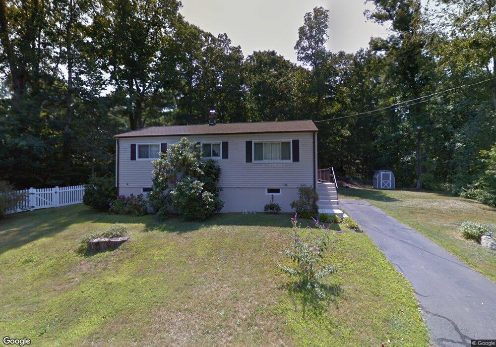
467 Mulberry Point Rd Guilford, CT 06437
Estimated Value: $376,000 - $473,837
3
Beds
1
Bath
836
Sq Ft
$503/Sq Ft
Est. Value
About This Home
This home is located at 467 Mulberry Point Rd, Guilford, CT 06437 and is currently estimated at $420,209, approximately $502 per square foot. 467 Mulberry Point Rd is a home located in New Haven County with nearby schools including E.C. Adams Middle School, A. Baldwin Middle School, and Guilford High School.
Ownership History
Date
Name
Owned For
Owner Type
Purchase Details
Closed on
Apr 27, 2001
Sold by
Est Brennan Hazel L and Smaldone Kathleen
Bought by
Zito Marlene B
Current Estimated Value
Home Financials for this Owner
Home Financials are based on the most recent Mortgage that was taken out on this home.
Original Mortgage
$118,400
Interest Rate
6.88%
Create a Home Valuation Report for This Property
The Home Valuation Report is an in-depth analysis detailing your home's value as well as a comparison with similar homes in the area
Home Values in the Area
Average Home Value in this Area
Purchase History
| Date | Buyer | Sale Price | Title Company |
|---|---|---|---|
| Zito Marlene B | $148,000 | -- |
Source: Public Records
Mortgage History
| Date | Status | Borrower | Loan Amount |
|---|---|---|---|
| Open | Zito Marlene B | $167,500 | |
| Closed | Zito Marlene B | $118,400 |
Source: Public Records
Tax History Compared to Growth
Tax History
| Year | Tax Paid | Tax Assessment Tax Assessment Total Assessment is a certain percentage of the fair market value that is determined by local assessors to be the total taxable value of land and additions on the property. | Land | Improvement |
|---|---|---|---|---|
| 2025 | $6,081 | $219,940 | $172,550 | $47,390 |
| 2024 | $5,846 | $219,940 | $172,550 | $47,390 |
| 2023 | $5,692 | $219,940 | $172,550 | $47,390 |
| 2022 | $4,588 | $137,990 | $113,050 | $24,940 |
| 2021 | $4,501 | $137,990 | $113,050 | $24,940 |
| 2020 | $4,458 | $137,990 | $113,050 | $24,940 |
| 2019 | $4,420 | $137,990 | $113,050 | $24,940 |
| 2018 | $4,316 | $137,990 | $113,050 | $24,940 |
| 2017 | $4,090 | $139,300 | $117,810 | $21,490 |
| 2016 | $3,994 | $139,300 | $117,810 | $21,490 |
| 2015 | $3,934 | $139,300 | $117,810 | $21,490 |
| 2014 | $3,820 | $139,300 | $117,810 | $21,490 |
Source: Public Records
Map
Nearby Homes
- 76 Sachem Head Rd
- 35 Bayberry Ln
- 379 Whitfield St Unit CN946
- 52 Seaside Ave
- 66 High St Unit 38
- 66 High St Unit 36
- 66 High St Unit 17
- 66 High St Unit 40
- 140 Wildrose Ave
- 505 Old Whitfield St
- 134 Water St
- 174 Whitfield St
- 65 Water St
- 12 Paddock Ln
- 427 3 Mile Course
- 64 Boston St
- 65 Prospect Ave
- 51 Pearl St
- 575 Leetes Island Rd
- 215 Uncas Point Rd
- 485 Mulberry Point Rd
- 456 Mulberry Point Rd
- 474 Mulberry Point Rd
- 503 Mulberry Point Rd
- 463 Mulberry Point Rd
- 444 Mulberry Point Rd
- 480 Mulberry Point Rd
- 492 Mulberry Point Rd
- 549 Mulberry Point Rd
- 517 Mulberry Point Rd
- 150 Deepwood Dr
- 502 Mulberry Point Rd
- 502 Mulberry Point Rd
- 429 Mulberry Point Rd
- 436 Mulberry Point Rd
- 16 Cedar Grove Rd
- 537 Mulberry Point Rd
- 181 Deepwood Dr
- 545 Mulberry Point Rd
- 461 Mulberry Point Rd