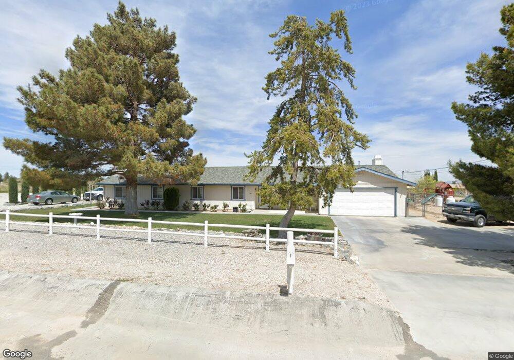
4676 Smoke Tree Rd Phelan, CA 92371
Estimated Value: $482,000 - $561,000
4
Beds
3
Baths
2,330
Sq Ft
$226/Sq Ft
Est. Value
About This Home
This home is located at 4676 Smoke Tree Rd, Phelan, CA 92371 and is currently estimated at $525,935, approximately $225 per square foot. 4676 Smoke Tree Rd is a home located in San Bernardino County with nearby schools including Phelan Elementary School, Pinon Mesa Middle School, and Serrano High School.
Ownership History
Date
Name
Owned For
Owner Type
Purchase Details
Closed on
Feb 23, 2016
Sold by
Pollard Gary and Pollard Estela
Bought by
Pollard Paul W and Pollard Rachel M
Current Estimated Value
Home Financials for this Owner
Home Financials are based on the most recent Mortgage that was taken out on this home.
Original Mortgage
$241,645
Outstanding Balance
$190,929
Interest Rate
3.68%
Mortgage Type
New Conventional
Estimated Equity
$335,006
Purchase Details
Closed on
Oct 28, 2014
Sold by
Pollard Gary and Pollard Estela
Bought by
2001 Pollard Family Trust
Purchase Details
Closed on
Jul 8, 2009
Sold by
Pollard Gary and Pollard Estela
Bought by
Pollard Gary and Pollard Estela
Home Financials for this Owner
Home Financials are based on the most recent Mortgage that was taken out on this home.
Original Mortgage
$135,000
Interest Rate
4.87%
Mortgage Type
New Conventional
Purchase Details
Closed on
Aug 15, 2006
Sold by
Pollard Gary and Pollard Estella
Bought by
Pollard Gary and Pollard Estella
Home Financials for this Owner
Home Financials are based on the most recent Mortgage that was taken out on this home.
Original Mortgage
$104,250
Interest Rate
6.67%
Mortgage Type
New Conventional
Purchase Details
Closed on
Jun 10, 2005
Sold by
Pollard Gary and Pollard Estela
Bought by
Pollard Gary and Pollard Estela
Purchase Details
Closed on
Apr 9, 2003
Sold by
Pollard Gary and Pollard Estela
Bought by
Pollard Gary and Pollard Estela
Purchase Details
Closed on
Dec 10, 2001
Sold by
Pollard Gary and Pollard Estela
Bought by
Pollard Gary and Pollard Estela
Purchase Details
Closed on
Oct 7, 1997
Sold by
Gleason Paul V and Gleason Karen L Tr
Bought by
Pollard Gary and Pollard Estela
Home Financials for this Owner
Home Financials are based on the most recent Mortgage that was taken out on this home.
Original Mortgage
$118,300
Interest Rate
7.3%
Mortgage Type
VA
Purchase Details
Closed on
Aug 15, 1994
Sold by
Gleason Paul V and Gleason Karen L
Bought by
Gleason Paul and Gleason Karen L
Create a Home Valuation Report for This Property
The Home Valuation Report is an in-depth analysis detailing your home's value as well as a comparison with similar homes in the area
Home Values in the Area
Average Home Value in this Area
Purchase History
| Date | Buyer | Sale Price | Title Company |
|---|---|---|---|
| Pollard Paul W | $235,000 | Chicago Title Inland Empire | |
| 2001 Pollard Family Trust | -- | None Available | |
| Pollard Gary | -- | Priority Title | |
| Pollard Gary | -- | First American Title Ins Co | |
| Pollard Gary | -- | First American Title Ins Co | |
| Pollard Gary | -- | -- | |
| Pollard Gary | -- | -- | |
| Pollard Gary | -- | -- | |
| Pollard Gary | -- | -- | |
| Pollard Gary | $115,000 | First American Title Ins Co | |
| Gleason Paul | -- | -- |
Source: Public Records
Mortgage History
| Date | Status | Borrower | Loan Amount |
|---|---|---|---|
| Open | Pollard Paul W | $241,645 | |
| Closed | Pollard Gary | $135,000 | |
| Closed | Pollard Gary | $104,250 | |
| Closed | Pollard Gary | $118,300 |
Source: Public Records
Tax History Compared to Growth
Tax History
| Year | Tax Paid | Tax Assessment Tax Assessment Total Assessment is a certain percentage of the fair market value that is determined by local assessors to be the total taxable value of land and additions on the property. | Land | Improvement |
|---|---|---|---|---|
| 2025 | $3,251 | $278,193 | $55,640 | $222,553 |
| 2024 | $3,251 | $272,738 | $54,549 | $218,189 |
| 2023 | $3,213 | $267,390 | $53,479 | $213,911 |
| 2022 | $3,138 | $262,147 | $52,430 | $209,717 |
| 2021 | $3,080 | $257,007 | $51,402 | $205,605 |
| 2020 | $3,041 | $254,372 | $50,875 | $203,497 |
| 2019 | $2,983 | $249,384 | $49,877 | $199,507 |
| 2018 | $2,771 | $244,494 | $48,899 | $195,595 |
| 2017 | $2,723 | $239,700 | $47,940 | $191,760 |
| 2016 | $2,283 | $209,103 | $16,859 | $192,244 |
| 2015 | $2,254 | $205,962 | $16,606 | $189,356 |
| 2014 | $2,217 | $201,928 | $16,281 | $185,647 |
Source: Public Records
Map
Nearby Homes
- 10666 Monte Vista Rd
- 9268 Sierra Vista Rd
- 10200 Johnson Rd Unit 52
- 0 Daisy Ln Unit HD25118589
- 1 Daisy Ln
- 10175 Valle Vista Rd
- 10075 Monte Vista Rd
- 4232 Coyote Rd
- 0 Mono Rd Unit PW25230494
- 0 Mono Rd Unit HD25199974
- 0 Mono Rd Unit HD25199982
- 15 Paramount Rd
- 93025 Cambria Rd
- 5299 Nielson Rd
- 113 Sheep Creek
- 2 Sandstone
- 1 Sandstone Rd
- 0 Vacant Lot Unit HD25198907
- 13299 Centola Rd
- 4591 Sandstone Rd
- 4681 Smoke Tree Rd
- 4730 Smoke Tree Rd
- 4632 Smoke Tree Rd
- 10481 Monte Vista Rd
- 10636 Monte Vista Rd
- 4637 Smoke Tree Rd
- 10448 Monte Vista Rd
- 10414 Monte Vista Rd
- 4575 Smoke Tree Rd
- 10570 Walnut Rd
- 559 Walnut Rd
- 10633 Monte Vista Rd
- 10433 Monte Vista Rd
- 4531 Smoke Tree Rd
- 4836 Walnut Rd
- 10371 Monte Vista Rd
- 4831 Walnut Rd
- 4834 Smoke Tree Rd
- 10525 Valle Vista Rd
- 10680 Monte Vista Rd