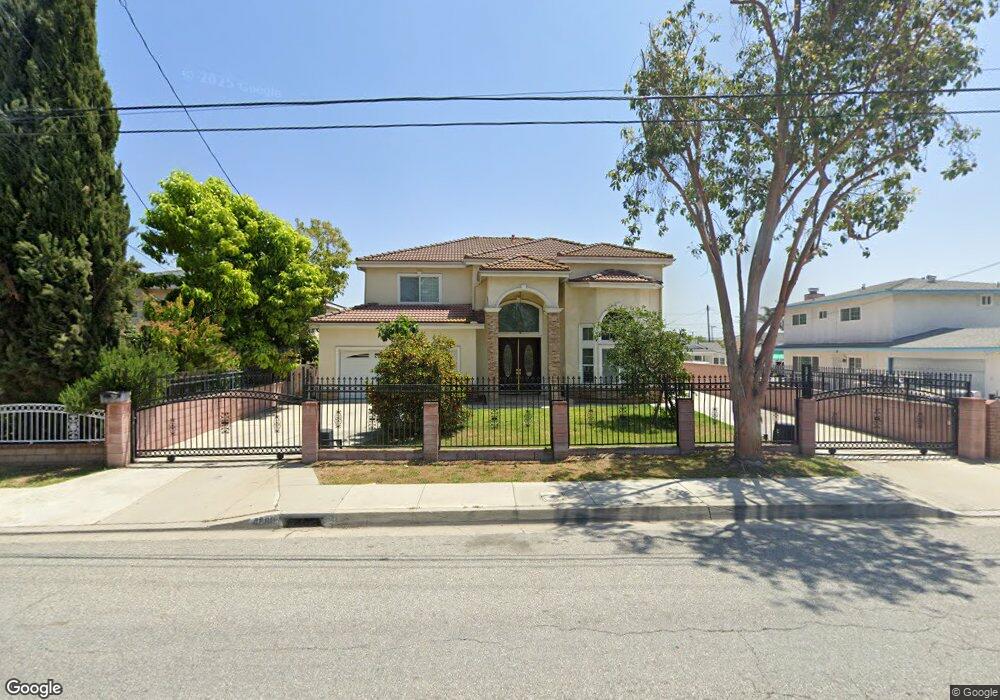
4680 Maxson Rd El Monte, CA 91732
Norwood Cherrylee NeighborhoodEstimated Value: $940,000 - $1,070,061
4
Beds
4
Baths
3,143
Sq Ft
$315/Sq Ft
Est. Value
About This Home
This home is located at 4680 Maxson Rd, El Monte, CA 91732 and is currently estimated at $990,265, approximately $315 per square foot. 4680 Maxson Rd is a home located in Los Angeles County with nearby schools including Durfee School and Arroyo High School.
Ownership History
Date
Name
Owned For
Owner Type
Purchase Details
Closed on
Nov 5, 1998
Sold by
Dang Phat
Bought by
Dang Phat
Current Estimated Value
Purchase Details
Closed on
May 1, 1998
Sold by
Nu Lai Trinh
Bought by
Dang Phat
Home Financials for this Owner
Home Financials are based on the most recent Mortgage that was taken out on this home.
Original Mortgage
$80,000
Interest Rate
7.05%
Create a Home Valuation Report for This Property
The Home Valuation Report is an in-depth analysis detailing your home's value as well as a comparison with similar homes in the area
Home Values in the Area
Average Home Value in this Area
Purchase History
| Date | Buyer | Sale Price | Title Company |
|---|---|---|---|
| Dang Phat | -- | -- | |
| Dang Phat | $105,000 | -- | |
| Dang Phat | -- | -- |
Source: Public Records
Mortgage History
| Date | Status | Borrower | Loan Amount |
|---|---|---|---|
| Previous Owner | Dang Phat | $80,000 |
Source: Public Records
Tax History
| Year | Tax Paid | Tax Assessment Tax Assessment Total Assessment is a certain percentage of the fair market value that is determined by local assessors to be the total taxable value of land and additions on the property. | Land | Improvement |
|---|---|---|---|---|
| 2025 | $7,249 | $511,904 | $134,113 | $377,791 |
| 2024 | $7,249 | $501,868 | $131,484 | $370,384 |
| 2023 | $7,108 | $492,028 | $128,906 | $363,122 |
| 2022 | $6,850 | $482,381 | $126,379 | $356,002 |
| 2021 | $6,924 | $472,923 | $123,901 | $349,022 |
| 2019 | $7,056 | $458,898 | $120,227 | $338,671 |
| 2018 | $6,825 | $449,901 | $117,870 | $332,031 |
| 2016 | $6,525 | $432,433 | $113,294 | $319,139 |
| 2015 | $6,451 | $425,939 | $111,593 | $314,346 |
| 2014 | $6,201 | $417,597 | $109,408 | $308,189 |
Source: Public Records
Map
Nearby Homes
- 4724 Durfee Ave
- 12132 Hallwood Dr
- 12118 Killian St
- 11917 Roseglen St
- 4829 La Madera Ave
- 4331 Maxson Rd
- 4731 Helmgate Dr
- 11734 Lower Azusa Rd
- 12251 Ramona Blvd
- 11654 Roseglen St
- 4159 Gilman Rd
- 12139 Ramona Blvd
- 4612 Peck Rd Unit D
- 11825 Basye St
- 12828 Ramona Blvd Unit 28
- 4045 Maxson Rd Unit G
- 11716 Hemlock St
- 4849 Peck Rd Unit 67
- 4849 Peck Rd Unit 48
- 4849 Peck Rd Unit 37
- 4688 Maxson Rd
- 4676 Maxson Rd
- 4725 Durfee Ave
- 4668 Maxson Rd
- 4743 Durfee Ave
- 4704 Maxson Rd Unit A
- 4704 Maxson Rd Unit C
- 4704 Maxson Rd Unit B
- 4733 Durfee Ave
- 12160 Ranchito St
- 4673 Maxson Rd
- 12213 Mulhall St
- 12201 Mulhall St
- 4719 Durfee Ave
- 12225 Mulhall St
- 12161 Ranchito St
- 12237 Mulhall St
- 4715 Durfee Ave
- 4741 Durfee Ave
- 12154 Ranchito St
Your Personal Tour Guide
Ask me questions while you tour the home.