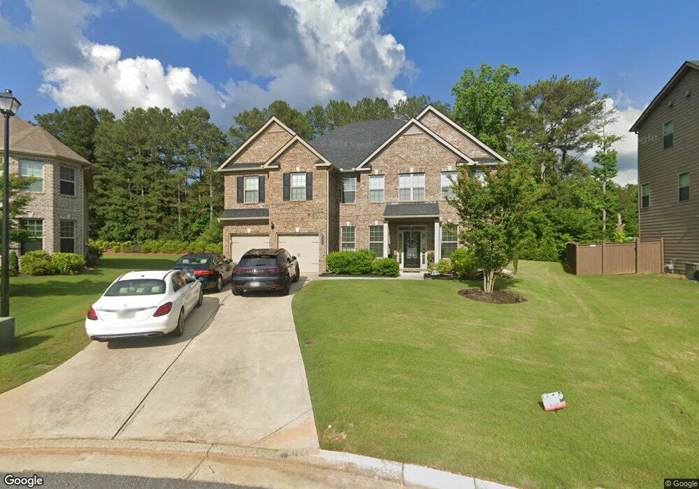
4685 Mossbrook Cir Alpharetta, GA 30004
Estimated Value: $750,000 - $815,000
5
Beds
4
Baths
4,100
Sq Ft
$190/Sq Ft
Est. Value
About This Home
This home is located at 4685 Mossbrook Cir, Alpharetta, GA 30004 and is currently estimated at $780,983, approximately $190 per square foot. 4685 Mossbrook Cir is a home with nearby schools including Sawnee Elementary School, Hendricks Middle School, and West Forsyth High School.
Ownership History
Date
Name
Owned For
Owner Type
Purchase Details
Closed on
Aug 29, 2024
Sold by
Grant Dietra D
Bought by
Sharma Shivani and Jasra Yogeshwar
Current Estimated Value
Home Financials for this Owner
Home Financials are based on the most recent Mortgage that was taken out on this home.
Original Mortgage
$695,000
Outstanding Balance
$687,621
Interest Rate
6.77%
Mortgage Type
New Conventional
Estimated Equity
$93,362
Purchase Details
Closed on
Nov 22, 2016
Bought by
Grant Dietra D
Home Financials for this Owner
Home Financials are based on the most recent Mortgage that was taken out on this home.
Original Mortgage
$388,840
Interest Rate
3.47%
Mortgage Type
New Conventional
Create a Home Valuation Report for This Property
The Home Valuation Report is an in-depth analysis detailing your home's value as well as a comparison with similar homes in the area
Home Values in the Area
Average Home Value in this Area
Purchase History
| Date | Buyer | Sale Price | Title Company |
|---|---|---|---|
| Sharma Shivani | $745,000 | None Listed On Document | |
| Grant Dietra D | $409,305 | -- |
Source: Public Records
Mortgage History
| Date | Status | Borrower | Loan Amount |
|---|---|---|---|
| Open | Sharma Shivani | $695,000 | |
| Previous Owner | Grant Dietra D | $388,840 |
Source: Public Records
Tax History Compared to Growth
Tax History
| Year | Tax Paid | Tax Assessment Tax Assessment Total Assessment is a certain percentage of the fair market value that is determined by local assessors to be the total taxable value of land and additions on the property. | Land | Improvement |
|---|---|---|---|---|
| 2025 | $5,765 | $296,440 | $72,000 | $224,440 |
| 2024 | $5,765 | $269,272 | $64,000 | $205,272 |
| 2023 | $5,454 | $270,892 | $56,000 | $214,892 |
| 2022 | $5,354 | $170,672 | $40,000 | $130,672 |
| 2021 | $4,594 | $170,672 | $40,000 | $130,672 |
| 2020 | $4,348 | $160,728 | $40,000 | $120,728 |
| 2019 | $4,509 | $166,328 | $32,000 | $134,328 |
| 2018 | $4,344 | $160,248 | $32,000 | $128,248 |
| 2017 | $4,544 | $163,722 | $32,000 | $131,722 |
Source: Public Records
Map
Nearby Homes
- 4750 Hamptons Dr
- 4465 Mossbrook Cir
- 7825 Brands Hatch Blvd
- 7880 Brands Hatch Blvd
- 4655 Hamptons Dr
- 4645 Hamptons Dr
- 212 Silver Birch Ct
- 8014 Holyoke Rd
- 7619 Campground Rd
- 6715 Bentley Trail
- 6645 Bentley Ridge Dr
- 4235 Danbury Farms Dr
- 5510 Bristlecone Pine Way
- 5530 Lacebark Pine Ct
- 6610 Tything Ct
- 5120 Bristlecone Pine Way
- 6515 Bentley Ridge Dr
- 5455 Lacebark Pine Ct
- 5465 Tallantworth Crossing
- 4685 Mossbrook Cir
- 4675 Mossbrook Cir Unit 49
- 4675 Mossbrook Cir
- 4695 Mossbrook Cir Unit 47
- 4695 Mossbrook Cir Unit 47
- 4695 Mossbrook Cir
- 4695 Mossbrook Cir
- 4705 Mossbrook Cir Unit 46
- 4705 Mossbrook Cir Unit 46
- 4705 Mossbrook Cir
- 4665 Mossbrook Cir
- 4665 Mossbrook Cir Unit 50
- 4660 Mossbrook Cir
- 4660 Mossbrook Cir Unit 26
- 4715 Mossbrook Cir
- 4810 Sweetfern Ct
- 156 Red Bank Rd
- 156 Red Bank Rd Unit A
- 156 Red Bank Rd Unit 12