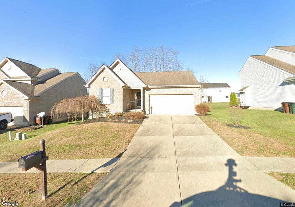
4692 Thomas David Dr Morrow, OH 45152
Estimated Value: $310,000 - $326,000
3
Beds
2
Baths
1,332
Sq Ft
$237/Sq Ft
Est. Value
About This Home
This home is located at 4692 Thomas David Dr, Morrow, OH 45152 and is currently estimated at $315,957, approximately $237 per square foot. 4692 Thomas David Dr is a home located in Warren County with nearby schools including Little Miami Early Childhood Center, Little Miami Intermediate Middle School, and Little Miami Middle School.
Ownership History
Date
Name
Owned For
Owner Type
Purchase Details
Closed on
Nov 20, 2009
Sold by
Inverness Group Incorporated
Bought by
Sostaric Janet
Current Estimated Value
Home Financials for this Owner
Home Financials are based on the most recent Mortgage that was taken out on this home.
Original Mortgage
$147,500
Outstanding Balance
$94,839
Interest Rate
5.02%
Mortgage Type
New Conventional
Estimated Equity
$221,118
Purchase Details
Closed on
Mar 29, 2007
Sold by
Nathaniel Development Co Inc
Bought by
Inverness Group Inc
Home Financials for this Owner
Home Financials are based on the most recent Mortgage that was taken out on this home.
Original Mortgage
$15,000,000
Interest Rate
6.19%
Mortgage Type
Unknown
Create a Home Valuation Report for This Property
The Home Valuation Report is an in-depth analysis detailing your home's value as well as a comparison with similar homes in the area
Home Values in the Area
Average Home Value in this Area
Purchase History
| Date | Buyer | Sale Price | Title Company |
|---|---|---|---|
| Sostaric Janet | $150,766 | Sterling Title & Assoc Llc | |
| Inverness Group Inc | $99,200 | Court Street Title |
Source: Public Records
Mortgage History
| Date | Status | Borrower | Loan Amount |
|---|---|---|---|
| Open | Sostaric Janet | $147,500 | |
| Previous Owner | Inverness Group Inc | $15,000,000 |
Source: Public Records
Tax History
| Year | Tax Paid | Tax Assessment Tax Assessment Total Assessment is a certain percentage of the fair market value that is determined by local assessors to be the total taxable value of land and additions on the property. | Land | Improvement |
|---|---|---|---|---|
| 2025 | $3,925 | $87,230 | $24,500 | $62,730 |
| 2024 | $3,925 | $87,230 | $24,500 | $62,730 |
| 2023 | $3,426 | $67,851 | $14,455 | $53,396 |
| 2022 | $3,391 | $67,851 | $14,455 | $53,396 |
| 2021 | $3,240 | $67,851 | $14,455 | $53,396 |
| 2020 | $3,227 | $57,502 | $12,250 | $45,252 |
| 2019 | $3,284 | $57,502 | $12,250 | $45,252 |
| 2018 | $3,338 | $57,502 | $12,250 | $45,252 |
| 2017 | $2,793 | $47,180 | $10,210 | $36,971 |
| 2016 | $2,850 | $47,180 | $10,210 | $36,971 |
| 2015 | $2,670 | $47,180 | $10,210 | $36,971 |
| 2014 | $2,785 | $44,090 | $9,540 | $34,550 |
| 2013 | $2,739 | $56,610 | $12,250 | $44,360 |
Source: Public Records
Map
Nearby Homes
- 3155 Rosemary Ct Unit Lot 94
- 3155 Rosemary Ct
- 4836 Jessica Suzanne Dr
- 5815 Josie’s Cove
- 4698 Jessica Suzanne Dr
- 4997 Jessica Suzanne Dr
- 5670 Julia Kate Dr
- 5039 Mary Louise Ct
- 5056 Mary Louise Ct
- 6407 Cooper Grace Ln
- 5194 Lucy James Ct
- 5015 Allens Ridge Dr
- 5101 Jessica Suzanne Dr
- 5168 Allens Ridge Dr
- 5204 Jessica Suzanne Dr
- 105 Welch Rd
- 114 Highlawn Ave
- Lot #1 Middleboro Rd
- 5467 Morrow-Blackhawk Rd
- 5750 Azra Ct
- 4678 Thomas David Dr
- 4706 Thomas David Dr
- 4664 Thomas David Dr
- 4693 Megan Danielle Dr
- 4721 Megan Danielle Dr
- 4691 Thomas David Dr Unit 13
- 4691 Thomas David Dr
- 4679 Megan Danielle Dr
- 4677 Thomas David Dr
- 4650 Thomas David Dr
- 4868 Anne Marie Dr
- 4663 Thomas David Dr
- 66 Anne Marie Dr
- 5784 Anne Marie Dr
- 4665 Megan Danielle Dr
- 54 Anne Marie Dr
- 5798 Anne Marie Dr
- 4649 Thomas David Dr
- 69 Anne Marie Dr
- 5812 Anne Marie Dr
Your Personal Tour Guide
Ask me questions while you tour the home.