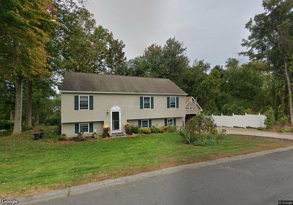
47 Bashan Rd East Haddam, CT 06423
Estimated Value: $388,000 - $431,000
3
Beds
2
Baths
1,144
Sq Ft
$355/Sq Ft
Est. Value
About This Home
This home is located at 47 Bashan Rd, East Haddam, CT 06423 and is currently estimated at $406,232, approximately $355 per square foot. 47 Bashan Rd is a home located in Middlesex County with nearby schools including East Haddam Elementary School, Nathan Hale-Ray Middle School, and Nathan Hale-Ray High School.
Ownership History
Date
Name
Owned For
Owner Type
Purchase Details
Closed on
Apr 12, 2010
Sold by
Wiernasz Linda
Bought by
Lorusso Donald
Current Estimated Value
Home Financials for this Owner
Home Financials are based on the most recent Mortgage that was taken out on this home.
Original Mortgage
$10,000
Interest Rate
5.11%
Purchase Details
Closed on
Nov 25, 2002
Sold by
Alphaterre Prop Llc
Bought by
Murray Paul E and Wiernasz Linda M
Create a Home Valuation Report for This Property
The Home Valuation Report is an in-depth analysis detailing your home's value as well as a comparison with similar homes in the area
Home Values in the Area
Average Home Value in this Area
Purchase History
| Date | Buyer | Sale Price | Title Company |
|---|---|---|---|
| Lorusso Donald | $235,000 | -- | |
| Murray Paul E | $179,900 | -- |
Source: Public Records
Mortgage History
| Date | Status | Borrower | Loan Amount |
|---|---|---|---|
| Open | Murray Paul E | $70,000 | |
| Open | Murray Paul E | $207,100 | |
| Closed | Murray Paul E | $10,000 |
Source: Public Records
Tax History Compared to Growth
Tax History
| Year | Tax Paid | Tax Assessment Tax Assessment Total Assessment is a certain percentage of the fair market value that is determined by local assessors to be the total taxable value of land and additions on the property. | Land | Improvement |
|---|---|---|---|---|
| 2025 | $5,496 | $195,880 | $64,350 | $131,530 |
| 2024 | $5,242 | $195,880 | $64,350 | $131,530 |
| 2023 | $5,044 | $195,880 | $64,350 | $131,530 |
| 2022 | $4,260 | $134,020 | $44,210 | $89,810 |
| 2021 | $4,080 | $134,020 | $44,210 | $89,810 |
| 2020 | $4,080 | $134,020 | $44,210 | $89,810 |
| 2019 | $4,080 | $134,020 | $44,210 | $89,810 |
| 2018 | $3,716 | $125,270 | $44,210 | $81,060 |
| 2017 | $3,877 | $131,060 | $45,030 | $86,030 |
| 2016 | $3,847 | $131,060 | $45,030 | $86,030 |
| 2015 | $3,759 | $131,060 | $45,030 | $86,030 |
| 2014 | $3,656 | $131,040 | $45,010 | $86,030 |
Source: Public Records
Map
Nearby Homes
- 114 Lakeside Dr
- 0 Lakeside Dr
- 8 Tom Rd
- 112 Schulman Veslak Rd
- 63 Schulman Veslak Rd
- 42 Dogwood Rd
- 53 Falls Bashan Rd
- 45 Alger Rd
- 21 Olmstead Rd
- 23 Olmstead Rd
- 55 Bogel Rd
- 154 Falls Rd
- 206 Sheepskin Hollow Rd
- 53 Shanaghans Rd
- 53 Falls Rd
- 5 Joe Williams Rd
- 115 Lakeview Dr
- 80 Orchard Rd
- 398 E Haddam Moodus Rd
- 2 Acorn Dr
- 156 Lakeside Dr
- 150 Lakeside Dr
- 150 Lakeside Dr
- 41 Bashan Rd
- 151 Lakeside Dr
- 153 Lakeside Dr
- 155 Lakeside Dr
- 34 Overlook Dr
- 0 Overlook Dr
- 159 Lakeside Dr
- 149 Lakeside Dr
- 51 Bashan Rd
- 34 Overlook Dr - (Bashan Lake)
- 163 Lakeside Dr
- 145 Lakeside Dr
- 168 Lakeside Dr
- 165 Lakeside Dr
- 140 Lakeside Dr
- 29 Overlook Dr
- 27 Overlook Dr