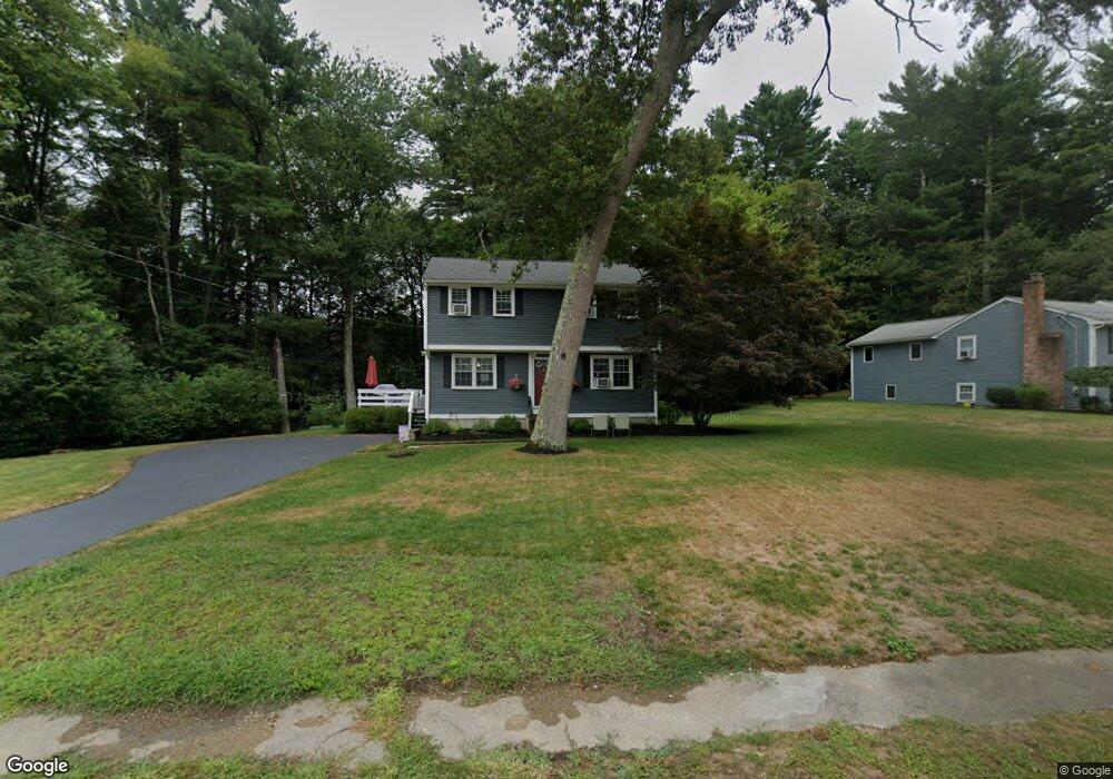
47 Hillside Cir Hanover, MA 02339
Estimated Value: $643,000 - $822,000
4
Beds
2
Baths
1,500
Sq Ft
$485/Sq Ft
Est. Value
About This Home
This home is located at 47 Hillside Cir, Hanover, MA 02339 and is currently estimated at $726,951, approximately $484 per square foot. 47 Hillside Cir is a home located in Plymouth County with nearby schools including Hanover High School, Cadence Academy Preschool - Hanover, and The Master's Academy.
Ownership History
Date
Name
Owned For
Owner Type
Purchase Details
Closed on
May 26, 2020
Sold by
Fahey William D and Fahey Chapman
Bought by
Fahey William D and Fahey Chapman
Current Estimated Value
Purchase Details
Closed on
Apr 29, 1992
Sold by
Proctor & Gamble Mfg
Bought by
Fahey William D and Fahey Chapman-Fahey M
Purchase Details
Closed on
Jan 14, 1992
Sold by
Clemmons Cantrell C and Clemmons Deanne N
Bought by
Manuf Proctor and Manuf Gamble
Create a Home Valuation Report for This Property
The Home Valuation Report is an in-depth analysis detailing your home's value as well as a comparison with similar homes in the area
Home Values in the Area
Average Home Value in this Area
Purchase History
| Date | Buyer | Sale Price | Title Company |
|---|---|---|---|
| Fahey William D | -- | None Available | |
| Fahey William D | $152,000 | -- | |
| Manuf Proctor | $156,250 | -- |
Source: Public Records
Mortgage History
| Date | Status | Borrower | Loan Amount |
|---|---|---|---|
| Previous Owner | Manuf Proctor | $125,000 | |
| Previous Owner | Manuf Proctor | $60,000 | |
| Previous Owner | Manuf Proctor | $18,879 |
Source: Public Records
Tax History
| Year | Tax Paid | Tax Assessment Tax Assessment Total Assessment is a certain percentage of the fair market value that is determined by local assessors to be the total taxable value of land and additions on the property. | Land | Improvement |
|---|---|---|---|---|
| 2025 | $7,505 | $607,700 | $269,400 | $338,300 |
| 2024 | $7,380 | $574,800 | $269,400 | $305,400 |
| 2023 | $6,715 | $497,800 | $244,900 | $252,900 |
| 2022 | $7,143 | $468,400 | $244,900 | $223,500 |
| 2021 | $7,007 | $429,100 | $222,600 | $206,500 |
| 2020 | $6,849 | $419,900 | $222,600 | $197,300 |
| 2019 | $6,681 | $407,100 | $222,600 | $184,500 |
| 2018 | $6,396 | $392,900 | $222,600 | $170,300 |
| 2017 | $6,107 | $369,700 | $209,500 | $160,200 |
| 2016 | $5,852 | $347,100 | $190,500 | $156,600 |
| 2015 | $5,606 | $347,100 | $190,500 | $156,600 |
Source: Public Records
Map
Nearby Homes
- 36 Grove St
- 51 Cervelli Farm Dr
- 37 Dr
- 23 Cervelli Farm Dr
- 38 Cervelli Farm Dr
- 9 Cervelli Farm Dr
- 250 Center St
- 95 Tecumseh Dr
- 75 School St
- 127 King St
- 114 Graham Hill Dr
- 62 Larchmont Ln
- 168 Larchmont Ln
- 108 Waterford Dr
- 506 Main St
- 33 1st Parish Ln
- 430 Brook Bend Rd
- 339 State St
- 139 Fairwood Dr
- 51 Farmside Dr
- 31 Hillside Cir
- 63 Hillside Cir
- 87 Hillside Cir
- 50 Hillside Cir
- 40 Hillside Cir
- 19 Hillside Cir
- 62 Hillside Cir
- 111 Hillside Cir
- 28 Hillside Cir
- 167 Hillside Dr
- 175 Hillside Dr
- 113 Hillside Cir
- 155 Hillside Dr
- 82 Hillside Cir
- 72 Hillside Cir
- 92 Hillside Cir
- 16 Hillside Cir
- 191 Hillside Dr
- 106 Hillside Cir
- 131 Hillside Dr
Your Personal Tour Guide
Ask me questions while you tour the home.