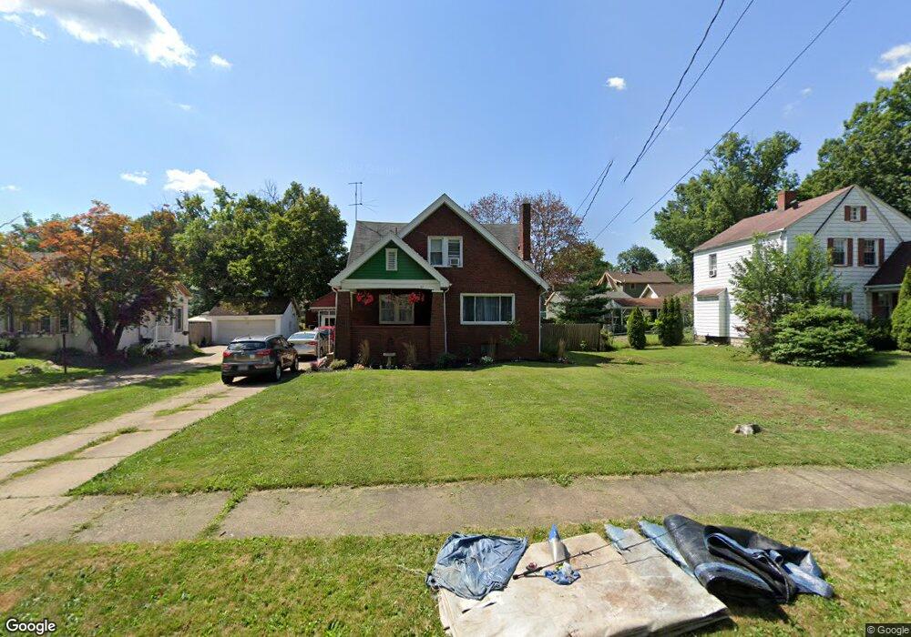
47 Maple Dr Youngstown, OH 44512
Estimated Value: $135,000 - $141,000
3
Beds
2
Baths
1,470
Sq Ft
$94/Sq Ft
Est. Value
About This Home
This home is located at 47 Maple Dr, Youngstown, OH 44512 and is currently estimated at $138,691, approximately $94 per square foot. 47 Maple Dr is a home located in Mahoning County with nearby schools including Boardman Glenwood Junior High School, Boardman High School, and Horizon Science Academy - Youngstown.
Ownership History
Date
Name
Owned For
Owner Type
Purchase Details
Closed on
Dec 5, 2011
Sold by
Shilling James D
Bought by
Strock Joseph A and Strock Nicole L
Current Estimated Value
Home Financials for this Owner
Home Financials are based on the most recent Mortgage that was taken out on this home.
Original Mortgage
$51,656
Outstanding Balance
$34,653
Interest Rate
3.99%
Mortgage Type
FHA
Estimated Equity
$104,038
Purchase Details
Closed on
Nov 18, 2008
Sold by
Shilling George R
Bought by
Shilling James D
Purchase Details
Closed on
May 6, 2005
Sold by
Schilling Marjorie
Bought by
Shilling George R
Purchase Details
Closed on
Feb 1, 1972
Bought by
Shilling Marjorie
Create a Home Valuation Report for This Property
The Home Valuation Report is an in-depth analysis detailing your home's value as well as a comparison with similar homes in the area
Home Values in the Area
Average Home Value in this Area
Purchase History
| Date | Buyer | Sale Price | Title Company |
|---|---|---|---|
| Strock Joseph A | $53,000 | Attorney | |
| Shilling James D | -- | Attorney | |
| Shilling George R | -- | -- | |
| Shilling Marjorie | -- | -- |
Source: Public Records
Mortgage History
| Date | Status | Borrower | Loan Amount |
|---|---|---|---|
| Open | Strock Joseph A | $51,656 |
Source: Public Records
Tax History
| Year | Tax Paid | Tax Assessment Tax Assessment Total Assessment is a certain percentage of the fair market value that is determined by local assessors to be the total taxable value of land and additions on the property. | Land | Improvement |
|---|---|---|---|---|
| 2025 | $1,724 | $34,490 | $2,770 | $31,720 |
| 2024 | $1,764 | $34,490 | $2,770 | $31,720 |
| 2023 | $1,740 | $34,490 | $2,770 | $31,720 |
| 2022 | $1,317 | $19,830 | $2,740 | $17,090 |
| 2021 | $1,318 | $19,830 | $2,740 | $17,090 |
| 2020 | $1,325 | $19,830 | $2,740 | $17,090 |
| 2019 | $1,334 | $17,540 | $2,420 | $15,120 |
| 2018 | $1,115 | $17,540 | $2,420 | $15,120 |
| 2017 | $1,112 | $17,540 | $2,420 | $15,120 |
| 2016 | $1,178 | $18,410 | $2,630 | $15,780 |
| 2015 | $1,155 | $18,410 | $2,630 | $15,780 |
| 2014 | $1,158 | $18,410 | $2,630 | $15,780 |
| 2013 | $1,143 | $18,410 | $2,630 | $15,780 |
Source: Public Records
Map
Nearby Homes
- 4508 Southern Blvd
- 4441 Southern Blvd
- 63 Clifton Dr
- 86 Terrace Dr
- 28 Terrace Dr
- 28 Jennette Dr
- 148 Clifton Dr
- 4833 Oak Knoll Dr
- 189 Beechwood Dr
- 132 Jennette Dr
- 4127 Southern Blvd
- 4250 Oak Knoll Dr
- 196 Maywood Dr
- 3916 Howard St
- 153 Overhill Rd
- 192 Hollywood Ave
- 4141 Windsor Rd
- 173 Clarencedale Ave
- 188 Clarencedale Ave
- 124 E Midlothian Blvd
Your Personal Tour Guide
Ask me questions while you tour the home.