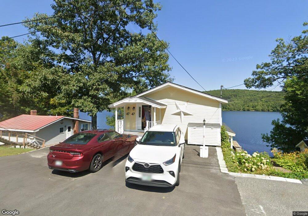
47 Nh Route 4a Enfield, NH 03748
Estimated Value: $753,000 - $819,434
2
Beds
2
Baths
2,156
Sq Ft
$366/Sq Ft
Est. Value
About This Home
This home is located at 47 Nh Route 4a, Enfield, NH 03748 and is currently estimated at $788,109, approximately $365 per square foot. 47 Nh Route 4a is a home located in Grafton County with nearby schools including Enfield Village School, Indian River School, and Mascoma Valley Regional High School.
Ownership History
Date
Name
Owned For
Owner Type
Purchase Details
Closed on
Mar 1, 2004
Sold by
Fletcher Jay L and Fletcher Elizabeth C
Bought by
Wetherdon Peter and Wetherdon Isabel A
Current Estimated Value
Home Financials for this Owner
Home Financials are based on the most recent Mortgage that was taken out on this home.
Original Mortgage
$202,400
Outstanding Balance
$94,460
Interest Rate
5.65%
Mortgage Type
Purchase Money Mortgage
Estimated Equity
$693,649
Create a Home Valuation Report for This Property
The Home Valuation Report is an in-depth analysis detailing your home's value as well as a comparison with similar homes in the area
Home Values in the Area
Average Home Value in this Area
Purchase History
| Date | Buyer | Sale Price | Title Company |
|---|---|---|---|
| Wetherdon Peter | $253,000 | -- |
Source: Public Records
Mortgage History
| Date | Status | Borrower | Loan Amount |
|---|---|---|---|
| Open | Wetherdon Peter | $20,000 | |
| Open | Wetherdon Peter | $202,400 |
Source: Public Records
Tax History Compared to Growth
Tax History
| Year | Tax Paid | Tax Assessment Tax Assessment Total Assessment is a certain percentage of the fair market value that is determined by local assessors to be the total taxable value of land and additions on the property. | Land | Improvement |
|---|---|---|---|---|
| 2024 | $10,860 | $642,200 | $334,300 | $307,900 |
| 2023 | $9,859 | $363,000 | $184,200 | $178,800 |
| 2022 | $9,200 | $357,300 | $184,200 | $173,100 |
| 2021 | $8,972 | $357,300 | $184,200 | $173,100 |
| 2020 | $1,358 | $357,300 | $184,200 | $173,100 |
| 2015 | $8,101 | $323,000 | $172,000 | $151,000 |
| 2014 | $7,900 | $341,100 | $186,800 | $154,300 |
| 2013 | $7,272 | $341,100 | $186,800 | $154,300 |
| 2012 | $6,924 | $341,100 | $186,800 | $154,300 |
Source: Public Records
Map
Nearby Homes
- 21 Evenchance Rd
- 86 Route 4a Unit 19U
- 86 Nh Route 4a Unit 8L
- 86 Nh Route 4a Unit 5U
- 86 Nh Route 4a Unit 6 Upper
- 56 Daniels Dr
- 0 Manchester Dr Unit 26
- 7 Flanders St
- 154 Sunset Rock Rd
- 503 Dartmouth College Hwy
- 511 Dartmouth College Hwy
- 151 Sunset Rock Rd
- 25 Union St
- 510 Dartmouth College Hwy
- 430 Dartmouth College Hwy
- 0 Lovejoy Brook Rd
- 262 Dartmouth College Hwy
- 20 Bonardi Dr
- 20 Alden Rd
- 321 Meriden Rd
- 41 Nh Route 4a
- 48 Nh Route 4a
- 49 Nh Route 4a
- 49 New Hampshire 4a
- 46 Nh Route 4a
- 51 New Hampshire 4a
- 51 Nh Route 4a
- 37 Nh Route 4a
- 52 Nh Route 4a
- 40 Nh Route 4
- 40 Nh Route 4a
- 58 Nh Route 4a
- 35 Nh Route 4a
- 53 Nh Route 4a
- 38 Nh Route 4a
- 34 Nh Route 4a
- 31 Nh Route 4a
- 34 New Hampshire 4a
- 29 Nh Route 4a
- 57 Nh Route 4a