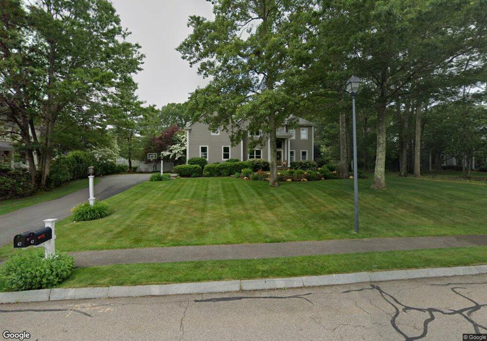
47 Old Stable Dr Mansfield, MA 02048
Estimated Value: $1,145,929 - $1,388,000
4
Beds
3
Baths
3,401
Sq Ft
$374/Sq Ft
Est. Value
About This Home
This home is located at 47 Old Stable Dr, Mansfield, MA 02048 and is currently estimated at $1,271,982, approximately $374 per square foot. 47 Old Stable Dr is a home located in Bristol County with nearby schools including Jordan/Jackson Elementary School, Everett W. Robinson Elementary School, and Harold L. Qualters Middle School.
Ownership History
Date
Name
Owned For
Owner Type
Purchase Details
Closed on
Oct 6, 2020
Sold by
Wolfe Michael B and Wolfe Linda J
Bought by
Carr Danielle and Carr William C
Current Estimated Value
Home Financials for this Owner
Home Financials are based on the most recent Mortgage that was taken out on this home.
Original Mortgage
$510,000
Outstanding Balance
$453,618
Interest Rate
2.9%
Mortgage Type
New Conventional
Estimated Equity
$818,364
Purchase Details
Closed on
Dec 1, 2003
Sold by
Mac Homes Inc
Bought by
Tishler Gary J and Tishler Marybeth
Purchase Details
Closed on
Jul 24, 1998
Sold by
Mac Homes Inc
Bought by
Wolfe Michael B
Home Financials for this Owner
Home Financials are based on the most recent Mortgage that was taken out on this home.
Original Mortgage
$75,000
Interest Rate
6.9%
Create a Home Valuation Report for This Property
The Home Valuation Report is an in-depth analysis detailing your home's value as well as a comparison with similar homes in the area
Home Values in the Area
Average Home Value in this Area
Purchase History
| Date | Buyer | Sale Price | Title Company |
|---|---|---|---|
| Carr Danielle | $925,000 | None Available | |
| Tishler Gary J | $759,000 | -- | |
| Wolfe Michael B | $379,900 | -- |
Source: Public Records
Mortgage History
| Date | Status | Borrower | Loan Amount |
|---|---|---|---|
| Open | Carr Danielle | $510,000 | |
| Previous Owner | Wolfe Michael B | $188,000 | |
| Previous Owner | Wolfe Michael B | $75,000 | |
| Previous Owner | Wolfe Michael B | $200,000 |
Source: Public Records
Tax History
| Year | Tax Paid | Tax Assessment Tax Assessment Total Assessment is a certain percentage of the fair market value that is determined by local assessors to be the total taxable value of land and additions on the property. | Land | Improvement |
|---|---|---|---|---|
| 2025 | $13,777 | $1,046,100 | $266,000 | $780,100 |
| 2024 | $13,446 | $996,000 | $278,100 | $717,900 |
| 2023 | $12,856 | $912,400 | $278,100 | $634,300 |
| 2022 | $12,266 | $808,600 | $257,400 | $551,200 |
| 2021 | $10,858 | $787,900 | $242,600 | $545,300 |
| 2020 | $11,889 | $774,000 | $242,600 | $531,400 |
| 2019 | $10,522 | $772,700 | $225,300 | $547,400 |
| 2018 | $11,721 | $752,800 | $214,900 | $537,900 |
| 2017 | $11,001 | $732,400 | $208,800 | $523,600 |
| 2016 | $10,779 | $699,500 | $229,000 | $470,500 |
| 2015 | $10,486 | $676,500 | $229,000 | $447,500 |
Source: Public Records
Map
Nearby Homes
- 4 Erick Rd Unit 90
- 15 Coach Rd
- 34 Kevins Way
- 26 Fredric Ln
- 26 Kathleen Grant Rd
- 890 Maple St
- 631 East St Unit L101
- 157 Highland St
- 212 Mill St
- 53 Elyse Rd
- 73 Elyse Rd
- 261 East St
- 251 Poquanticut Ave
- 7 Fieldstone Dr
- 1 Deer Path Ln
- 117 Allen Rd
- 14 Windchime Dr
- 555 Foundry St Unit B
- 46 Hope St
- 23 Cutter Dr
- 51 Old Stable Dr
- 43 Old Stable Dr
- 46 Old Stable Dr
- 83 Colonial Dr
- 78 Colonial Dr
- 55 Old Stable Dr
- 39 Old Stable Dr
- 42 Old Stable Dr
- 41 Old North Trail
- 50 Old Stable Dr
- 41 Old Trail N
- 79 Colonial Dr
- 40 Old Stable Dr
- 45 Old North Trail
- 56 Old Stable Dr
- 59 Old Stable Dr
- 22 Plantation Rd
- 35 North Trail
- 35 Old North Trail
- 55 Old North Trail
Your Personal Tour Guide
Ask me questions while you tour the home.