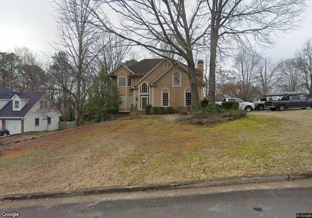
47 Saint Aurics Dr Unit 2 Suwanee, GA 30024
Estimated Value: $423,183 - $443,000
4
Beds
3
Baths
2,374
Sq Ft
$182/Sq Ft
Est. Value
About This Home
This home is located at 47 Saint Aurics Dr Unit 2, Suwanee, GA 30024 and is currently estimated at $432,046, approximately $181 per square foot. 47 Saint Aurics Dr Unit 2 is a home located in Gwinnett County with nearby schools including Walnut Grove Elementary School, Creekland Middle School, and Collins Hill High School.
Ownership History
Date
Name
Owned For
Owner Type
Purchase Details
Closed on
Sep 30, 1998
Sold by
Home Traders Inc
Bought by
Sanborn Patsy Jean and Sanborn Curran
Current Estimated Value
Home Financials for this Owner
Home Financials are based on the most recent Mortgage that was taken out on this home.
Original Mortgage
$147,000
Interest Rate
6.8%
Mortgage Type
New Conventional
Create a Home Valuation Report for This Property
The Home Valuation Report is an in-depth analysis detailing your home's value as well as a comparison with similar homes in the area
Home Values in the Area
Average Home Value in this Area
Purchase History
| Date | Buyer | Sale Price | Title Company |
|---|---|---|---|
| Sanborn Patsy Jean | $14,700 | -- |
Source: Public Records
Mortgage History
| Date | Status | Borrower | Loan Amount |
|---|---|---|---|
| Open | Sanborn Patsy Jean | $14,700 | |
| Previous Owner | Sanborn Patsy Jean | $147,000 |
Source: Public Records
Tax History
| Year | Tax Paid | Tax Assessment Tax Assessment Total Assessment is a certain percentage of the fair market value that is determined by local assessors to be the total taxable value of land and additions on the property. | Land | Improvement |
|---|---|---|---|---|
| 2025 | $1,013 | $179,720 | $28,000 | $151,720 |
| 2024 | $4,524 | $171,000 | $34,000 | $137,000 |
| 2023 | $4,524 | $162,880 | $31,600 | $131,280 |
| 2022 | $4,117 | $153,000 | $29,200 | $123,800 |
| 2021 | $3,147 | $103,720 | $17,200 | $86,520 |
| 2020 | $3,170 | $103,720 | $17,200 | $86,520 |
| 2019 | $3,099 | $103,720 | $17,200 | $86,520 |
| 2018 | $3,103 | $103,720 | $17,200 | $86,520 |
| 2016 | $2,684 | $83,320 | $14,440 | $68,880 |
| 2015 | $2,467 | $72,520 | $12,400 | $60,120 |
| 2014 | $2,477 | $72,520 | $12,400 | $60,120 |
Source: Public Records
Map
Nearby Homes
- 2390 Walnut Grove Way
- 2164 Cape Liberty Dr
- 2372 Merrymount Dr Unit 2
- 2382 Merrymount Dr Unit 2
- 30 Karen Camile Dr
- 2285 Wildwood Lake Dr
- 2001 Stone Forest Dr
- 2105 Laurel Lake Dr
- 1985 Tyler Trace
- 1971 Fernwood Dr
- 2061 Wildcat Cliffs Ln
- 2165 Wildwood Lake Dr
- 291 Shore Dr
- 2035 Wildcat Cliffs Way Unit 1
- 2275 Shore View Way
- 2205 Parliament Dr
- 250 Camden Creek Ct
- 2512 Herndon Rd
- 332 Clarion Rd
- 260 Wildcat Lake Dr
- 50 Saint Aurics Dr Unit 2
- 53 Saint Aurics Dr Unit 2
- 56 Saint Aurics Dr
- 37 Saint Aurics Dr Unit 3
- 2245 Saint Thomas Way Unit 1
- 44 Saint Aurics Dr
- 65 Saint Aurics Dr Unit 2
- 2235 Saint Thomas Way Unit 1
- 38 Saint Aurics Dr
- 62 Saint Aurics Dr
- 135 Richland Pkwy
- 71 Saint Aurics Dr Unit 2
- 32 Saint Aurics Dr
- 31 Saint Aurics Dr Unit 2
- 68 Saint Aurics Dr
- 2215 Saint Thomas Way Unit 1
- 145 Richland Pkwy
- 77 Saint Aurics Dr
- 25 Saint Aurics Dr Unit 2
- 2240 Saint Thomas Way
Your Personal Tour Guide
Ask me questions while you tour the home.