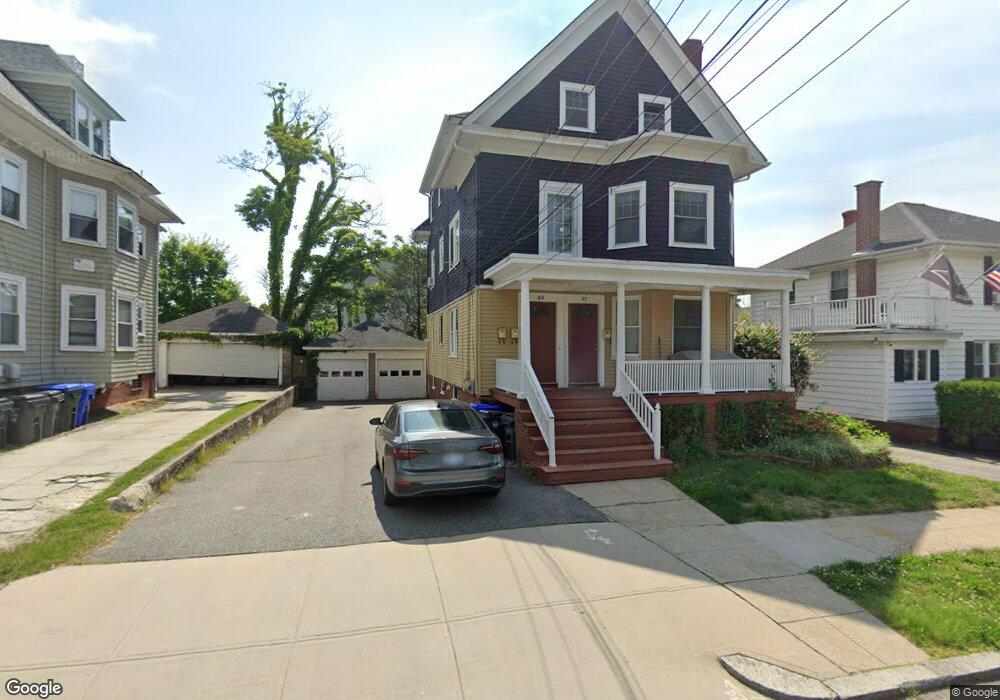
47 Tyndall Ave Unit 49 Providence, RI 02908
Elmhurst NeighborhoodEstimated Value: $480,627 - $656,000
6
Beds
3
Baths
2,696
Sq Ft
$222/Sq Ft
Est. Value
About This Home
This home is located at 47 Tyndall Ave Unit 49, Providence, RI 02908 and is currently estimated at $598,657, approximately $222 per square foot. 47 Tyndall Ave Unit 49 is a home located in Providence County with nearby schools including Asa Messer Elementary School, Charles N. Fortes Elementary School, and Veazie Street Elementary School.
Ownership History
Date
Name
Owned For
Owner Type
Purchase Details
Closed on
Nov 19, 2024
Sold by
Longo Margaret A
Bought by
Margaret A Longo Ret
Current Estimated Value
Purchase Details
Closed on
Jun 24, 1994
Sold by
Dalfonso Robert A and Dalfonso Gloria
Bought by
Longo Margaret A
Create a Home Valuation Report for This Property
The Home Valuation Report is an in-depth analysis detailing your home's value as well as a comparison with similar homes in the area
Home Values in the Area
Average Home Value in this Area
Purchase History
| Date | Buyer | Sale Price | Title Company |
|---|---|---|---|
| Margaret A Longo Ret | -- | None Available | |
| Longo Margaret A | $118,000 | -- |
Source: Public Records
Mortgage History
| Date | Status | Borrower | Loan Amount |
|---|---|---|---|
| Previous Owner | Longo Margaret A | $201,300 | |
| Previous Owner | Longo Margaret A | $219,000 | |
| Previous Owner | Longo Margaret A | $170,000 | |
| Previous Owner | Longo Margaret A | $152,000 |
Source: Public Records
Tax History Compared to Growth
Tax History
| Year | Tax Paid | Tax Assessment Tax Assessment Total Assessment is a certain percentage of the fair market value that is determined by local assessors to be the total taxable value of land and additions on the property. | Land | Improvement |
|---|---|---|---|---|
| 2025 | $4,580 | $606,600 | $209,300 | $397,300 |
| 2024 | $6,793 | $370,200 | $104,600 | $265,600 |
| 2023 | $6,793 | $370,200 | $104,600 | $265,600 |
| 2022 | $5,799 | $370,200 | $104,600 | $265,600 |
| 2021 | $5,799 | $236,100 | $68,900 | $167,200 |
| 2020 | $3,479 | $236,100 | $68,900 | $167,200 |
| 2019 | $5,799 | $236,100 | $68,900 | $167,200 |
| 2018 | $5,254 | $164,400 | $57,000 | $107,400 |
| 2017 | $5,254 | $164,400 | $57,000 | $107,400 |
| 2016 | $5,254 | $164,400 | $57,000 | $107,400 |
| 2015 | $4,816 | $145,500 | $52,400 | $93,100 |
| 2014 | $4,911 | $145,500 | $52,400 | $93,100 |
| 2013 | $4,911 | $145,500 | $52,400 | $93,100 |
Source: Public Records
Map
Nearby Homes
- 15 Pinehurst Ave
- 49 Pembroke Ave
- 308 Pleasant Valley Pkwy
- 94 Garfield Ave
- 178 Eaton St
- 72 Hilltop Ave
- 111 Arbor Dr
- 23 Richter St
- 39 Richter St
- 841 Smith St
- 154 Camden Ave
- 324 River Ave
- 331 Douglas Ave
- 457 Douglas Ave
- 359 Douglas Ave
- 117 Sharon St Unit 2
- 117 Sharon St
- 117 Sharon St Unit 1
- 25 Mowry St
- 17 Alma St
- 47 Tyndall Ave Unit 3
- 51 Tyndall Ave
- 41 Tyndall Ave
- 58 Pinehurst Ave
- 37 Tyndall Ave
- 57 Tyndall Ave
- 52 Pinehurst Ave Unit 54
- 64 Pinehurst Ave
- 48 Pinehurst Ave
- 68 Pinehurst Ave
- 31 Tyndall Ave
- 61 Tyndall Ave
- 50 Tyndall Ave
- 42 Pinehurst Ave
- 52 Tyndall Ave
- 72 Pinehurst Ave
- 36 Tyndall Ave
- 36 Tyndall Ave Unit 1
- 67 Tyndall Ave
- 60 Tyndall Ave