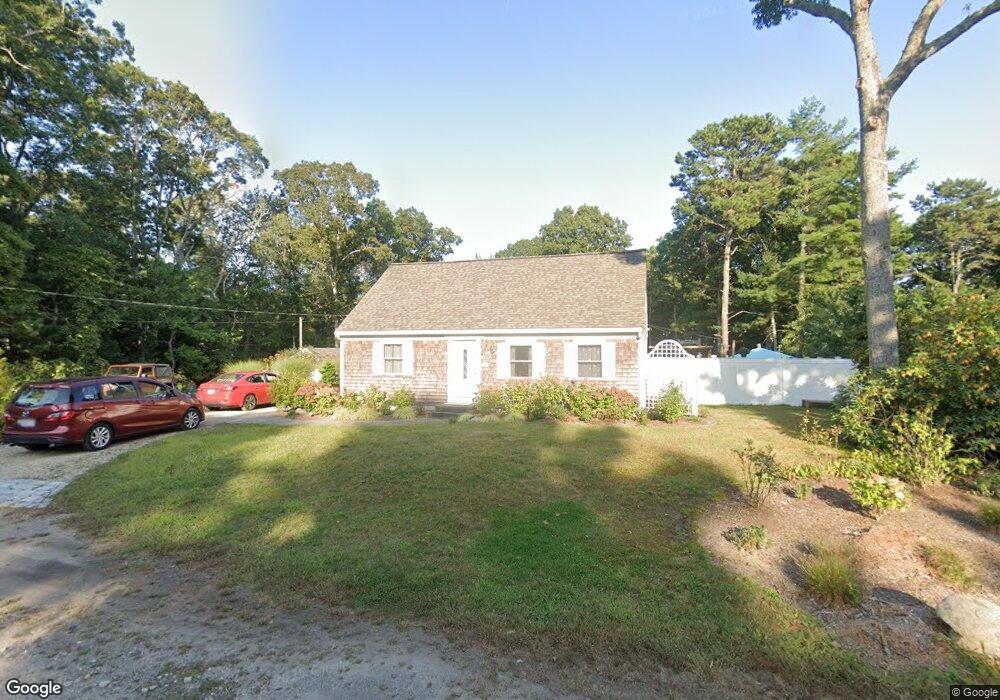
47 Wampanoag Ave Mashpee, MA 02649
Estimated Value: $650,343 - $733,000
4
Beds
3
Baths
1,500
Sq Ft
$456/Sq Ft
Est. Value
About This Home
This home is located at 47 Wampanoag Ave, Mashpee, MA 02649 and is currently estimated at $683,586, approximately $455 per square foot. 47 Wampanoag Ave is a home located in Barnstable County with nearby schools including Kenneth C. Coombs School, Quashnet School, and Mashpee Middle School.
Ownership History
Date
Name
Owned For
Owner Type
Purchase Details
Closed on
May 24, 2017
Sold by
Smaykiewicz Carol and Smaykiewicz Omar
Bought by
47 Wampanoag Avenue Nt
Current Estimated Value
Purchase Details
Closed on
Feb 13, 2017
Sold by
Smaykiewicz Carol and Smaykiewicz Omar
Bought by
47 Wampanoag Avenue Nt
Purchase Details
Closed on
Jul 31, 1973
Bought by
Smaykiewicz Omar and Smaykiewicz Carol
Create a Home Valuation Report for This Property
The Home Valuation Report is an in-depth analysis detailing your home's value as well as a comparison with similar homes in the area
Home Values in the Area
Average Home Value in this Area
Purchase History
| Date | Buyer | Sale Price | Title Company |
|---|---|---|---|
| 47 Wampanoag Avenue Nt | -- | -- | |
| 47 Wampanoag Avenue Nt | -- | -- | |
| Smaykiewicz Omar | -- | -- |
Source: Public Records
Tax History Compared to Growth
Tax History
| Year | Tax Paid | Tax Assessment Tax Assessment Total Assessment is a certain percentage of the fair market value that is determined by local assessors to be the total taxable value of land and additions on the property. | Land | Improvement |
|---|---|---|---|---|
| 2025 | $3,948 | $596,300 | $204,100 | $392,200 |
| 2024 | $3,596 | $559,200 | $185,500 | $373,700 |
| 2023 | $3,396 | $484,500 | $176,700 | $307,800 |
| 2022 | $3,235 | $396,000 | $143,600 | $252,400 |
| 2021 | $3,184 | $351,000 | $129,400 | $221,600 |
| 2020 | $3,072 | $337,900 | $124,400 | $213,500 |
| 2019 | $8,951 | $325,400 | $124,400 | $201,000 |
| 2018 | $2,779 | $311,500 | $124,400 | $187,100 |
| 2017 | $8,616 | $294,700 | $124,400 | $170,300 |
| 2016 | $2,632 | $284,800 | $124,400 | $160,400 |
| 2015 | $2,518 | $276,400 | $124,400 | $152,000 |
| 2014 | $2,413 | $257,000 | $105,500 | $151,500 |
Source: Public Records
Map
Nearby Homes
- 54 Sassacus Rd
- 116 Grey Hawk Dr Unit 116
- 116 Grey Hawk Dr
- 44 Twin Oaks Dr
- 44 Twin Oaks Dr Unit 44
- 20 Twin Oaks Dr Unit 20
- 20 Twin Oaks Dr
- 152 Algonquin Ave
- 72 Grey Hawk Dr Unit 670
- 72 Grey Hawk Dr
- 300 Nathan Ellis Hwy Unit 50
- 23 Sea Spray Ave Unit 563
- 23 Sea Spray Ave
- 18 Stony Brook Dr
- 18 Stony Brook Dr Unit 18
- 17 Chadwick Ct Unit 17
- 17 Chadwick Ct
- 22 Grey Hawk Dr
- 211 James Cir
- 16 Grey Hawk Dr Unit 16
- 47 Wampanoag Ave Unit 1
- 43 Sassacus Rd
- 62 Ninigret Ave
- 49 Wampanoag Ave
- 48 Wampanoag Ave
- 74 Ninigret Ave
- 52 Wampanoag Ave
- 8 Sassacus Rd
- 23 Sassacus Rd
- 56 Wampanoag Ave
- 37 Massasoit Ave
- 71 Ninigret Ave
- 33 Massasoit Ave
- 41 Massasoit Ave
- 34 Cappawack Rd
- 45 Massasoit Ave
- 77 Ninigret Ave
- 30 Cappawack Rd
- 60 Wampanoag Ave
- 83 Ninigret Ave