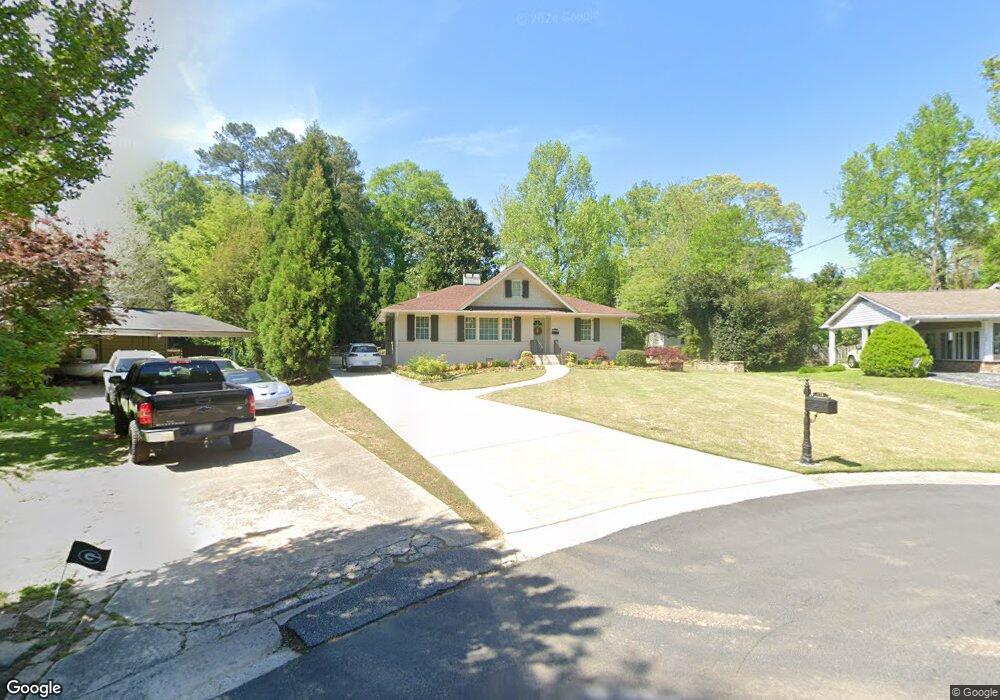
470 Brookwood Ct SW Marietta, GA 30064
Southwestern Marietta NeighborhoodEstimated Value: $498,000 - $605,000
2
Beds
4
Baths
1,934
Sq Ft
$289/Sq Ft
Est. Value
About This Home
This home is located at 470 Brookwood Ct SW, Marietta, GA 30064 and is currently estimated at $559,137, approximately $289 per square foot. 470 Brookwood Ct SW is a home located in Cobb County with nearby schools including A.L. Burruss Elementary School, Marietta Sixth Grade Academy, and Marietta Middle School.
Ownership History
Date
Name
Owned For
Owner Type
Purchase Details
Closed on
Dec 5, 2022
Sold by
Morrell Living Trust
Bought by
Billy Theron Morrell Revocable Trust
Current Estimated Value
Purchase Details
Closed on
Mar 5, 2015
Sold by
Morrell Billy Theron
Bought by
The Morrell Liv Tr
Create a Home Valuation Report for This Property
The Home Valuation Report is an in-depth analysis detailing your home's value as well as a comparison with similar homes in the area
Home Values in the Area
Average Home Value in this Area
Purchase History
| Date | Buyer | Sale Price | Title Company |
|---|---|---|---|
| Billy Theron Morrell Revocable Trust | -- | -- | |
| The Morrell Liv Tr | -- | -- |
Source: Public Records
Tax History Compared to Growth
Tax History
| Year | Tax Paid | Tax Assessment Tax Assessment Total Assessment is a certain percentage of the fair market value that is determined by local assessors to be the total taxable value of land and additions on the property. | Land | Improvement |
|---|---|---|---|---|
| 2025 | $527 | $211,048 | $70,000 | $141,048 |
| 2024 | $527 | $211,048 | $70,000 | $141,048 |
| 2023 | $374 | $215,780 | $70,000 | $145,780 |
| 2022 | $527 | $161,360 | $38,000 | $123,360 |
| 2021 | $541 | $113,468 | $38,000 | $75,468 |
| 2020 | $541 | $113,468 | $38,000 | $75,468 |
| 2019 | $540 | $105,328 | $36,000 | $69,328 |
| 2018 | $540 | $105,328 | $36,000 | $69,328 |
| 2017 | $498 | $72,236 | $22,000 | $50,236 |
| 2016 | $403 | $58,548 | $22,000 | $36,548 |
| 2015 | $439 | $58,548 | $22,000 | $36,548 |
| 2014 | $422 | $54,496 | $0 | $0 |
Source: Public Records
Map
Nearby Homes
- 199 Brookwood Dr SW
- 563 Hillandale Cir SW
- 305 Brookwood Dr SW
- 32 Durham St SW
- 80 Lindley Ave NW Unit 1
- 798 Sentinel Ridge SW
- 873 Cavalry Dr SW
- 260 Manning Rd SW Unit 110
- 838 Cannon Run SW
- 834 Cannon Run SW
- 916 Cannongate Crossing SW Unit 916
- 916 Cannon Gate Crossing
- 839 Manning Villas Ct SW
- 325 Polk St NW
- 73 Whitlock Square SW
- 1017 Cannongate Crossing SW
- 1011 Cannongate Crossing SW
- 1121 Cannongate Crossing SW
- 25 Whitlock Square SW
- 920 Wemberley Ln
- 474 Brookwood Ct SW
- 466 Brookwood Ct SW
- 475 McNeel Ct SW
- 467 McNeel Ct SW
- 195 Normandy Dr SW
- 479 McNeel Ct
- 479 McNeel Ct SW
- 205 Normandy Dr SW
- 473 Brookwood Ct SW
- 215 Normandy Dr SW Unit 250
- 215 Normandy Dr SW
- 185 Normandy Dr SW
- 175 Normandy Dr SW
- 469 Brookwood Ct SW
- 227 Normandy Dr SW
- 232 Brookwood Dr SW
- 0 McNeel Ct Unit 8405224
- 0 McNeel Ct Unit 8321800
- 189 Brookwood Dr SW
- 209 Brookwood Dr SW