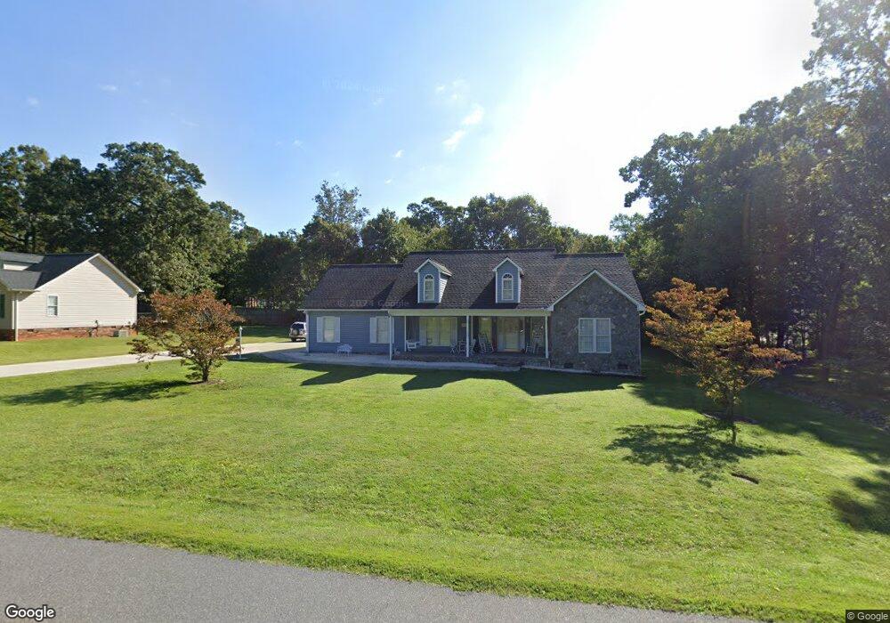
4700 Ransom Dr Conover, NC 28613
Estimated Value: $354,875 - $409,000
3
Beds
2
Baths
2,215
Sq Ft
$171/Sq Ft
Est. Value
About This Home
This home is located at 4700 Ransom Dr, Conover, NC 28613 and is currently estimated at $377,969, approximately $170 per square foot. 4700 Ransom Dr is a home located in Catawba County with nearby schools including Saint Stephens High School, Snow Creek Elementary School, and Harry M. Arndt Middle School.
Ownership History
Date
Name
Owned For
Owner Type
Purchase Details
Closed on
Apr 4, 2024
Sold by
Dennis M Rice M and Dennis Glenda W
Bought by
Dennis And Glenda Rice Revocable Living Trust
Current Estimated Value
Purchase Details
Closed on
Feb 25, 2005
Sold by
Rice Dennis M and Rice Glenda W
Bought by
Rice Dennis M and Rice Glenda W
Purchase Details
Closed on
Oct 18, 2002
Bought by
Bumgarner Dennis Carroll
Purchase Details
Closed on
Jun 7, 2002
Create a Home Valuation Report for This Property
The Home Valuation Report is an in-depth analysis detailing your home's value as well as a comparison with similar homes in the area
Home Values in the Area
Average Home Value in this Area
Purchase History
| Date | Buyer | Sale Price | Title Company |
|---|---|---|---|
| Dennis And Glenda Rice Revocable Living Trust | -- | None Listed On Document | |
| Rice Dennis M | -- | None Available | |
| Bumgarner Dennis Carroll | $205,000 | -- | |
| -- | $20,000 | -- |
Source: Public Records
Tax History
| Year | Tax Paid | Tax Assessment Tax Assessment Total Assessment is a certain percentage of the fair market value that is determined by local assessors to be the total taxable value of land and additions on the property. | Land | Improvement |
|---|---|---|---|---|
| 2025 | $2,174 | $320,500 | $15,000 | $305,500 |
| 2024 | $1,675 | $320,500 | $15,000 | $305,500 |
| 2023 | $1,611 | $221,800 | $15,000 | $206,800 |
| 2022 | $1,542 | $221,800 | $15,000 | $206,800 |
| 2021 | $1,542 | $221,800 | $15,000 | $206,800 |
| 2020 | $1,542 | $221,800 | $15,000 | $206,800 |
| 2019 | $1,542 | $221,800 | $0 | $0 |
| 2018 | $0 | $187,800 | $15,000 | $172,800 |
| 2017 | $1,305 | $0 | $0 | $0 |
| 2016 | $1,305 | $0 | $0 | $0 |
| 2015 | $1,353 | $187,790 | $15,000 | $172,790 |
| 2014 | $1,353 | $225,500 | $16,400 | $209,100 |
Source: Public Records
Map
Nearby Homes
- 4687 Ransom Dr
- 2056 Sipe Rd
- 5217 Canterbury Dr
- 1098 Remington Dr
- 4363 Section House Rd
- 4434 Steeple Chase Dr
- 4484 Springs Rd
- 3410 25th Ave NE
- 4051 Plum St
- 4645 Rifle Range Rd
- 1949 Colonial Ln
- 5505 Creek Point Dr
- 1158 Sunset Ct
- 1802 33rd St NE
- 3835 Sulphur Springs Rd NE
- 2918 23rd Ave NE
- 3321 39th Avenue Ct NE Unit 5
- 1246 Houston Mill Rd
- 1922 30th St NE
- 4874 Stone Dr Unit 125
Your Personal Tour Guide
Ask me questions while you tour the home.