Estimated Value: $369,000 - $403,000
2
Beds
2
Baths
864
Sq Ft
$441/Sq Ft
Est. Value
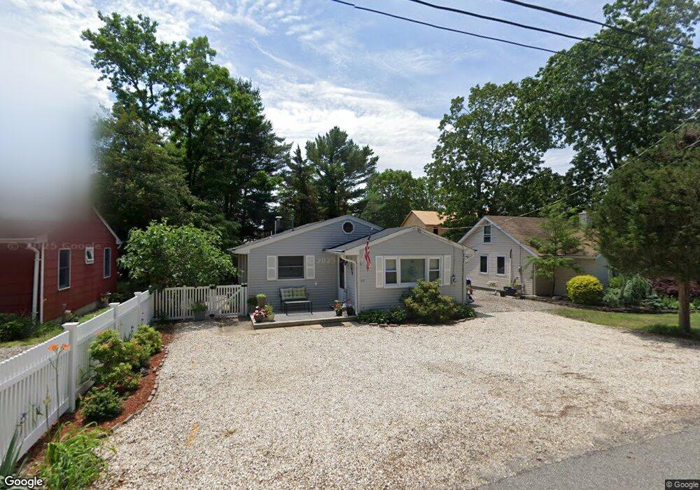
About This Home
This home is located at 471 Burnt Bark Rd, Brick, NJ 08723 and is currently estimated at $380,942, approximately $440 per square foot. 471 Burnt Bark Rd is a home located in Ocean County with nearby schools including Emma Havens Young Elementary School, Lake Riviera Middle School, and Brick Township High School.
Ownership History
Date
Name
Owned For
Owner Type
Purchase Details
Closed on
Mar 20, 2020
Sold by
Fritz Kristine and Estate Of John F Turner
Bought by
Fritz Kristine and Turner David John
Current Estimated Value
Purchase Details
Closed on
Aug 14, 2003
Sold by
Zdanowsicz Stephan
Bought by
Turner John and Danke Frances
Home Financials for this Owner
Home Financials are based on the most recent Mortgage that was taken out on this home.
Original Mortgage
$125,000
Interest Rate
5.52%
Purchase Details
Closed on
Aug 11, 2003
Sold by
Zdanowicz Stephan
Bought by
Turner John and Danke Frances M
Home Financials for this Owner
Home Financials are based on the most recent Mortgage that was taken out on this home.
Original Mortgage
$125,000
Interest Rate
5.52%
Purchase Details
Closed on
Oct 14, 1999
Sold by
Kotz Ronald
Bought by
Zdanowicz Stephan
Home Financials for this Owner
Home Financials are based on the most recent Mortgage that was taken out on this home.
Original Mortgage
$67,170
Interest Rate
7.78%
Create a Home Valuation Report for This Property
The Home Valuation Report is an in-depth analysis detailing your home's value as well as a comparison with similar homes in the area
Home Values in the Area
Average Home Value in this Area
Purchase History
| Date | Buyer | Sale Price | Title Company |
|---|---|---|---|
| Fritz Kristine | -- | None Available | |
| Turner John | $175,000 | -- | |
| Turner John | $175,000 | -- | |
| Zdanowicz Stephan | $69,250 | First American Title Ins Co |
Source: Public Records
Mortgage History
| Date | Status | Borrower | Loan Amount |
|---|---|---|---|
| Previous Owner | Turner John | $125,000 | |
| Previous Owner | Zdanowicz Stephan | $67,170 |
Source: Public Records
Tax History Compared to Growth
Tax History
| Year | Tax Paid | Tax Assessment Tax Assessment Total Assessment is a certain percentage of the fair market value that is determined by local assessors to be the total taxable value of land and additions on the property. | Land | Improvement |
|---|---|---|---|---|
| 2025 | $4,959 | $192,000 | $125,000 | $67,000 |
| 2024 | $4,714 | $192,000 | $125,000 | $67,000 |
| 2023 | $4,652 | $192,000 | $125,000 | $67,000 |
| 2022 | $4,652 | $192,000 | $125,000 | $67,000 |
| 2021 | $4,554 | $192,000 | $125,000 | $67,000 |
| 2020 | $4,497 | $192,000 | $125,000 | $67,000 |
| 2019 | $4,422 | $192,000 | $125,000 | $67,000 |
| 2018 | $4,320 | $192,000 | $125,000 | $67,000 |
| 2017 | $4,203 | $192,000 | $125,000 | $67,000 |
| 2016 | $4,182 | $192,000 | $125,000 | $67,000 |
| 2015 | $4,072 | $192,000 | $125,000 | $67,000 |
| 2014 | $4,040 | $192,000 | $125,000 | $67,000 |
Source: Public Records
Map
Nearby Homes
- 474 Burnt Bark Rd
- 470 Mantoloking Rd
- 0 Mantoloking Rd Unit 11584872
- 495 Pinecroft Dr
- 507 Riverside Dr S
- 82 E View Dr
- 10 Riverside Dr W
- 53 Country Club Ct
- 484 Bara St
- 15 Hulse Landing Rd
- 00 Mantoloking Rd
- VZ0 Mantoloking Rd
- 553 Kingfisher Cr
- 553 Kingfisher Cir
- 570 Mantoloking Rd
- 417 Mamie Dr
- 463 Mamie Dr
- 455 Mamie Dr
- 595 Kingfisher Cir
- 42 Arbutus Ave
- 469 Burnt Bark Rd
- 475 Burnt Bark Rd
- 470 Pinecroft Dr
- 467 Burnt Bark Rd
- 472 Pinecroft Dr
- 468 Pinecroft Dr
- 468 Burnt Bark Rd
- 472 Burnt Bark Rd
- 476 Pinecroft Dr
- 465 Burnt Bark Rd
- 464 Pinecroft Dr
- 466 Burnt Bark Rd
- 479 Burnt Bark Rd
- 464 Burnt Bark Rd
- 463 Burnt Bark Rd
- 480 Pinecroft Dr
- 462 Pinecroft Dr
- 473 Pinecroft Dr
- 473 Augustus Rd
- 471 Pinecroft Dr