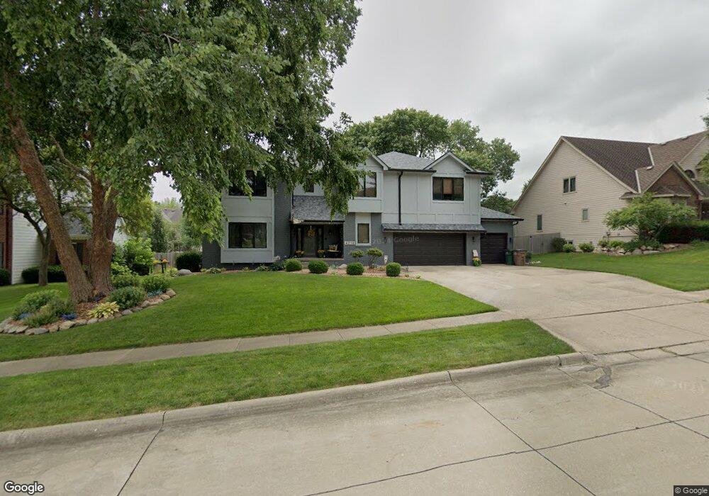
4712 Colt Dr West Des Moines, IA 50265
Estimated Value: $687,000 - $792,000
4
Beds
5
Baths
4,057
Sq Ft
$180/Sq Ft
Est. Value
About This Home
This home is located at 4712 Colt Dr, West Des Moines, IA 50265 and is currently estimated at $729,122, approximately $179 per square foot. 4712 Colt Dr is a home located in Polk County with nearby schools including Crossroads Park Elementary School, Indian Hills Junior High School, and Valley Southwoods Freshman High School.
Ownership History
Date
Name
Owned For
Owner Type
Purchase Details
Closed on
Sep 20, 2013
Sold by
Long John A and Long Sally A
Bought by
Maher Thomas Patrick and Maher Megan Schultz
Current Estimated Value
Home Financials for this Owner
Home Financials are based on the most recent Mortgage that was taken out on this home.
Original Mortgage
$315,000
Interest Rate
4.39%
Purchase Details
Closed on
Jul 20, 2000
Sold by
Long John A and Long Sally A
Bought by
Long John A and Long Sally A
Create a Home Valuation Report for This Property
The Home Valuation Report is an in-depth analysis detailing your home's value as well as a comparison with similar homes in the area
Home Values in the Area
Average Home Value in this Area
Purchase History
| Date | Buyer | Sale Price | Title Company |
|---|---|---|---|
| Maher Thomas Patrick | $433,000 | None Available | |
| Long John A | -- | -- |
Source: Public Records
Mortgage History
| Date | Status | Borrower | Loan Amount |
|---|---|---|---|
| Closed | Maher Thomas Patrick | $315,000 |
Source: Public Records
Tax History Compared to Growth
Tax History
| Year | Tax Paid | Tax Assessment Tax Assessment Total Assessment is a certain percentage of the fair market value that is determined by local assessors to be the total taxable value of land and additions on the property. | Land | Improvement |
|---|---|---|---|---|
| 2025 | $9,954 | $683,400 | $120,200 | $563,200 |
| 2024 | $9,954 | $628,000 | $108,800 | $519,200 |
| 2023 | $10,086 | $628,000 | $108,800 | $519,200 |
| 2022 | $9,966 | $522,300 | $93,900 | $428,400 |
| 2021 | $9,794 | $522,300 | $93,900 | $428,400 |
| 2020 | $9,648 | $488,400 | $87,700 | $400,700 |
| 2019 | $9,034 | $488,400 | $87,700 | $400,700 |
| 2018 | $9,056 | $441,000 | $77,800 | $363,200 |
| 2017 | $9,250 | $441,000 | $77,800 | $363,200 |
| 2016 | $9,050 | $437,600 | $76,000 | $361,600 |
| 2015 | $9,050 | $437,600 | $76,000 | $361,600 |
| 2014 | $8,442 | $425,200 | $73,400 | $351,800 |
Source: Public Records
Map
Nearby Homes
- 4600 Aspen Dr
- 5005 Colt Dr
- 636 47th St
- 4817 Westbrooke Place
- 4917 Westbrooke Place
- 4830 Cedar Dr Unit 86
- 5101 Dakota Dr
- 4906 W Park Dr Unit J2
- 4918 W Park Dr Unit G3
- 5207 Pommel Place
- 4300 Pommel Place
- 521 51st St
- 942 42nd St
- 1112 49th St Unit 2
- 1124 49th St Unit 2
- 4609 Woodland Ave Unit 5
- 513 52nd St
- 5242 Dakota Dr
- 1168 49th St Unit 1
- 756 Knolls Ct
- 4720 Colt Dr
- 4706 Colt Dr
- 4713 Brookview Dr
- 4717 Brookview Dr
- 4701 Brookview Dr
- 4717 Colt Dr
- 805 48th St
- 4713 Colt Dr
- 901 48th St
- 4721 Brookview Dr
- 4705 Colt Dr
- 4701 Colt Dr
- 905 48th St
- 4712 Brookview Dr
- 4716 Brookview Dr
- 4700 Brookview Dr
- 4704 Brookview Dr
- 4708 Brookview Dr
- 4720 Brookview Dr
- 804 48th St