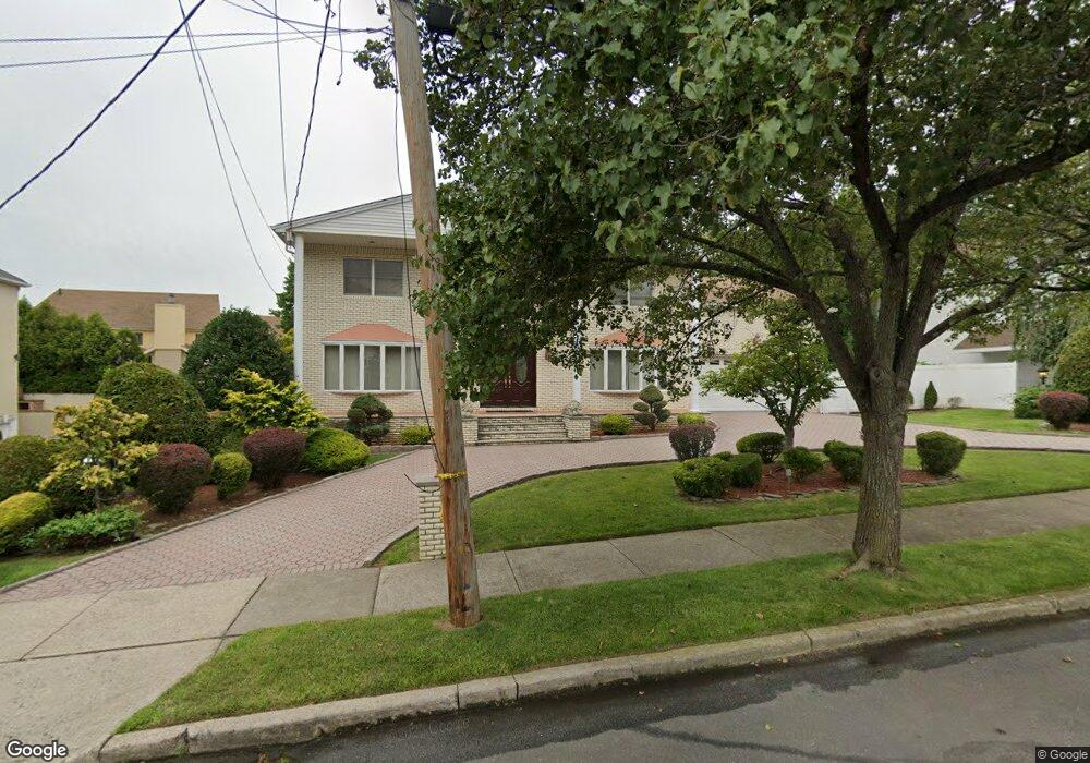
472 Harold Ave Staten Island, NY 10312
Annadale NeighborhoodEstimated Value: $1,168,960 - $1,982,000
5
Beds
3
Baths
3,020
Sq Ft
$473/Sq Ft
Est. Value
About This Home
This home is located at 472 Harold Ave, Staten Island, NY 10312 and is currently estimated at $1,427,990, approximately $472 per square foot. 472 Harold Ave is a home located in Richmond County with nearby schools including P.S. 55 The Henry M. Boehm School, I.S. 007 Elias Bernstein, and Tottenville High School.
Ownership History
Date
Name
Owned For
Owner Type
Purchase Details
Closed on
Feb 28, 2024
Sold by
Zhang Pu and Cheng Yuan Chao
Bought by
Pu Zhang And Yuan Chao Cheng Family Legacy Tr and Zhang
Current Estimated Value
Purchase Details
Closed on
Jul 31, 2001
Sold by
Albano Rita A and Tardio Rita A
Bought by
Zhang Pu and Cheng Yuan Chao
Home Financials for this Owner
Home Financials are based on the most recent Mortgage that was taken out on this home.
Original Mortgage
$275,000
Interest Rate
7.05%
Purchase Details
Closed on
Apr 18, 1997
Sold by
Tardio Julio A and Tardio Rita A
Bought by
Tardio Rita A
Create a Home Valuation Report for This Property
The Home Valuation Report is an in-depth analysis detailing your home's value as well as a comparison with similar homes in the area
Home Values in the Area
Average Home Value in this Area
Purchase History
| Date | Buyer | Sale Price | Title Company |
|---|---|---|---|
| Pu Zhang And Yuan Chao Cheng Family Legacy Tr | -- | Stewart Title | |
| Zhang Pu | $685,000 | Stewart Title Insurance Co | |
| Tardio Rita A | $275,000 | Commonwealth Land Title Ins |
Source: Public Records
Mortgage History
| Date | Status | Borrower | Loan Amount |
|---|---|---|---|
| Previous Owner | Zhang Pu | $275,000 |
Source: Public Records
Tax History Compared to Growth
Tax History
| Year | Tax Paid | Tax Assessment Tax Assessment Total Assessment is a certain percentage of the fair market value that is determined by local assessors to be the total taxable value of land and additions on the property. | Land | Improvement |
|---|---|---|---|---|
| 2025 | $11,715 | $69,720 | $20,661 | $49,059 |
| 2024 | $11,715 | $64,200 | $21,259 | $42,941 |
| 2023 | $11,175 | $55,026 | $17,433 | $37,593 |
| 2022 | $9,835 | $61,980 | $23,400 | $38,580 |
| 2021 | $10,796 | $51,300 | $23,400 | $27,900 |
| 2020 | $10,906 | $56,520 | $23,400 | $33,120 |
| 2019 | $10,168 | $61,320 | $23,400 | $37,920 |
| 2018 | $9,348 | $45,855 | $18,119 | $27,736 |
| 2017 | $8,819 | $43,260 | $23,400 | $19,860 |
| 2016 | $9,632 | $48,180 | $23,400 | $24,780 |
| 2015 | $9,868 | $51,420 | $19,500 | $31,920 |
| 2014 | $9,868 | $51,420 | $19,500 | $31,920 |
Source: Public Records
Map
Nearby Homes
- 440 Harold Ave
- 192 Bathgate St
- 62 Bennett Place
- 422 Harold Ave
- 456 Holdridge Ave
- 41 Bennett Place
- 155 Bathgate St
- 27 Mayberry Promenade
- 69 Elmbank St
- 4826 Hylan Blvd
- 705 Barclay Ave
- 47 Ravenna St
- 750 Barclay Ave
- 97 Kinghorn St
- 161 Boardwalk Ave
- 330 Shirley Ave
- 15 Lenzie St
- 262 Noel St
- 31 4th Ct
- 488 King St
- 464 Harold Ave
- 482 Harold Ave
- 115 Bennett Place
- 115 Bennett Ave Unit 66B
- 115 Bennett Ave
- 105 Bennett Place Unit 1a
- 105 Bennett Place
- 125 Bennett Place
- 467 Harold Ave
- 469 Harold Ave
- 490 Harold Ave
- 457 Harold Ave
- 133 Bennett Place
- 39 Sandgap St
- 44 Sandgap St
- 37 Sandgap St
- 4684 Hylan Blvd
- 4711 Hylan Blvd
- 120A Bennett Place
- 106 Bennett Place