


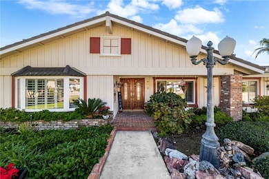

472 W 23rd St Upland, CA 91784
Estimated payment $6,434/month
Highlights
- Very Popular Property
- In Ground Pool
- City Lights View
- Valencia Elementary Rated A-
- Primary Bedroom Suite
- 0.46 Acre Lot
About This Home
Welcome to 472 W. 23rd Street, a beautifully maintained single-story home nestled in the highly desired city of Upland. Situated on an expansive half-acre lot, this property showcases breathtaking mountain views and an exceptional blend of comfort, space, and outdoor enjoyment. This charming 4-bedroom, 2-bath residence has been thoughtfully updated over the years. Step inside to discover an inviting open and spacious floor plan featuring high ceilings in the living room, dining room, family room, and kitchen—perfect for modern living and entertaining. The home boasts numerous upgrades, including dual-pane windows, wood shutters, updated flooring, and remodeled bathrooms. The exterior is equally impressive with a sparkling pool and spa, basketball area, and a huge RV side yard. The attached two-car garage offers convenience and includes a full pass-through (crew) door. Outdoors, enjoy a large covered patio, built-in BBQ, and lush landscaping accented by mature fruit trees—an ideal setting for gatherings or peaceful relaxation. The circular driveway provides ample parking for multiple vehicles, and the generous lot offers plenty of room for an ADU. Truly move-in ready, this home is a rare find offering space, privacy, and resort-style amenities—all in one of Upland’s most scenic neighborhoods. Don’t miss your chance to make this exceptional property your own!
Listing Agent
Elevate Real Estate Agency Brokerage Phone: 626-622-8511 License #01406869 Listed on: 12/09/2025
Co-Listing Agent
Elevate Real Estate Agency Brokerage Phone: 626-622-8511 License #01972899
Open House Schedule
-
Saturday, December 13, 202512:00 to 3:00 pm12/13/2025 12:00:00 PM +00:0012/13/2025 3:00:00 PM +00:00Add to Calendar
-
Sunday, December 14, 202512:00 to 3:00 pm12/14/2025 12:00:00 PM +00:0012/14/2025 3:00:00 PM +00:00Add to Calendar
Home Details
Home Type
- Single Family
Year Built
- Built in 1968
Lot Details
- 0.46 Acre Lot
- Lawn
- Back and Front Yard
Parking
- 2 Car Attached Garage
Property Views
- City Lights
- Mountain
- Neighborhood
Home Design
- Entry on the 1st floor
Interior Spaces
- 2,111 Sq Ft Home
- 1-Story Property
- Family Room Off Kitchen
- Living Room with Fireplace
- Dining Room
Kitchen
- Open to Family Room
- Breakfast Bar
- Electric Range
- Microwave
- Dishwasher
Flooring
- Carpet
- Laminate
Bedrooms and Bathrooms
- 4 Main Level Bedrooms
- Primary Bedroom Suite
- Remodeled Bathroom
- 2 Full Bathrooms
Laundry
- Laundry Room
- Laundry in Garage
Pool
- In Ground Pool
- In Ground Spa
Outdoor Features
- Covered Patio or Porch
- Exterior Lighting
Utilities
- Central Heating and Cooling System
- Tankless Water Heater
Community Details
- No Home Owners Association
Listing and Financial Details
- Tax Lot 52
- Tax Tract Number 7289
- Assessor Parcel Number 1043262260000
- $453 per year additional tax assessments
Map
Home Values in the Area
Average Home Value in this Area
Tax History
| Year | Tax Paid | Tax Assessment Tax Assessment Total Assessment is a certain percentage of the fair market value that is determined by local assessors to be the total taxable value of land and additions on the property. | Land | Improvement |
|---|---|---|---|---|
| 2025 | $4,683 | $438,621 | $153,518 | $285,103 |
| 2024 | $4,683 | $430,021 | $150,508 | $279,513 |
| 2023 | $4,611 | $421,589 | $147,557 | $274,032 |
| 2022 | $4,510 | $413,323 | $144,664 | $268,659 |
| 2021 | $4,503 | $405,218 | $141,827 | $263,391 |
| 2020 | $4,380 | $401,063 | $140,373 | $260,690 |
| 2019 | $4,364 | $393,199 | $137,621 | $255,578 |
| 2018 | $4,257 | $385,490 | $134,923 | $250,567 |
| 2017 | $4,133 | $377,931 | $132,277 | $245,654 |
| 2016 | $3,924 | $370,520 | $129,683 | $240,837 |
| 2015 | $3,834 | $364,954 | $127,735 | $237,219 |
| 2014 | $3,734 | $357,805 | $125,233 | $232,572 |
Property History
| Date | Event | Price | List to Sale | Price per Sq Ft |
|---|---|---|---|---|
| 12/09/2025 12/09/25 | For Sale | $1,149,000 | -- | $544 / Sq Ft |
Purchase History
| Date | Type | Sale Price | Title Company |
|---|---|---|---|
| Interfamily Deed Transfer | -- | None Available |
Source: California Regional Multiple Listing Service (CRMLS)
MLS Number: CV25273405
APN: 1043-262-26
Disclaimer: Certain information contained herein is derived from information provided by parties other than Homes.com. All information provided is deemed reliable, but is not guaranteed to be accurate and should be independently verified.
![]() The multiple listing data appearing on this website, or contained in reports produced therefrom, is owned and copyrighted by California Regional Multiple Listing Service, Inc. ("CRMLS") and is protected by all applicable copyright laws. Information provided is for viewer's personal, non-commercial use and may not be used for any purpose other than to identify prospective properties the viewer may be interested in purchasing. All listing data, including but not limited to square footage and lot size is believed to be accurate, but the listing Agent, listing Broker and CRMLS and its affiliates do not warrant or guarantee such accuracy. The viewer should independently verify the listed data prior to making any decisions based on such information by personal inspection and/or contacting a real estate professional.
The multiple listing data appearing on this website, or contained in reports produced therefrom, is owned and copyrighted by California Regional Multiple Listing Service, Inc. ("CRMLS") and is protected by all applicable copyright laws. Information provided is for viewer's personal, non-commercial use and may not be used for any purpose other than to identify prospective properties the viewer may be interested in purchasing. All listing data, including but not limited to square footage and lot size is believed to be accurate, but the listing Agent, listing Broker and CRMLS and its affiliates do not warrant or guarantee such accuracy. The viewer should independently verify the listed data prior to making any decisions based on such information by personal inspection and/or contacting a real estate professional.
Based on information from California Regional Multiple Listing Service, Inc. and /or other sources. All data, including all measurements and calculations of area, is obtained from various sources and has not been, and will not be, verified by broker or MLS. All information should be independently reviewed and verified for accuracy. Properties may or may not be listed by the office/agent presenting the information
- 2335 N San Antonio Ave
- 211 Deborah Ct
- 785 W Dalton Ct
- 0 Vista Dr
- 2419 San Antonio Crescent W
- 2162 N Euclid Ave
- 141 W 21st St
- 2497 Sierra Dr
- 275 E 24th St
- 2246 N Kelly Ave
- 2376 Sunset Curve
- 2360 N Mountain Ave
- 2445 Ocean View Dr
- 1221 Hibiscus St
- 1252 Granada St
- 2464 Prospect Dr
- 1124 Peppertree Ln
- 1214 Miller Ct
- 1230 Piedmont Dr
- 2166 Malati Cir
- 681 Kenwood St Unit 681
- 2286 Willow Ave
- 2215 Lobelia Ave
- 723 Heritage Ln
- 712 Highline Way
- 1682 Colfax Way
- 775 Falcon View St
- 1162 E 19th St
- 1683 N Mountain Ave Unit A
- 1605 Carmel Cir E
- 1228 Scenic View St
- 657 W 14th St
- 1447 N Mountain Ave
- 1501 Golf Club Dr
- 683 Pacific Ct
- 1397 N 3rd Ave
- 1047 Pomello Dr
- 8654 Vicara Dr
- 8479 Avalon Ct
- 4176 New Hampshire Ave
