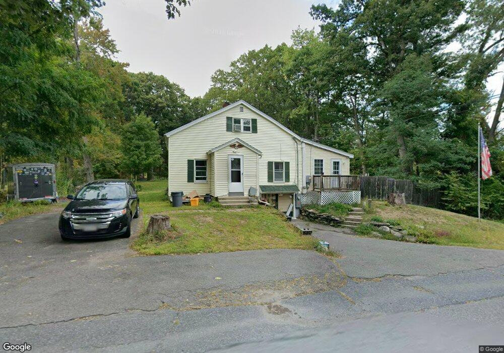
473 Massachusetts Ave Lunenburg, MA 01462
Estimated Value: $349,000 - $386,000
3
Beds
1
Bath
1,120
Sq Ft
$330/Sq Ft
Est. Value
About This Home
This home is located at 473 Massachusetts Ave, Lunenburg, MA 01462 and is currently estimated at $369,397, approximately $329 per square foot. 473 Massachusetts Ave is a home located in Worcester County with nearby schools including Lunenburg Primary School, Lunenburg High School, and St Bernards Elementary School.
Ownership History
Date
Name
Owned For
Owner Type
Purchase Details
Closed on
Jul 30, 2003
Sold by
Langlois Andrew G
Bought by
Brady Donna M and Brady Joseph W
Current Estimated Value
Home Financials for this Owner
Home Financials are based on the most recent Mortgage that was taken out on this home.
Original Mortgage
$150,000
Outstanding Balance
$64,416
Interest Rate
5.28%
Mortgage Type
Purchase Money Mortgage
Estimated Equity
$304,981
Create a Home Valuation Report for This Property
The Home Valuation Report is an in-depth analysis detailing your home's value as well as a comparison with similar homes in the area
Home Values in the Area
Average Home Value in this Area
Purchase History
| Date | Buyer | Sale Price | Title Company |
|---|---|---|---|
| Brady Donna M | $160,000 | -- |
Source: Public Records
Mortgage History
| Date | Status | Borrower | Loan Amount |
|---|---|---|---|
| Open | Brady Donna M | $150,000 |
Source: Public Records
Tax History Compared to Growth
Tax History
| Year | Tax Paid | Tax Assessment Tax Assessment Total Assessment is a certain percentage of the fair market value that is determined by local assessors to be the total taxable value of land and additions on the property. | Land | Improvement |
|---|---|---|---|---|
| 2025 | $4,167 | $290,200 | $99,400 | $190,800 |
| 2024 | $3,886 | $275,600 | $93,700 | $181,900 |
| 2023 | $3,952 | $270,300 | $88,400 | $181,900 |
| 2022 | $3,541 | $206,000 | $73,700 | $132,300 |
| 2020 | $3,376 | $186,300 | $73,800 | $112,500 |
| 2019 | $3,105 | $166,200 | $61,000 | $105,200 |
| 2018 | $3,115 | $158,100 | $71,900 | $86,200 |
| 2017 | $2,813 | $140,800 | $58,900 | $81,900 |
| 2016 | $2,791 | $142,300 | $62,000 | $80,300 |
| 2015 | $2,499 | $136,400 | $58,900 | $77,500 |
Source: Public Records
Map
Nearby Homes
- 77 Electric Ave
- 77 Upland Ave
- 711 Massachusetts Ave Unit 2
- 6 Riley Rd Unit 6
- 23 Tilton Ave
- 756 Northfield Rd
- 1083 Northfield Rd
- 759 Northfield Rd
- 319 Highland St
- 63 Holman St
- 200-365 Hollis Rd
- 665 Townsend St
- 29 West St
- 31 School St
- 62 Shawna St
- 452 Hollis Rd
- 9 Pleasant St
- 141 Pleasant St
- 9 Fairview Rd
- 474 Townsend St
- 467 Massachusetts Ave
- 481 Massachusetts Ave
- 474 Massachusetts Ave
- 460 Massachusetts Ave
- 493 Massachusetts Ave
- 466 Massachusetts Ave
- 496 Massachusetts Ave
- 496 Mass Ave
- 54 Chase Rd
- 506 Massachusetts Ave
- 45 Chase Rd
- 45 Chase Rd
- 15 Hollis Rd Unit 148
- 512 Massachusetts Ave
- 33 Hollis Rd
- 23 Hollis Rd Unit 25
- 53 Chase Rd
- 31 Chase Rd
- 101 Beal St
- 1 Chase Rd Unit L