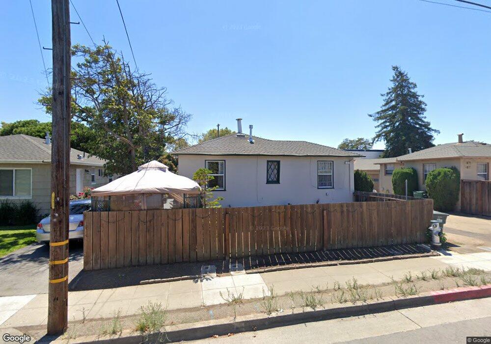
473 Rollins Rd Burlingame, CA 94010
Oak Grove Manor NeighborhoodEstimated Value: $1,432,000 - $2,403,050
4
Beds
2
Baths
1,978
Sq Ft
$1,023/Sq Ft
Est. Value
About This Home
This home is located at 473 Rollins Rd, Burlingame, CA 94010 and is currently estimated at $2,022,763, approximately $1,022 per square foot. 473 Rollins Rd is a home located in San Mateo County with nearby schools including Washington Elementary School, Burlingame Intermediate School, and Burlingame High School.
Ownership History
Date
Name
Owned For
Owner Type
Purchase Details
Closed on
Jan 17, 2018
Sold by
Morsello Veronica and Morsello Lawrence
Bought by
Chung Amy and Kim Francis
Current Estimated Value
Purchase Details
Closed on
Jun 9, 2016
Sold by
Morsello Veronica
Bought by
Morsello Lawrence Gerald and Morsello Veronica Collen Falcon
Purchase Details
Closed on
Apr 6, 2011
Sold by
Morsello Veronica
Bought by
Morsello Veronica and Miller Victoria
Purchase Details
Closed on
Dec 14, 2010
Sold by
Morsello Veronica
Bought by
Morsello Veronica and Miller Victoria
Create a Home Valuation Report for This Property
The Home Valuation Report is an in-depth analysis detailing your home's value as well as a comparison with similar homes in the area
Home Values in the Area
Average Home Value in this Area
Purchase History
| Date | Buyer | Sale Price | Title Company |
|---|---|---|---|
| Chung Amy | -- | None Available | |
| Morsello Lawrence Gerald | -- | None Available | |
| Morsello Veronica | -- | None Available | |
| Morsello Veronica | -- | None Available |
Source: Public Records
Tax History
| Year | Tax Paid | Tax Assessment Tax Assessment Total Assessment is a certain percentage of the fair market value that is determined by local assessors to be the total taxable value of land and additions on the property. | Land | Improvement |
|---|---|---|---|---|
| 2025 | $5,626 | $464,416 | $139,313 | $325,103 |
| 2023 | $5,626 | $446,384 | $133,904 | $312,480 |
| 2022 | $5,433 | $437,632 | $131,279 | $306,353 |
| 2021 | $5,436 | $429,052 | $128,705 | $300,347 |
| 2020 | $5,324 | $424,654 | $127,386 | $297,268 |
| 2019 | $5,215 | $416,329 | $124,889 | $291,440 |
| 2018 | $5,120 | $408,167 | $122,441 | $285,726 |
| 2017 | $5,082 | $400,165 | $120,041 | $280,124 |
| 2016 | $4,897 | $392,320 | $117,688 | $274,632 |
| 2015 | $4,873 | $386,428 | $115,921 | $270,507 |
| 2014 | $4,805 | $378,860 | $113,651 | $265,209 |
Source: Public Records
Map
Nearby Homes
- 200 Anita Rd
- 728 Laurel Ave
- 39 Victoria Rd
- 808 Winchester Dr
- 748 Laurel Ave
- 10 Channing Rd
- 422 Peninsula Ave
- 869 Woodside Way
- 320 Peninsula Ave Unit 409
- 320 Peninsula Ave Unit 316
- 737 Linden Ave
- 815 N Humboldt St Unit 508
- 932 Peninsula Ave Unit 406
- 821 N Humboldt St Unit 309
- 833 N Humboldt St Unit 201
- 934 Peninsula Ave Unit 301
- 835 N Humboldt St Unit 203
- 800 N Delaware St Unit 303
- 816 N Delaware St Unit 409
- 820 N Delaware St Unit 215
- 477 Rollins Rd
- 469 Rollins Rd
- 479 Rollins Rd
- 465 Rollins Rd
- 384 Lexington Way
- 376 Lexington Way
- 485 Rollins Rd
- 461 Rollins Rd
- 390 Lexington Way
- 372 Lexington Way
- 455 Rollins Rd
- 489 Rollins Rd
- 418 Dwight Rd
- 424 Dwight Rd
- 416 Dwight Rd
- 491 Rollins Rd
- 428 Dwight Rd
- 366 Lexington Way
- 394 Lexington Way
- 434 Dwight Rd
Your Personal Tour Guide
Ask me questions while you tour the home.