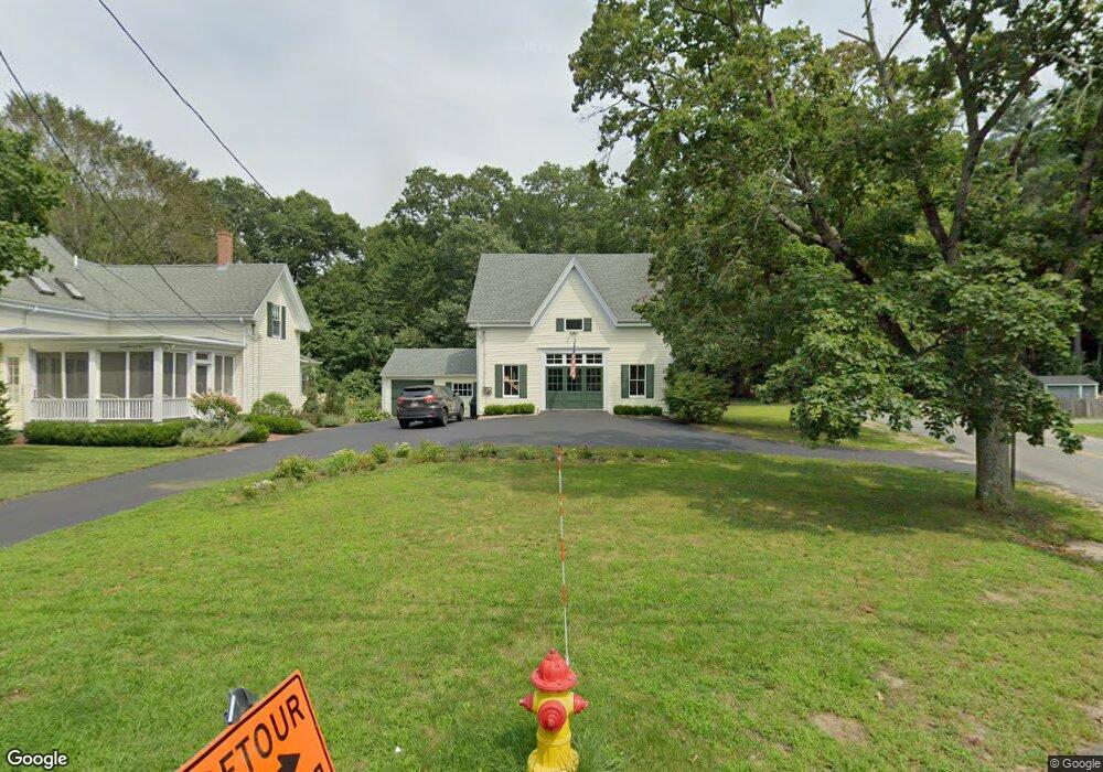
474 State St Hanson, MA 02341
Estimated Value: $619,021 - $736,000
3
Beds
2
Baths
2,051
Sq Ft
$326/Sq Ft
Est. Value
About This Home
This home is located at 474 State St, Hanson, MA 02341 and is currently estimated at $668,255, approximately $325 per square foot. 474 State St is a home located in Plymouth County with nearby schools including Cadence Academy Preschool - Hanover and Cardinal Cushing Centers.
Ownership History
Date
Name
Owned For
Owner Type
Purchase Details
Closed on
Feb 20, 2019
Sold by
Bergeron Lee R and Bergeron Kathleen
Bought by
Bergeron Ft
Current Estimated Value
Purchase Details
Closed on
Jul 17, 1997
Sold by
Nature Conservancy
Bought by
Warren Ethan and Warren Linda B
Purchase Details
Closed on
Aug 9, 1996
Sold by
Thamalis Frixon
Bought by
Nature Conservancy
Create a Home Valuation Report for This Property
The Home Valuation Report is an in-depth analysis detailing your home's value as well as a comparison with similar homes in the area
Home Values in the Area
Average Home Value in this Area
Purchase History
| Date | Buyer | Sale Price | Title Company |
|---|---|---|---|
| Bergeron Ft | -- | -- | |
| Warren Ethan | $40,000 | -- | |
| Nature Conservancy | $75,000 | -- | |
| Nature Conservancy | $75,000 | -- |
Source: Public Records
Mortgage History
| Date | Status | Borrower | Loan Amount |
|---|---|---|---|
| Previous Owner | Nature Conservancy | $40,000 | |
| Previous Owner | Nature Conservancy | $50,000 |
Source: Public Records
Tax History
| Year | Tax Paid | Tax Assessment Tax Assessment Total Assessment is a certain percentage of the fair market value that is determined by local assessors to be the total taxable value of land and additions on the property. | Land | Improvement |
|---|---|---|---|---|
| 2025 | $7,015 | $524,300 | $194,600 | $329,700 |
| 2024 | $6,810 | $509,000 | $188,900 | $320,100 |
| 2023 | $6,684 | $471,400 | $188,900 | $282,500 |
| 2022 | $6,469 | $428,700 | $171,700 | $257,000 |
| 2021 | $5,881 | $389,500 | $165,200 | $224,300 |
| 2020 | $5,506 | $360,600 | $159,500 | $201,100 |
| 2019 | $5,313 | $342,100 | $156,500 | $185,600 |
| 2018 | $4,493 | $283,800 | $150,500 | $133,300 |
| 2017 | $4,374 | $273,700 | $143,300 | $130,400 |
| 2016 | $4,472 | $270,200 | $143,300 | $126,900 |
| 2015 | $4,276 | $268,600 | $143,300 | $125,300 |
Source: Public Records
Map
Nearby Homes
- 339 State St
- 430 Brook Bend Rd
- 114 Graham Hill Dr
- 51 Farmside Dr
- 108 Waterford Dr
- 7 Farmside Dr
- 285 W Elm St
- 139 Fairwood Dr
- 60 Summer Path Way
- 35 Sproul Rd
- 51 Cervelli Farm Dr
- 37 Dr
- 23 Cervelli Farm Dr
- 38 Cervelli Farm Dr
- 9 Cervelli Farm Dr
- 250 Center St
- 26 Stonebridge Dr
- 95 Tecumseh Dr
- 127 Crescent Place
- 269 Lakeside Rd
- 458 State St
- 1099 E Washington St
- 1101 E Washington St
- 498 State St
- 436 State St
- 445 State St
- 1114 E Washington St
- 1162 E Washington St
- 508 State St
- 1175 E Washington St
- 499 State St
- 1098 E Washington St
- 1087 E Washington St
- 422 State St
- 1178 E Washington St
- 520 State St
- 544 State St
- 517 State St
- 435 State St
- 1084 E Washington St
Your Personal Tour Guide
Ask me questions while you tour the home.