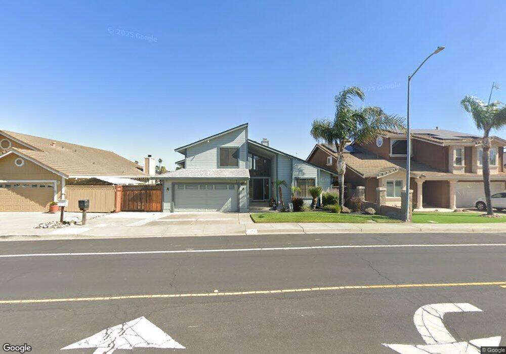
4741 Clipper Dr Discovery Bay, CA 94505
Estimated Value: $839,266 - $1,180,000
3
Beds
3
Baths
2,563
Sq Ft
$383/Sq Ft
Est. Value
About This Home
This home is located at 4741 Clipper Dr, Discovery Bay, CA 94505 and is currently estimated at $982,817, approximately $383 per square foot. 4741 Clipper Dr is a home located in Contra Costa County with nearby schools including Discovery Bay Elementary School, Excelsior Middle School, and Liberty High School.
Ownership History
Date
Name
Owned For
Owner Type
Purchase Details
Closed on
Feb 21, 2012
Sold by
Delong Carl and Delong Priscilla
Bought by
Delong Carl and Delong Priscilla
Current Estimated Value
Purchase Details
Closed on
Dec 28, 2005
Sold by
Delong Carl and Delong Priscilla
Bought by
Delong Family 2005 Revocable Trust
Purchase Details
Closed on
Oct 2, 2002
Sold by
Delong Carl L and Delong Priscilla
Bought by
Delong Carl L and Delong Priscilla
Home Financials for this Owner
Home Financials are based on the most recent Mortgage that was taken out on this home.
Original Mortgage
$195,000
Outstanding Balance
$81,094
Interest Rate
6.05%
Mortgage Type
Purchase Money Mortgage
Estimated Equity
$901,723
Purchase Details
Closed on
Dec 4, 2000
Sold by
Delong Carl L and Delong Priscilla A
Bought by
Delong Carl L and Delong Priscilla
Purchase Details
Closed on
Jun 3, 1994
Sold by
Delong Carl L
Bought by
Delong Carl L and Delong Priscilla A
Create a Home Valuation Report for This Property
The Home Valuation Report is an in-depth analysis detailing your home's value as well as a comparison with similar homes in the area
Home Values in the Area
Average Home Value in this Area
Purchase History
| Date | Buyer | Sale Price | Title Company |
|---|---|---|---|
| Delong Carl | -- | None Available | |
| Delong Family 2005 Revocable Trust | -- | None Available | |
| Delong Carl L | -- | Alliance Title Company | |
| Delong Carl L | -- | -- | |
| Delong Carl L | -- | -- |
Source: Public Records
Mortgage History
| Date | Status | Borrower | Loan Amount |
|---|---|---|---|
| Open | Delong Carl L | $195,000 |
Source: Public Records
Tax History
| Year | Tax Paid | Tax Assessment Tax Assessment Total Assessment is a certain percentage of the fair market value that is determined by local assessors to be the total taxable value of land and additions on the property. | Land | Improvement |
|---|---|---|---|---|
| 2025 | $8,580 | $627,886 | $221,019 | $406,867 |
| 2024 | $8,030 | $615,576 | $216,686 | $398,890 |
| 2023 | $8,030 | $603,507 | $212,438 | $391,069 |
| 2022 | $7,905 | $591,674 | $208,273 | $383,401 |
| 2021 | $7,726 | $580,074 | $204,190 | $375,884 |
| 2019 | $7,617 | $562,871 | $198,135 | $364,736 |
| 2018 | $7,332 | $551,835 | $194,250 | $357,585 |
| 2017 | $7,184 | $541,016 | $190,442 | $350,574 |
| 2016 | $7,214 | $530,408 | $186,708 | $343,700 |
| 2015 | $7,048 | $522,442 | $183,904 | $338,538 |
| 2014 | $6,913 | $512,209 | $180,302 | $331,907 |
Source: Public Records
Map
Nearby Homes
- 4621 Clipper Dr
- 2454 San Simeon Ct
- 2430 Bodega Ct
- 4596 Cove Ln
- 2287 Cove Ct
- 2459 Del Mar Ct
- 2102 Portside Ct
- 2200 Sunset Point Unit 2210
- 4681 Spinnaker Way
- 2027 Windward Point
- 2244 Colonial Ct
- 4105 Windward Ct
- 2205 Breaker Ct
- 2008 Windward Point
- 2110 Largo Ct
- 1933 Windward Point
- 1835 Dolphin Ct
- 1310 Hampton Ct
- 1963 Windward Point
- 1802 Dolphin Place
Your Personal Tour Guide
Ask me questions while you tour the home.