Estimated Value: $201,874 - $216,000
3
Beds
2
Baths
1,220
Sq Ft
$170/Sq Ft
Est. Value
About This Home
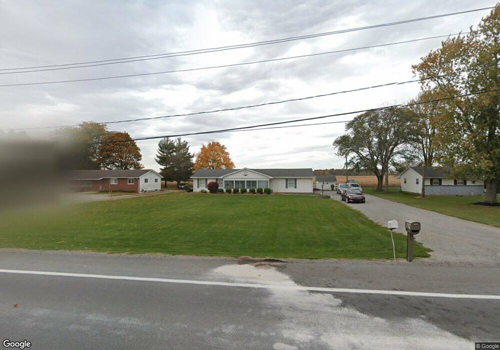
This home is located at 4745 State Route 235, Ada, OH 45810 and is currently estimated at $207,969, approximately $170 per square foot. 4745 State Route 235 is a home located in Hardin County with nearby schools including Ada Elementary School and Ada High School.
Ownership History
Date
Name
Owned For
Owner Type
Purchase Details
Closed on
Aug 4, 2023
Sold by
Price Barbara and Ridge Joyce
Bought by
Balmert Arthur
Current Estimated Value
Home Financials for this Owner
Home Financials are based on the most recent Mortgage that was taken out on this home.
Original Mortgage
$148,000
Outstanding Balance
$144,721
Interest Rate
6.96%
Mortgage Type
New Conventional
Estimated Equity
$63,248
Purchase Details
Closed on
May 15, 1992
Create a Home Valuation Report for This Property
The Home Valuation Report is an in-depth analysis detailing your home's value as well as a comparison with similar homes in the area
Home Values in the Area
Average Home Value in this Area
Purchase History
| Date | Buyer | Sale Price | Title Company |
|---|---|---|---|
| Balmert Arthur | $185,000 | Innovative Title & Escrow | |
| Balmert Arthur | $185,000 | Innovative Title & Escrow | |
| Balmert Arthur | $185,000 | Innovative Title & Escrow | |
| Balmert Arthur | $185,000 | Innovative Title & Escrow | |
| -- | -- | -- | |
| -- | -- | -- |
Source: Public Records
Mortgage History
| Date | Status | Borrower | Loan Amount |
|---|---|---|---|
| Open | Balmert Arthur | $148,000 | |
| Closed | Balmert Arthur | $148,000 |
Source: Public Records
Tax History Compared to Growth
Tax History
| Year | Tax Paid | Tax Assessment Tax Assessment Total Assessment is a certain percentage of the fair market value that is determined by local assessors to be the total taxable value of land and additions on the property. | Land | Improvement |
|---|---|---|---|---|
| 2024 | $1,751 | $46,050 | $7,350 | $38,700 |
| 2023 | $1,751 | $46,050 | $7,350 | $38,700 |
| 2022 | $1,159 | $35,630 | $3,700 | $31,930 |
| 2021 | $1,276 | $35,630 | $3,700 | $31,930 |
| 2020 | $1,293 | $35,630 | $3,700 | $31,930 |
| 2019 | $1,101 | $31,870 | $3,530 | $28,340 |
| 2018 | $1,076 | $31,870 | $3,530 | $28,340 |
| 2017 | $1,049 | $31,870 | $3,530 | $28,340 |
| 2016 | $870 | $28,880 | $3,090 | $25,790 |
| 2015 | $1,200 | $28,880 | $3,090 | $25,790 |
| 2014 | $442 | $28,880 | $3,090 | $25,790 |
| 2013 | $471 | $29,080 | $3,090 | $25,990 |
Source: Public Records
Map
Nearby Homes
- 710 S Main St
- 623 S Gilbert St
- 617 S Gilbert St
- 613 S Gilbert St
- 314 E University Ave
- 301 S Main St
- 308-310 S Simon St
- 4071 Township Road 35
- 2864 Ohio 309
- 211 W Buckeye Ave Unit 211 1/2
- 118 W Buckeye Ave
- 211 S Main St
- 210 N Gilbert St
- 212 N Simon St
- 442 Edwards St
- 444 Edwards St Unit A, B
- 444 Edwards St Unit 2
- 128 W North Ave
- 629 N Main St
- 3931 County Road 80
- 4745 Ohio 235
- 4745 State Route
- 4719 State Route 235
- 4719 Ohio 235
- 4781 State Route 235
- 4697 State Route 235
- 4697 Ohio 235
- 4801 State Route 235 Unit 4817
- 4663 State Route 235
- 4748 State Route 235
- 4845 State Route 235
- 4623 State Route 235
- 4623 State Route 235
- 4624 State Route 235
- 4838 State Route 235
- 4611 State Route
- 4611 State Route 235
- 4887 State Route 235
- 4563 State Route 235