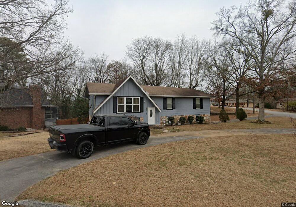
475 King Crest Ln Hixson, TN 37343
Valleybrook NeighborhoodEstimated Value: $315,000 - $367,000
3
Beds
2
Baths
2,225
Sq Ft
$155/Sq Ft
Est. Value
About This Home
This home is located at 475 King Crest Ln, Hixson, TN 37343 and is currently estimated at $345,799, approximately $155 per square foot. 475 King Crest Ln is a home located in Hamilton County with nearby schools including Hixson Elementary School, Hixson Middle School, and Hixson High School.
Ownership History
Date
Name
Owned For
Owner Type
Purchase Details
Closed on
Mar 18, 2016
Sold by
Whitt Amy Kristen and Whitt Mark S
Bought by
Whitt Mark S
Current Estimated Value
Home Financials for this Owner
Home Financials are based on the most recent Mortgage that was taken out on this home.
Original Mortgage
$17,000
Outstanding Balance
$10,432
Interest Rate
3.62%
Mortgage Type
Credit Line Revolving
Estimated Equity
$335,367
Purchase Details
Closed on
Dec 18, 1995
Sold by
Atkins Billy T
Bought by
Kristen Atkins Amy
Purchase Details
Closed on
Sep 22, 1995
Bought by
Atkins Billy T
Create a Home Valuation Report for This Property
The Home Valuation Report is an in-depth analysis detailing your home's value as well as a comparison with similar homes in the area
Home Values in the Area
Average Home Value in this Area
Purchase History
| Date | Buyer | Sale Price | Title Company |
|---|---|---|---|
| Whitt Mark S | -- | Pioneer Title Agency Inc | |
| Kristen Atkins Amy | $76,000 | -- | |
| Atkins Billy T | $75,900 | -- |
Source: Public Records
Mortgage History
| Date | Status | Borrower | Loan Amount |
|---|---|---|---|
| Open | Whitt Mark S | $17,000 |
Source: Public Records
Tax History Compared to Growth
Tax History
| Year | Tax Paid | Tax Assessment Tax Assessment Total Assessment is a certain percentage of the fair market value that is determined by local assessors to be the total taxable value of land and additions on the property. | Land | Improvement |
|---|---|---|---|---|
| 2024 | $1,163 | $51,975 | $0 | $0 |
| 2023 | $1,163 | $51,975 | $0 | $0 |
| 2022 | $1,163 | $51,975 | $0 | $0 |
| 2021 | $1,163 | $51,975 | $0 | $0 |
| 2020 | $986 | $35,675 | $0 | $0 |
| 2019 | $986 | $35,675 | $0 | $0 |
| 2018 | $939 | $35,675 | $0 | $0 |
| 2017 | $986 | $35,675 | $0 | $0 |
| 2016 | $907 | $0 | $0 | $0 |
| 2015 | $1,780 | $32,800 | $0 | $0 |
| 2014 | $1,780 | $0 | $0 | $0 |
Source: Public Records
Map
Nearby Homes
- 5848 Grubb Rd
- 437 English Oaks Dr
- 1225 Dreamcatcher Way
- 808 Fox Chase Ln
- 5713 Dagney Ln
- 790 Wood Grove Cir
- 5741 Lyle Cir
- 753 Wood Grove Cir
- 421 Golden Oaks Dr
- 5967 Winding Ln
- 434 Stoneridge Dr
- 743 Ashley Forest Dr
- 6043 Mill Rd
- 5813 Ragnar Dr
- 5813 Northwoods Dr
- Franklin Plan at Hawthorne Pointe
- Heyward Plan at Hawthorne Pointe
- Livingston Plan at Hawthorne Pointe
- 5925 Winding Ln
- 6562 Esquire Ln
- 477 King Crest Ln
- 439 Kingsridge Dr
- 481 King Crest Ln
- 476 King Crest Ln
- 442 Kingsridge Dr
- 437 Kingsridge Dr
- 440 Kingsridge Dr
- 440 Kingsridge Dr Unit Lot 44
- 444 Kingsridge Dr
- 480 King Crest Ln
- 436 Kingsridge Dr
- 483 King Crest Ln
- 448 Kingsridge Dr
- 451 Kingsridge Dr
- 508 Woodcroft Dr
- 420 Kingsridge Dr
- 422 Kingsridge Dr
- 418 Kingsridge Dr
- 433 Kingsridge Dr
- 450 Kingsridge Dr