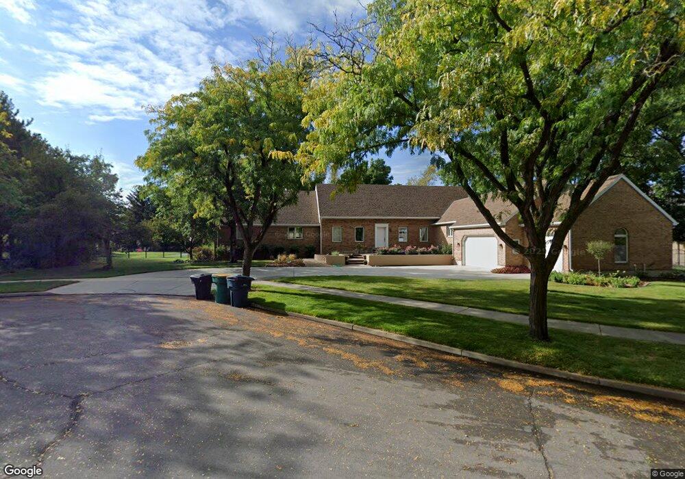
476 E 1320 N Orem, UT 84097
Windsor NeighborhoodEstimated Value: $2,029,891 - $2,648,000
5
Beds
5
Baths
5,666
Sq Ft
$413/Sq Ft
Est. Value
About This Home
This home is located at 476 E 1320 N, Orem, UT 84097 and is currently estimated at $2,338,946, approximately $412 per square foot. 476 E 1320 N is a home located in Utah County with nearby schools including Orchard Elementary School, Canyon View Junior High School, and Timpanogos High School.
Ownership History
Date
Name
Owned For
Owner Type
Purchase Details
Closed on
Mar 22, 2005
Sold by
Western National Trust Co
Bought by
Mallory Thomas J and Mallory Pamela B
Current Estimated Value
Home Financials for this Owner
Home Financials are based on the most recent Mortgage that was taken out on this home.
Original Mortgage
$100,000
Outstanding Balance
$50,999
Interest Rate
5.7%
Mortgage Type
Credit Line Revolving
Estimated Equity
$2,287,947
Purchase Details
Closed on
Apr 24, 2001
Sold by
First Security Bank Na
Bought by
Zions First National Bank
Create a Home Valuation Report for This Property
The Home Valuation Report is an in-depth analysis detailing your home's value as well as a comparison with similar homes in the area
Home Values in the Area
Average Home Value in this Area
Purchase History
| Date | Buyer | Sale Price | Title Company |
|---|---|---|---|
| Mallory Thomas J | -- | First American Title | |
| Zions First National Bank | -- | First Security Bank | |
| First Security Bank Na | -- | -- |
Source: Public Records
Mortgage History
| Date | Status | Borrower | Loan Amount |
|---|---|---|---|
| Open | Mallory Thomas J | $100,000 |
Source: Public Records
Tax History
| Year | Tax Paid | Tax Assessment Tax Assessment Total Assessment is a certain percentage of the fair market value that is determined by local assessors to be the total taxable value of land and additions on the property. | Land | Improvement |
|---|---|---|---|---|
| 2025 | $7,593 | $1,054,915 | -- | -- |
| 2024 | $7,593 | $928,410 | $0 | $0 |
| 2023 | $6,817 | $895,960 | $0 | $0 |
| 2022 | $7,024 | $1,616,500 | $605,600 | $1,010,900 |
| 2021 | $6,950 | $1,335,600 | $545,800 | $789,800 |
| 2020 | $6,548 | $1,237,000 | $455,000 | $782,000 |
| 2019 | $5,675 | $1,114,400 | $455,000 | $659,400 |
| 2018 | $5,939 | $1,114,400 | $455,000 | $659,400 |
| 2017 | $6,098 | $615,170 | $0 | $0 |
| 2016 | $6,282 | $584,370 | $0 | $0 |
| 2015 | $6,330 | $556,870 | $0 | $0 |
| 2014 | $6,202 | $543,120 | $0 | $0 |
Source: Public Records
Map
Nearby Homes
- 372 E 1165 N
- 1371 N 330 E Unit 8
- 363 E 1395 N Unit 22
- 1480 N 430 E
- 723 E 1450 N Unit 25
- 710 E 1280 N
- 713 E 1450 N Unit 23
- 733 E 1450 N Unit 5
- 713 E 1500 St N Unit 19
- 976 N 560 E
- 1324 N 750 E Unit 3
- 747 E 1500 N Unit 13
- 1356 N 750 E Unit 11
- 1366 N 750 E
- 540 E Quail Rd
- 1636 N 160 E
- 1638 N 160 E
- 1643 N Mountain Oaks Dr
- 917 N Garden Dr
- 362 E 800 N Unit 1
- 1261 Gillman Cir
- 431 E 1280 N
- 488 E 1320 N
- 1261 N 475 E
- 1262 Gillman Cir
- 1266 N 430 E Unit 5
- 1249 Gillman Cir
- 464 E 1320 N
- 1252 N 430 E
- 425 E 1280 N Unit 3
- 481 E 1320 N
- 1250 Gillman Cir
- 1265 N 430 E Unit 10
- 1235 Gillman Cir
- 1234 Gillman Cir
- 1234 N 430 E
- 415 E 1280 N
- 1251 N 430 E Unit 9
- 410 E 1280 N
- 444 E 1325 N
Your Personal Tour Guide
Ask me questions while you tour the home.