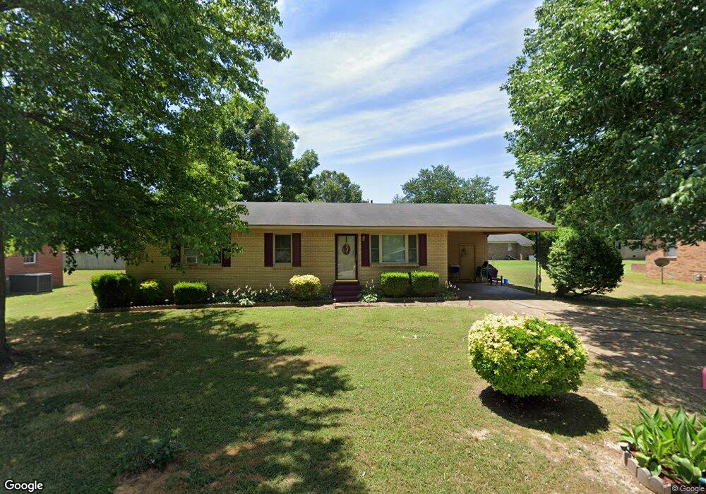
477 Addie B St Brownsville, TN 38012
Estimated Value: $150,000 - $181,000
3
Beds
2
Baths
1,540
Sq Ft
$104/Sq Ft
Est. Value
About This Home
This home is located at 477 Addie B St, Brownsville, TN 38012 and is currently estimated at $160,434, approximately $104 per square foot. 477 Addie B St is a home located in Haywood County with nearby schools including Anderson Early Childhood Center, Haywood Elementary School, and East Side Elementary School.
Ownership History
Date
Name
Owned For
Owner Type
Purchase Details
Closed on
Sep 9, 2024
Sold by
Palmer Darestine and Clark Darestine
Bought by
Clark Darestine and Palmer Darestine
Current Estimated Value
Purchase Details
Closed on
Mar 10, 1992
Bought by
Palmer Darestine
Purchase Details
Closed on
May 13, 1991
Bought by
S A U
Purchase Details
Closed on
Jan 1, 1985
Bought by
Shaw Bennie C
Purchase Details
Closed on
Jan 1, 1984
Purchase Details
Closed on
Aug 26, 1977
Create a Home Valuation Report for This Property
The Home Valuation Report is an in-depth analysis detailing your home's value as well as a comparison with similar homes in the area
Home Values in the Area
Average Home Value in this Area
Purchase History
| Date | Buyer | Sale Price | Title Company |
|---|---|---|---|
| Clark Darestine | -- | None Listed On Document | |
| Palmer Darestine | $35,500 | -- | |
| S A U | $27,500 | -- | |
| Shaw Bennie C | $32,500 | -- | |
| -- | $22,500 | -- | |
| -- | -- | -- |
Source: Public Records
Tax History Compared to Growth
Tax History
| Year | Tax Paid | Tax Assessment Tax Assessment Total Assessment is a certain percentage of the fair market value that is determined by local assessors to be the total taxable value of land and additions on the property. | Land | Improvement |
|---|---|---|---|---|
| 2024 | -- | $35,650 | $1,225 | $34,425 |
| 2023 | $812 | $17,200 | $1,125 | $16,075 |
| 2022 | $812 | $17,200 | $1,125 | $16,075 |
| 2021 | $812 | $17,200 | $1,125 | $16,075 |
| 2020 | $965 | $17,200 | $1,125 | $16,075 |
| 2019 | $965 | $20,425 | $1,125 | $19,300 |
| 2018 | $754 | $16,125 | $1,125 | $15,000 |
| 2017 | $754 | $16,125 | $1,125 | $15,000 |
| 2016 | $717 | $16,125 | $1,125 | $15,000 |
| 2015 | $718 | $16,125 | $1,125 | $15,000 |
| 2014 | $838 | $19,975 | $1,125 | $18,850 |
Source: Public Records
Map
Nearby Homes
- 521 Lark St
- . Fairground Rd
- 119 Jelk St
- 1237 Hess St
- 1020 N Lafayette Ave
- 1014 N Monroe Ave
- 1005 N Lafayette Ave
- 930 N Monroe Ave
- 808 Hart Dr
- 814 N Washington Ave
- 620 N Lafayette Ave
- 515 N Lafayette Ave
- 00 Jim Miller Rd
- 857 W Thomas St
- 322 N Lafayette Ave
- 1434 Key Corner St
- 00 Stonebrook (Lot 27) Place
- 313 W College St
- 114 College Hill Village
- 522 W College St