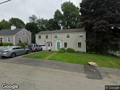
48 Abigail Adams Cir North Weymouth, MA 02191
Estimated Value: $622,903 - $669,000
4
Beds
2
Baths
1,530
Sq Ft
$424/Sq Ft
Est. Value
About This Home
This home is located at 48 Abigail Adams Cir, North Weymouth, MA 02191 and is currently estimated at $649,476, approximately $424 per square foot. 48 Abigail Adams Cir is a home located in Norfolk County with nearby schools including Abigail Adams Middle School, Wessagusset Elementary School, and Weymouth Middle School Chapman.
Ownership History
Date
Name
Owned For
Owner Type
Purchase Details
Closed on
Jan 24, 1994
Sold by
Woods William L and Woods Doris C
Bought by
Jeanjaquet Robert L and Jeanjaquet Elizabeth
Current Estimated Value
Home Financials for this Owner
Home Financials are based on the most recent Mortgage that was taken out on this home.
Original Mortgage
$115,200
Interest Rate
7.08%
Mortgage Type
Purchase Money Mortgage
Create a Home Valuation Report for This Property
The Home Valuation Report is an in-depth analysis detailing your home's value as well as a comparison with similar homes in the area
Home Values in the Area
Average Home Value in this Area
Purchase History
| Date | Buyer | Sale Price | Title Company |
|---|---|---|---|
| Jeanjaquet Robert L | $130,000 | -- |
Source: Public Records
Mortgage History
| Date | Status | Borrower | Loan Amount |
|---|---|---|---|
| Open | Jeanjaquet Robert L | $106,000 | |
| Closed | Jeanjaquet Robert L | $115,200 |
Source: Public Records
Tax History Compared to Growth
Tax History
| Year | Tax Paid | Tax Assessment Tax Assessment Total Assessment is a certain percentage of the fair market value that is determined by local assessors to be the total taxable value of land and additions on the property. | Land | Improvement |
|---|---|---|---|---|
| 2025 | $5,291 | $523,900 | $239,900 | $284,000 |
| 2024 | $5,126 | $499,100 | $228,500 | $270,600 |
| 2023 | $4,683 | $448,100 | $211,600 | $236,500 |
| 2022 | $4,584 | $400,000 | $195,900 | $204,100 |
| 2021 | $4,485 | $382,000 | $195,900 | $186,100 |
| 2020 | $4,319 | $362,300 | $195,900 | $166,400 |
| 2019 | $4,248 | $350,500 | $188,400 | $162,100 |
| 2018 | $4,185 | $334,800 | $179,400 | $155,400 |
| 2017 | $4,086 | $319,000 | $170,900 | $148,100 |
| 2016 | $3,987 | $311,500 | $164,300 | $147,200 |
| 2015 | $3,848 | $298,300 | $164,300 | $134,000 |
| 2014 | $3,600 | $270,700 | $146,500 | $124,200 |
Source: Public Records
Map
Nearby Homes
- 25 Church St Unit 2
- 10 Richards Rd
- 124 Mount Vernon Rd W
- 70 Biscayne Ave
- 188 Idlewell Blvd
- 30 Katherine St
- 323 Green St
- 18 Genevieve Rd
- 59 Katherine St
- 146 Rindge St
- 26 Presidents Rd
- 30 Lillian Rd
- 207 Evans St
- 43 Coolidge Ave
- 208 Green St
- 14 Crescent Rd
- 45 Doris Dr
- 90 Sea St Unit 219
- 118 Academy Ave
- 9 Aspinwall Ave
- 48 Abigail Adams Cir
- 44 Abigail Adams Cir
- 54 Abigail Adams Cir
- 45 Abigail Adams Cir
- 36 Abigail Adams Cir
- 60 Abigail Adams Cir
- 55 Abigail Adams Cir
- 39 Abigail Adams Cir
- 61 Abigail Adams Cir
- 66 Abigail Adams Cir
- 45 Farren Rd
- 10 John Quincy Ln
- 27 Church St Unit 14
- 27 Church St Unit 13
- 27 Church St Unit 12
- 27 Church St Unit 11
- 20 John Quincy Ln
- 26 John Quincy Ln
- 70 Abigail Adams Cir
- 71 Abigail Adams Cir