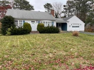
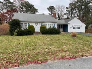
48 Captain Dore Rd South Yarmouth, MA 02664
South Yarmouth NeighborhoodEstimated payment $3,033/month
Highlights
- No HOA
- 1 Car Attached Garage
- Hot Water Heating System
- Porch
- Property is near shops
- Level Lot
About This Home
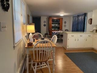
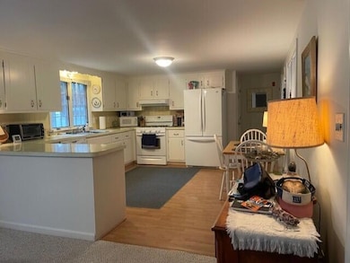
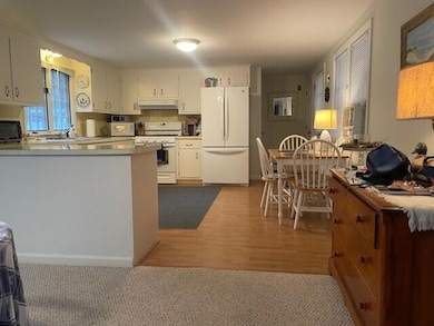
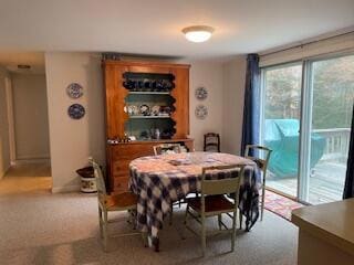
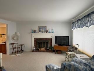
Desirable Captain's Village, check out this great value for this approximately 1148 sq, ft, 2 bedroom, 1 bath Ranch! The home is in good condition and features a roomy kitchen open to dining area with slider to rear deck with private back yard. The home also features a cozy fire-placed living room, 1 car garage, large open full basement, gas hot water and gas forced water heat and more. conveniently located in a residential neighborhood close to schools, shopping, dining, golf and some of Yarmouth's finest beaches! Take advantage of this great opportunity now.
Home Details
Home Type
- Single Family
Est. Annual Taxes
- $3,230
Year Built
- Built in 1972
Lot Details
- 0.28 Acre Lot
- Level Lot
Parking
- 1 Car Attached Garage
- Open Parking
Home Design
- Poured Concrete
- Pitched Roof
- Asphalt Roof
- Shingle Siding
- Clapboard
Interior Spaces
- 1,149 Sq Ft Home
- 1-Story Property
- Wood Burning Fireplace
Kitchen
- Gas Range
- Dishwasher
Flooring
- Carpet
- Vinyl
Bedrooms and Bathrooms
- 2 Bedrooms
- 1 Full Bathroom
Basement
- Basement Fills Entire Space Under The House
- Interior Basement Entry
Outdoor Features
- Porch
Location
- Property is near shops
- Property is near a golf course
Utilities
- No Cooling
- Hot Water Heating System
- Gas Water Heater
- Private Sewer
Community Details
- No Home Owners Association
- Captain's Village Subdivision
- Near Conservation Area
Listing and Financial Details
- Assessor Parcel Number YARM M:0067 B:00183 L:0000
Map
Home Values in the Area
Average Home Value in this Area
Tax History
| Year | Tax Paid | Tax Assessment Tax Assessment Total Assessment is a certain percentage of the fair market value that is determined by local assessors to be the total taxable value of land and additions on the property. | Land | Improvement |
|---|---|---|---|---|
| 2025 | $3,476 | $490,900 | $179,300 | $311,600 |
| 2024 | $3,230 | $437,700 | $151,600 | $286,100 |
| 2023 | $3,122 | $385,000 | $131,200 | $253,800 |
| 2022 | $3,190 | $347,500 | $119,300 | $228,200 |
| 2021 | $2,985 | $312,200 | $119,300 | $192,900 |
| 2020 | $2,910 | $291,000 | $119,300 | $171,700 |
| 2019 | $2,680 | $265,300 | $119,300 | $146,000 |
| 2018 | $2,548 | $247,600 | $101,600 | $146,000 |
| 2017 | $2,437 | $243,200 | $97,200 | $146,000 |
| 2016 | $2,338 | $234,300 | $88,300 | $146,000 |
| 2015 | $2,138 | $212,900 | $88,300 | $124,600 |
Property History
| Date | Event | Price | List to Sale | Price per Sq Ft |
|---|---|---|---|---|
| 11/21/2025 11/21/25 | For Sale | $524,900 | -- | $457 / Sq Ft |
Purchase History
| Date | Type | Sale Price | Title Company |
|---|---|---|---|
| Deed | $284,900 | -- | |
| Deed | $131,000 | -- | |
| Deed | $103,500 | -- |
Mortgage History
| Date | Status | Loan Amount | Loan Type |
|---|---|---|---|
| Previous Owner | $60,000 | Purchase Money Mortgage |
Source: Cape Cod & Islands Association of REALTORS®
MLS Number: 22505705
APN: YARM-000067-000183
Disclaimer: Certain information contained herein is derived from information provided by parties other than Homes.com. All information provided is deemed reliable, but is not guaranteed to be accurate and should be independently verified.
![]() All data relating to real estate for sale on this page comes from the Broker Reciprocity (BR) of the Cape Cod & Islands Multiple Listing Service, Inc. Detailed information about real estate listings held by brokerage firms other than CC&I Assoc. of REALTORS®, Inc. includes the name of the listing company. Neither the listing company nor CC&I Assoc. of REALTORS®, Inc. shall be responsible for any typographical errors, misinformation, misprints and shall be held totally harmless. The Broker providing this data believes it to be correct, but advises interested parties to confirm any item before relying on it in a purchase decision. All properties are subject to prior sale, changes, or withdrawal. Copyright 2025 © Cape Cod & Islands Multiple Listing Service, Inc. All rights reserved.
All data relating to real estate for sale on this page comes from the Broker Reciprocity (BR) of the Cape Cod & Islands Multiple Listing Service, Inc. Detailed information about real estate listings held by brokerage firms other than CC&I Assoc. of REALTORS®, Inc. includes the name of the listing company. Neither the listing company nor CC&I Assoc. of REALTORS®, Inc. shall be responsible for any typographical errors, misinformation, misprints and shall be held totally harmless. The Broker providing this data believes it to be correct, but advises interested parties to confirm any item before relying on it in a purchase decision. All properties are subject to prior sale, changes, or withdrawal. Copyright 2025 © Cape Cod & Islands Multiple Listing Service, Inc. All rights reserved.
- 12 Town Hall Ave
- 45 Bernard St
- 6 Lauries Ln
- 28 Swan Lake Rd
- 70 Poinsettia Dr
- 51 Ocean Ave Unit 103
- 166 Seaview Ave Unit 2a
- 483 Route 28
- 80 Mattakese Rd Unit 7
- 40 Bradford Rd
- 7 Columbus Ave
- 90 Wendward Way Unit 90
- 26 Lone Tree Rd Unit A
- 25 Embassy St
- 25 Embassy Ln
- 173 Captain Chase Rd Unit A
- 173 Captain Chase Rd Unit B
- 35 Arlington St
- 13 Railway Bluff Unit 2nd floor
- 60 Pleasant St Unit 3B
