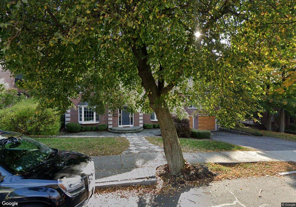
48 Clements Rd Newton, MA 02458
Newton Centre NeighborhoodEstimated Value: $3,141,847 - $3,646,000
5
Beds
6
Baths
4,760
Sq Ft
$720/Sq Ft
Est. Value
About This Home
This home is located at 48 Clements Rd, Newton, MA 02458 and is currently estimated at $3,427,462, approximately $720 per square foot. 48 Clements Rd is a home located in Middlesex County with nearby schools including Ward Elementary School, Bigelow Middle School, and Newton North High School.
Ownership History
Date
Name
Owned For
Owner Type
Purchase Details
Closed on
May 31, 2007
Sold by
Ashwood Homes Inc
Bought by
Chang Bernard S and Holt Amanda
Current Estimated Value
Home Financials for this Owner
Home Financials are based on the most recent Mortgage that was taken out on this home.
Original Mortgage
$1,340,000
Outstanding Balance
$822,157
Interest Rate
6.24%
Mortgage Type
Purchase Money Mortgage
Estimated Equity
$2,605,305
Purchase Details
Closed on
Apr 28, 2006
Sold by
Clements Road Rt
Bought by
Ashwood Homes Inc
Create a Home Valuation Report for This Property
The Home Valuation Report is an in-depth analysis detailing your home's value as well as a comparison with similar homes in the area
Home Values in the Area
Average Home Value in this Area
Purchase History
| Date | Buyer | Sale Price | Title Company |
|---|---|---|---|
| Chang Bernard S | $1,675,000 | -- | |
| Ashwood Homes Inc | $1,812,477 | -- |
Source: Public Records
Mortgage History
| Date | Status | Borrower | Loan Amount |
|---|---|---|---|
| Open | Chang Bernard S | $1,340,000 |
Source: Public Records
Tax History
| Year | Tax Paid | Tax Assessment Tax Assessment Total Assessment is a certain percentage of the fair market value that is determined by local assessors to be the total taxable value of land and additions on the property. | Land | Improvement |
|---|---|---|---|---|
| 2025 | $30,735 | $3,136,200 | $1,377,200 | $1,759,000 |
| 2024 | $29,718 | $3,044,900 | $1,337,100 | $1,707,800 |
| 2023 | $28,611 | $2,810,500 | $1,026,800 | $1,783,700 |
| 2022 | $27,376 | $2,602,300 | $950,700 | $1,651,600 |
| 2021 | $26,202 | $2,435,100 | $896,900 | $1,538,200 |
| 2020 | $25,422 | $2,435,100 | $896,900 | $1,538,200 |
| 2019 | $24,706 | $2,364,200 | $870,800 | $1,493,400 |
| 2018 | $23,755 | $2,195,500 | $790,000 | $1,405,500 |
| 2017 | $23,032 | $2,071,200 | $745,300 | $1,325,900 |
| 2016 | $22,028 | $1,935,700 | $696,500 | $1,239,200 |
| 2015 | $21,004 | $1,809,100 | $650,900 | $1,158,200 |
Source: Public Records
Map
Nearby Homes
- 21 Francis St Unit 21A
- 19 Chestnut Terrace
- 34 Chestnut Terrace
- 33 George St Unit 33
- 35 George St Unit 35
- 37 George St Unit 37
- 53 Marshall St
- 20 Rice St
- 642 Centre St
- 106 Farlow Rd
- 8 Bennington St
- 269 Franklin St
- 3 Cedar St
- 129 Withington Rd Unit 129
- 158 E Side Pkwy
- 123 Park St
- 39 Commonwealth Ave Unit 31
- 116 Lake Shore Rd Unit 4
- 27-29 Commonwealth Ave Unit 9
- 34 Morton Rd
Your Personal Tour Guide
Ask me questions while you tour the home.