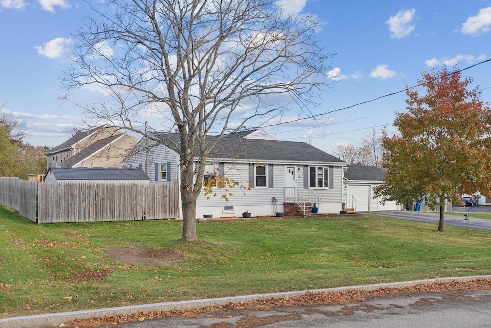
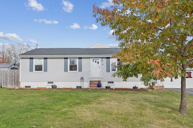
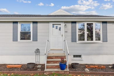
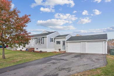
48 Nasson Ave Westbrook, ME 04092
Estimated payment $3,017/month
Highlights
- Ranch Style House
- Corner Lot
- 2 Car Attached Garage
- Wood Flooring
- No HOA
- Baseboard Heating
About This Home
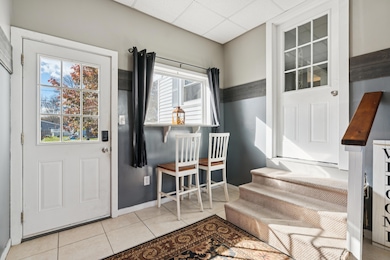
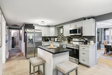
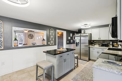
Updated ranch-style home perfectly set on a spacious .25-acre corner lot. Step through the finished entryway and you'll notice how warm and inviting this home feels. It offers three bedrooms, a partially finished basement with a cozy family room, and an attached two-car garage that adds both convenience and functionality. The kitchen is a real standout, featuring stainless steel appliances, plenty of cabinet space, and a modern design that makes cooking and entertaining enjoyable. The layout flows easily from the kitchen to the dining and living areas, creating a bright space perfect for everyday living or hosting. This home combines classic ranch charm with modern updates and is truly move-in ready. With a backyard that's ideal for entertaining friends and family. Whether you're grilling out, relaxing on the patio, or enjoying a quiet evening under the stars. Conveniently located near schools, parks, and shopping, it's the perfect place to settle in and make your own.
Listing Agent
Alicia Frechette Ramsey Pulkkinen
A Team Realty Brokerage Email: info@ateammaine.com Listed on: 11/11/2025
Property Details
Home Type
- Modular Prefabricated Home
Est. Annual Taxes
- $4,620
Year Built
- Built in 1973
Lot Details
- 0.25 Acre Lot
- Corner Lot
- Level Lot
- Open Lot
Parking
- 2 Car Attached Garage
- Garage Door Opener
Home Design
- Single Family Detached Home
- Ranch Style House
- Modular Prefabricated Home
- Shingle Roof
- Vinyl Siding
Kitchen
- Electric Range
- Microwave
- Dishwasher
Flooring
- Wood
- Carpet
- Vinyl
Bedrooms and Bathrooms
- 3 Bedrooms
- 1 Full Bathroom
Laundry
- Dryer
- Washer
Finished Basement
- Basement Fills Entire Space Under The House
- Partial Basement
- Interior Basement Entry
- Sump Pump
Utilities
- No Cooling
- Heat Pump System
- Baseboard Heating
Community Details
- No Home Owners Association
Listing and Financial Details
- Tax Lot 045
- Assessor Parcel Number WSBR-000043-000000-000045C
Map
Home Values in the Area
Average Home Value in this Area
Tax History
| Year | Tax Paid | Tax Assessment Tax Assessment Total Assessment is a certain percentage of the fair market value that is determined by local assessors to be the total taxable value of land and additions on the property. | Land | Improvement |
|---|---|---|---|---|
| 2023 | $4,620 | $277,000 | $84,600 | $192,400 |
| 2022 | $4,190 | $231,500 | $70,600 | $160,900 |
| 2021 | $4,063 | $227,900 | $70,600 | $157,300 |
| 2020 | $4,070 | $227,900 | $70,600 | $157,300 |
| 2019 | $4,070 | $227,900 | $70,600 | $157,300 |
| 2018 | $3,886 | $194,800 | $61,300 | $133,500 |
| 2017 | $3,678 | $194,800 | $61,300 | $133,500 |
| 2016 | $3,584 | $194,800 | $61,300 | $133,500 |
| 2015 | $3,499 | $194,800 | $61,300 | $133,500 |
| 2014 | $3,351 | $194,800 | $61,300 | $133,500 |
| 2013 | $3,351 | $194,800 | $61,300 | $133,500 |
Property History
| Date | Event | Price | List to Sale | Price per Sq Ft |
|---|---|---|---|---|
| 11/17/2025 11/17/25 | Price Changed | $499,900 | -2.0% | $299 / Sq Ft |
| 11/11/2025 11/11/25 | For Sale | $510,000 | -- | $305 / Sq Ft |
Purchase History
| Date | Type | Sale Price | Title Company |
|---|---|---|---|
| Interfamily Deed Transfer | -- | -- | |
| Warranty Deed | -- | -- |
Mortgage History
| Date | Status | Loan Amount | Loan Type |
|---|---|---|---|
| Open | $10,000 | Purchase Money Mortgage | |
| Open | $202,500 | Purchase Money Mortgage |
Source: Maine Listings
MLS Number: 1643227
APN: WSBR-000043-000000-000045C
Disclaimer: Certain information contained herein is derived from information provided by parties other than Homes.com. All information provided is deemed reliable, but is not guaranteed to be accurate and should be independently verified.
![]() Listing data is derived in whole or in part from Maine Real Estate Information System, Inc. (d/b/a Maine Listings) and is for consumers' personal, noncommercial use only. Dimensions are approximate and not guaranteed. All data should be independently verified.
Listing data is derived in whole or in part from Maine Real Estate Information System, Inc. (d/b/a Maine Listings) and is for consumers' personal, noncommercial use only. Dimensions are approximate and not guaranteed. All data should be independently verified.
© 2025 Maine Real Estate Information System, Inc. All Rights Reserved. Equal Housing Opportunity.
Homes.com, LLC, 17600 Laguna Canyon Rd Irvine, CA 92618 (888)-952-6393
![]()
- 42 Lowell St
- 154 Myrtle St
- 45 Emery St
- 110 Myrtle St
- 3 Collins Place Unit 5
- 159 Lincoln St Unit 15
- 27 Fawn Woods Way Unit 27
- 17 Graham Rd Unit 3
- 620 Cumberland St
- 18 Cole St
- 10 Nicklaus Ln
- 5 Apex Dr Unit 1
- 7 Apex Dr Unit 2
- 21 Clover Ln Unit 201
- 21 Clover Ln Unit 103
- 21 Clover Ln Unit 402
- 21 Clover Ln Unit 406
- 21 Clover Ln Unit 309
- 21 Clover Ln Unit 109
- 21 Clover Ln Unit 306
- 1 Ari Dr
- 762 Main St Unit 1
- 2 New Gorham Rd Unit 2
- 39 W Pleasant St
- 20-24 Autumn Woods Dr
- 16 Blue Spruce Farm Rd
- 6-14 Island View Dr
- 6-12 Jacqueline Way
- 723 Riverside St
- 24 Rowe Ave Unit 1
- 84 Johnson Rd Unit Main
- 64 County Rd
- 1060 Forest Ave Unit 2
- 147 Pleasant Ave
- 1619 Washington Ave
- 10 White Birch Ln
- 34 Pleasant Ave Unit 34
- 240 Harvard St
- 73 State St
- 46 Saunders St Unit FLOOR 1
