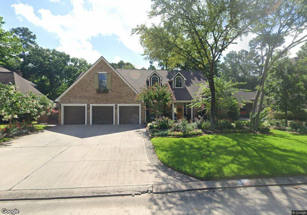
48 Rolling Links Ct Spring, TX 77380
Grogan's Mill NeighborhoodEstimated Value: $935,000 - $1,150,000
Studio
4
Baths
3,929
Sq Ft
$259/Sq Ft
Est. Value
About This Home
This home is located at 48 Rolling Links Ct, Spring, TX 77380 and is currently estimated at $1,015,740, approximately $258 per square foot. 48 Rolling Links Ct is a home located in Montgomery County with nearby schools including Lamar Elementary School, W.D Wilkerson Intermediate School, and Knox J High School.
Ownership History
Date
Name
Owned For
Owner Type
Purchase Details
Closed on
Mar 30, 2007
Sold by
Rice Daniel V and Rice Regina M
Bought by
Tompkins David Lynn and Tompkins Catherine
Current Estimated Value
Home Financials for this Owner
Home Financials are based on the most recent Mortgage that was taken out on this home.
Original Mortgage
$265,000
Outstanding Balance
$161,544
Interest Rate
6.3%
Mortgage Type
Purchase Money Mortgage
Estimated Equity
$854,196
Purchase Details
Closed on
May 24, 2006
Sold by
Kirby Robert G and Kirby Margaret S
Bought by
Rice Daniel and Rice Regina M
Home Financials for this Owner
Home Financials are based on the most recent Mortgage that was taken out on this home.
Original Mortgage
$37,500
Interest Rate
6.56%
Mortgage Type
Stand Alone Second
Purchase Details
Closed on
Sep 1, 1982
Bought by
Tompkins David Lynn and Tompkins Catherine
Create a Home Valuation Report for This Property
The Home Valuation Report is an in-depth analysis detailing your home's value as well as a comparison with similar homes in the area
Home Values in the Area
Average Home Value in this Area
Purchase History
| Date | Buyer | Sale Price | Title Company |
|---|---|---|---|
| Tompkins David Lynn | -- | South Land Title Company Of | |
| Rice Daniel | -- | Old Republic Title | |
| Tompkins David Lynn | -- | -- |
Source: Public Records
Mortgage History
| Date | Status | Borrower | Loan Amount |
|---|---|---|---|
| Open | Tompkins David Lynn | $265,000 | |
| Previous Owner | Rice Daniel | $37,500 | |
| Previous Owner | Rice Daniel | $300,000 |
Source: Public Records
Tax History
| Year | Tax Paid | Tax Assessment Tax Assessment Total Assessment is a certain percentage of the fair market value that is determined by local assessors to be the total taxable value of land and additions on the property. | Land | Improvement |
|---|---|---|---|---|
| 2025 | $6,821 | $807,131 | -- | -- |
| 2024 | $6,849 | $733,755 | -- | -- |
| 2023 | $6,849 | $667,050 | $160,000 | $571,900 |
| 2022 | $11,395 | $606,410 | $160,000 | $571,940 |
| 2021 | $11,069 | $551,280 | $33,870 | $599,250 |
| 2020 | $10,540 | $501,160 | $33,870 | $467,290 |
| 2019 | $11,209 | $514,950 | $33,870 | $481,080 |
| 2018 | $9,792 | $515,070 | $33,870 | $481,200 |
| 2017 | $10,817 | $490,330 | $33,870 | $693,660 |
| 2016 | $9,833 | $445,750 | $33,870 | $730,470 |
| 2015 | $8,063 | $405,230 | $33,870 | $730,470 |
| 2014 | $8,063 | $368,390 | $33,870 | $334,520 |
Source: Public Records
Map
Nearby Homes
- 46 Rolling Links Ct
- 49 Rolling Links Ct
- 67 Woodhaven Wood Dr
- 2 Rolling Mill Ln
- 13 Woodhaven Wood Dr
- 3306 Old Ironwood Dr
- 26 Wishbonebush Rd
- 17 Brookflower Rd
- 1 Green Blade Ln
- 2 Kittiwake Ct
- 26522 Hillside Dr
- 426 Nursery Rd
- 2 Chatterbird Ln
- 424 Nursery Rd
- 186 Spring Pines Dr
- 504 Nursery Rd Unit 2210
- 25657 Interstate 45
- 203 Ridgewood Dr
- 16 Crinkleroot Ct
- 222 Ridgewood Dr
- 50 Rolling Links Ct
- 45 Rolling Links Ct
- 54 Rolling Links Ct
- 712 S Millbend Dr
- 2 Brushwood Ct
- 58 Rolling Links Ct
- 41 Rolling Links Ct
- 53 Rolling Links Ct
- 6 Brushwood Ct
- 30 Rolling Links Ct
- 79 Woodhaven Wood Dr
- 800 S Millbend Dr
- 31 Rolling Links Ct
- 37 Rolling Links Ct
- 57 Rolling Links Ct
- 704 S Millbend Dr
- 10 Brushwood Ct
- 83 Woodhaven Wood Dr
- 61 Rolling Links Ct
- 33 Rolling Links Ct
Your Personal Tour Guide
Ask me questions while you tour the home.