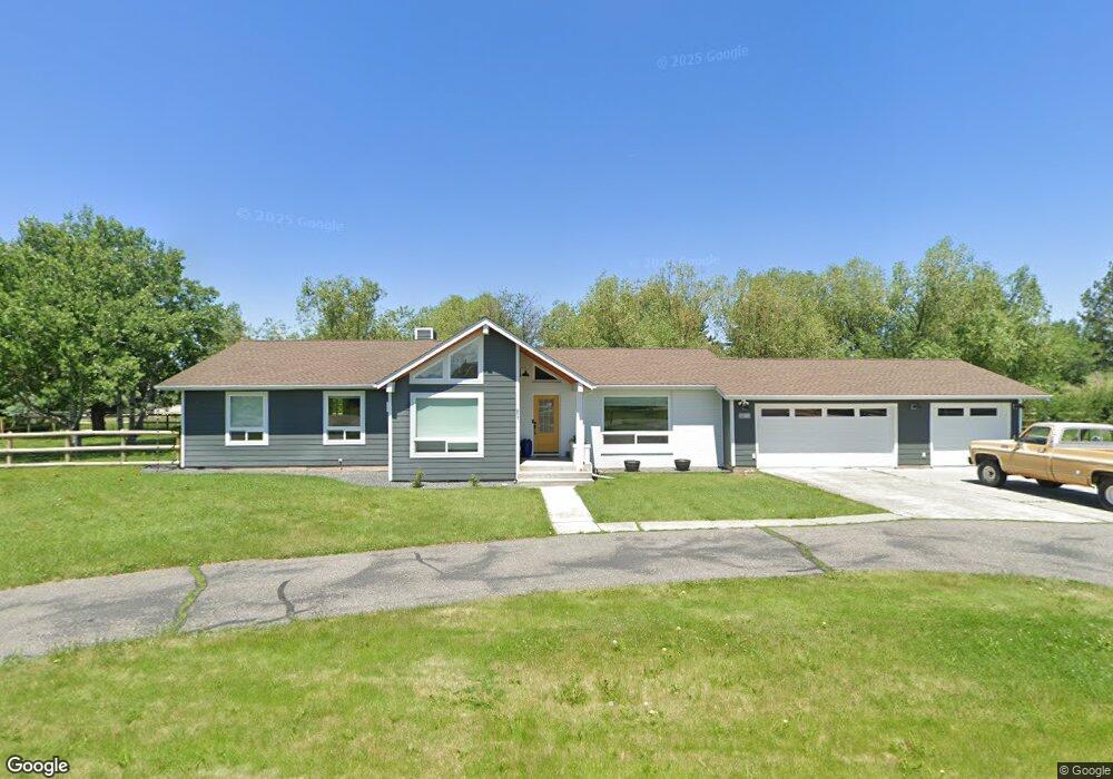
48 Sundance Trail Bozeman, MT 59718
Four Corners NeighborhoodEstimated Value: $698,746 - $854,000
3
Beds
2
Baths
1,951
Sq Ft
$399/Sq Ft
Est. Value
About This Home
This home is located at 48 Sundance Trail, Bozeman, MT 59718 and is currently estimated at $777,687, approximately $398 per square foot. 48 Sundance Trail is a home located in Gallatin County with nearby schools including Monforton Primary School, Monforton Elementary School, and Monforton Junior High School.
Ownership History
Date
Name
Owned For
Owner Type
Purchase Details
Closed on
Jun 27, 2019
Sold by
Regli Reba M and Kaiser Donna Coleen
Bought by
Gregg Logan J and Gregg Randi L
Current Estimated Value
Home Financials for this Owner
Home Financials are based on the most recent Mortgage that was taken out on this home.
Original Mortgage
$350,000
Outstanding Balance
$299,518
Interest Rate
2.75%
Mortgage Type
Purchase Money Mortgage
Estimated Equity
$478,169
Purchase Details
Closed on
Oct 14, 2009
Sold by
Regli Donald and Regli Reba
Bought by
Regli Donald I and Regli Reba M
Create a Home Valuation Report for This Property
The Home Valuation Report is an in-depth analysis detailing your home's value as well as a comparison with similar homes in the area
Home Values in the Area
Average Home Value in this Area
Purchase History
| Date | Buyer | Sale Price | Title Company |
|---|---|---|---|
| Gregg Logan J | -- | Security Title Co | |
| Regli Donald I | -- | None Available |
Source: Public Records
Mortgage History
| Date | Status | Borrower | Loan Amount |
|---|---|---|---|
| Open | Gregg Logan J | $350,000 |
Source: Public Records
Tax History
| Year | Tax Paid | Tax Assessment Tax Assessment Total Assessment is a certain percentage of the fair market value that is determined by local assessors to be the total taxable value of land and additions on the property. | Land | Improvement |
|---|---|---|---|---|
| 2025 | $2,577 | $695,700 | $0 | $0 |
| 2024 | $3,887 | $729,600 | $0 | $0 |
| 2023 | $4,346 | $729,600 | $0 | $0 |
| 2022 | $3,147 | $459,200 | $0 | $0 |
| 2021 | $3,532 | $459,200 | $0 | $0 |
| 2020 | $3,546 | $404,000 | $0 | $0 |
| 2019 | $3,449 | $404,600 | $0 | $0 |
| 2018 | $2,907 | $308,900 | $0 | $0 |
| 2017 | $2,544 | $308,900 | $0 | $0 |
| 2016 | $2,389 | $256,200 | $0 | $0 |
| 2015 | $2,289 | $256,200 | $0 | $0 |
| 2014 | $2,662 | $187,249 | $0 | $0 |
Source: Public Records
Map
Nearby Homes
- 51 Schutz Ln
- TBD Dovetail Ln
- 31 Lady Bug Ln
- 3 Mallard Ln
- 1391 Cobb Hill Rd
- Lot 1 Bridge District
- 18 Caboose Ct Unit B
- 34 Caboose Ct Unit C
- 223 New Ventures Dr Unit E
- 247 New Ventures Dr Unit B
- 13 Boxcar Ln
- 254 Pattee Trail
- 26 Locomotive Loop
- 17 Blazer Trail
- 884 Quail Run Rd Unit 884A
- 56 Thatch Wood Ln
- 93 Cedar Shade Ln
- 311 Cedar Wood Cir
- 325 Cedar Wood Cir
- 3400 Magenta Rd
- 47 Sundance Trail
- 17 Chinook Trail
- 49 Sundance Trail
- 19 Chinook Trail
- 50 Sundance Trail
- 46 Sundance Trail
- 21 Chinook Trail
- 13 Chinook Trail
- 45 Sundance Trail
- 20 Chinook Trail
- 22 Chinook Trail
- 14 Chinook Trail
- 11 Chinook Trail
- 44 Sundance Trail
- 43 Sundance Trail
- 13 Sundance Trail
- 12 Chinook Trail
- 120 Arrowhead Trail
- 5 Big Chief Trail
- 40 Sundance Trail
Your Personal Tour Guide
Ask me questions while you tour the home.