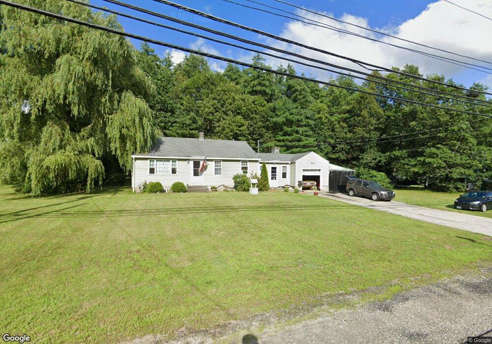
480 Mammoth Rd Londonderry, NH 03053
Estimated Value: $436,000 - $651,000
2
Beds
2
Baths
1,118
Sq Ft
$471/Sq Ft
Est. Value
About This Home
This home is located at 480 Mammoth Rd, Londonderry, NH 03053 and is currently estimated at $526,400, approximately $470 per square foot. 480 Mammoth Rd is a home with nearby schools including North Londonderry Elementary School, Londonderry Middle School, and Londonderry Senior High School.
Ownership History
Date
Name
Owned For
Owner Type
Purchase Details
Closed on
Jul 15, 2009
Sold by
Boyle Michael
Bought by
Greenleaf Michael S and Greenleaf Sandra J
Current Estimated Value
Create a Home Valuation Report for This Property
The Home Valuation Report is an in-depth analysis detailing your home's value as well as a comparison with similar homes in the area
Home Values in the Area
Average Home Value in this Area
Purchase History
| Date | Buyer | Sale Price | Title Company |
|---|---|---|---|
| Greenleaf Michael S | $90,000 | -- |
Source: Public Records
Mortgage History
| Date | Status | Borrower | Loan Amount |
|---|---|---|---|
| Open | Greenleaf Michael S | $147,000 | |
| Closed | Greenleaf Michael S | $125,000 | |
| Closed | Greenleaf Michael S | $120,000 |
Source: Public Records
Tax History Compared to Growth
Tax History
| Year | Tax Paid | Tax Assessment Tax Assessment Total Assessment is a certain percentage of the fair market value that is determined by local assessors to be the total taxable value of land and additions on the property. | Land | Improvement |
|---|---|---|---|---|
| 2024 | $6,325 | $391,900 | $189,900 | $202,000 |
| 2023 | $5,956 | $380,600 | $189,900 | $190,700 |
| 2022 | $5,470 | $296,000 | $142,900 | $153,100 |
| 2021 | $5,440 | $296,000 | $142,900 | $153,100 |
| 2020 | $4,753 | $242,900 | $118,300 | $124,600 |
| 2019 | $4,710 | $242,900 | $118,300 | $124,600 |
| 2018 | $4,284 | $197,700 | $98,700 | $99,000 |
| 2017 | $4,272 | $197,700 | $98,700 | $99,000 |
| 2016 | $4,251 | $197,700 | $98,700 | $99,000 |
| 2015 | $4,156 | $197,700 | $98,700 | $99,000 |
| 2014 | $4,169 | $197,700 | $98,700 | $99,000 |
| 2011 | -- | $194,400 | $98,700 | $95,700 |
Source: Public Records
Map
Nearby Homes
- 28 Barksdale Ave
- 8 Barksdale Ave
- 27 Buckingham Dr
- 17 Welch Rd
- 4 Crestview Cir Unit 119
- 32 Noyes Rd
- 38 Bartley Hill Rd
- 36 Perkins Rd
- 50 Bartley Hill Rd
- 10 Auburn Rd
- 15 Harvey Rd
- 103 Rockingham Rd Unit 1
- 103 Rockingham Rd Unit 2
- 19 Auburn Rd
- 193 Fieldstone Dr
- 193 Fieldstone Dr Unit 193
- 5 Webster Rd
- 118 Fieldstone Dr Unit 118
- 169 Fieldstone Dr
- 75 Rockingham Rd
- 482 Mammoth Rd
- 482 Mammoth Rd Unit B
- 483 Mammoth Rd
- 485 Mammoth Rd
- 478 Mammoth Rd
- 487 Mammoth Rd
- 489 Mammoth Rd
- 1 Leelynn Cir
- 479 Mammoth Rd
- 491 Mammoth Rd Unit 32
- 491 Mammoth Rd Unit 13
- 491 Mammoth Rd Unit 33
- 491 Mammoth Rd Unit 36
- 491 Mammoth Rd Unit 9
- 491 Mammoth Rd Unit 21
- 491 Mammoth Rd Unit 38
- 491 Mammoth Rd Unit 39
- 491 Mammoth Rd Unit 11
- 491 Mammoth Rd Unit 6
- 491 Mammoth Rd Unit 38