480 Philip Ave Staten Island, NY 10312
Huguenot NeighborhoodEstimated Value: $655,000 - $880,000
3
Beds
2
Baths
1,140
Sq Ft
$670/Sq Ft
Est. Value
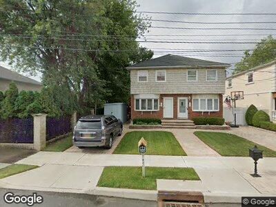
About This Home
This home is located at 480 Philip Ave, Staten Island, NY 10312 and is currently estimated at $764,087, approximately $670 per square foot. 480 Philip Ave is a home located in Richmond County with nearby schools including P.S. 5 - Huguenot, I.S. 007 Elias Bernstein, and Tottenville High School.
Ownership History
Date
Name
Owned For
Owner Type
Purchase Details
Closed on
Nov 6, 2018
Sold by
Peckerman Anna and Peckerman Anna
Bought by
Peckerman Ann and Peckerman Ann
Current Estimated Value
Purchase Details
Closed on
Mar 30, 2000
Sold by
Barbieri James and Barbieri Donna
Bought by
Peckerman Anna and Pozin Boris
Home Financials for this Owner
Home Financials are based on the most recent Mortgage that was taken out on this home.
Original Mortgage
$166,500
Interest Rate
8.21%
Create a Home Valuation Report for This Property
The Home Valuation Report is an in-depth analysis detailing your home's value as well as a comparison with similar homes in the area
Home Values in the Area
Average Home Value in this Area
Purchase History
| Date | Buyer | Sale Price | Title Company |
|---|---|---|---|
| Peckerman Ann | -- | None Available | |
| Peckerman Anna | $236,500 | Washington Title Insurance C |
Source: Public Records
Mortgage History
| Date | Status | Borrower | Loan Amount |
|---|---|---|---|
| Open | Pozin Boris | $10,805 | |
| Open | Pozin Boris | $356,830 | |
| Closed | Peckerman Anna | $166,500 |
Source: Public Records
Tax History Compared to Growth
Tax History
| Year | Tax Paid | Tax Assessment Tax Assessment Total Assessment is a certain percentage of the fair market value that is determined by local assessors to be the total taxable value of land and additions on the property. | Land | Improvement |
|---|---|---|---|---|
| 2024 | $6,088 | $34,320 | $8,189 | $26,131 |
| 2023 | $5,823 | $30,070 | $7,673 | $22,397 |
| 2022 | $5,376 | $31,980 | $8,880 | $23,100 |
| 2021 | $5,478 | $32,820 | $8,880 | $23,940 |
| 2020 | $5,465 | $32,340 | $8,880 | $23,460 |
| 2019 | $5,224 | $32,040 | $8,880 | $23,160 |
| 2018 | $4,810 | $25,058 | $8,115 | $16,943 |
| 2017 | $4,519 | $23,640 | $8,880 | $14,760 |
| 2016 | $4,266 | $22,891 | $8,243 | $14,648 |
| 2015 | $3,913 | $22,680 | $9,840 | $12,840 |
| 2014 | $3,913 | $21,979 | $8,749 | $13,230 |
Source: Public Records
Map
Nearby Homes
- 480 Philip Ave
- 478 Philip Ave
- 474 Philip Ave
- 488 Philip Ave
- 244 Kenwood Ave
- 477 Bertram Ave
- 0 Kenwood Ave
- 477 Philip Ave
- 489 Philip Ave
- 31 Zephyr Ave
- 210 Kenwood Ave
- 460 Philip Ave
- 241 Kenwood Ave
- 41 Zephyr Ave
- 219 Kenwood Ave
- 437 Bertram Ave
- 501 Philip Ave
- 438 Poillon Ave
- 430 Poillon Ave
- 435 Bertram Ave