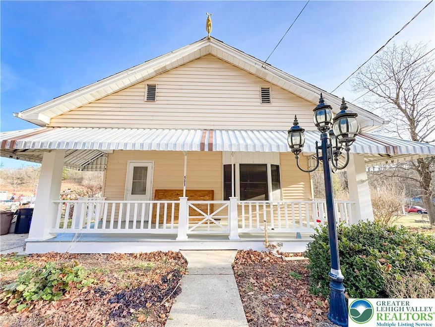


481 Main Rd Lehighton, PA 18235
About This Home
Welcome to 481 Main Rd in Lehighton—a comfortable and well-kept 3-bed, 1-bath home offering a practical layout and inviting atmosphere. The property includes an unfinished basement for storage or projects, a one-car garage, one-car carport, driveway, and an additional parking pad, providing plenty of space and convenience. A usable yard area with a relaxing stream offers room for everyday outdoor enjoyment, hobbies, or relaxation.
This home is ideally situated near a variety of local amenities like Beltzville State Park, the D&L Trail with convenient travel to nearby entertainment and easy access to downtown Lehighton, where local shops, services, and eateries are at your convenience.
With a versatile layout, useful storage areas, and convenient proximity to shopping, dining, and recreation, this property offers a comfortable place to settle into a home that fits many lifestyles.
Home Details
Home Type
- Single Family
Est. Annual Taxes
- $3,235
Year Built
- Built in 1940
Parking
- 2 Car Garage
- Carport
- Parking Pad
- Driveway
Home Design
- 1,056 Sq Ft Home
Kitchen
- Microwave
- Dishwasher
Bedrooms and Bathrooms
- 3 Bedrooms
- 1 Full Bathroom
Additional Features
- Washer Hookup
- 0.52 Acre Lot
- Heating Available
- Basement
Community Details
- No Pets Allowed
Map
Source: Greater Lehigh Valley REALTORS®
MLS Number: 768356
APN: 70F-11-35
Disclaimer: Certain information contained herein is derived from information provided by parties other than Homes.com. All information provided is deemed reliable, but is not guaranteed to be accurate and should be independently verified.
![]() IDX information is provided exclusively for personal, non-commercial use, and may not be used for any purpose other than to identify prospective properties consumers may be interested in purchasing.
IDX information is provided exclusively for personal, non-commercial use, and may not be used for any purpose other than to identify prospective properties consumers may be interested in purchasing.
Information is deemed reliable but not guaranteed.
- 0 Fairyland Rd Unit PM-136987
- 361 Court St Unit REAR
- 361 Court St
- 201 Fairview St
- 142 Bankway St
- 8 Lentz Ave
- 230 S 2nd St
- 236 S 2nd St
- 12 2nd Ave
- 231 Coal St
- 196 S 3rd St
- 193 S 4th St
- 193 S 4th St Unit 191-193
- 117 N 4th St
- 215 N 4th St
- 230 Carbon St
- 600 N Harrity Rd
- 161 Reber St
- 344 Ochre St
- 522 Iron St
- 207 N 1st St Unit A
- 201 S 2nd St Unit C
- 201 S 2nd St Unit B
- 201 S 2nd St Unit A
- 120 S 2nd St Unit A
- 211 South St Unit 7
- 227 South St Unit 229
- 1500 Rock St Unit 2
- 1500 Rock St
- 1500 Rock St Unit 1
- 404 Mahoning St Unit 2
- 406 Mahoning St Unit 2
- 406 Mahoning St
- 381-383-383 S 3rd St Unit 381. Unit-3
- 318 N 4th St
- 318 N 4th St
- 353 N 6th St Unit 355
- 110 S 7th St
- 226 Fern St
- 241 Center Ave Unit 241
