Estimated Value: $227,979 - $452,000
3
Beds
1
Bath
840
Sq Ft
$373/Sq Ft
Est. Value
About This Home
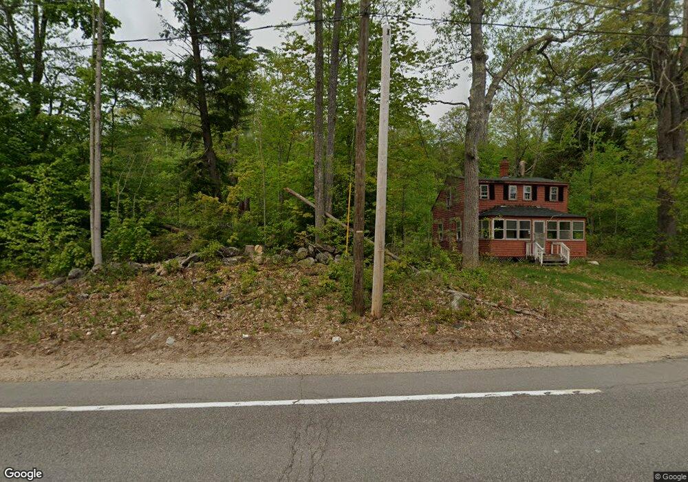
This home is located at 481 Wakefield Rd, Union, NH 03887 and is currently estimated at $313,495, approximately $373 per square foot. 481 Wakefield Rd is a home located in Carroll County with nearby schools including Paul Elementary School.
Ownership History
Date
Name
Owned For
Owner Type
Purchase Details
Closed on
Jun 26, 2018
Sold by
Bank Of America Na
Bought by
Berky Timothy J
Current Estimated Value
Purchase Details
Closed on
May 5, 2017
Sold by
Fowler Joseph S
Bought by
Bank Of America Na
Purchase Details
Closed on
Sep 21, 2004
Sold by
Kinville Randy M and Kinville Constance W
Bought by
Fowler Amanda J and Fowler Joseph S
Home Financials for this Owner
Home Financials are based on the most recent Mortgage that was taken out on this home.
Original Mortgage
$115,090
Interest Rate
6.02%
Mortgage Type
Purchase Money Mortgage
Create a Home Valuation Report for This Property
The Home Valuation Report is an in-depth analysis detailing your home's value as well as a comparison with similar homes in the area
Home Values in the Area
Average Home Value in this Area
Purchase History
| Date | Buyer | Sale Price | Title Company |
|---|---|---|---|
| Berky Timothy J | $40,106 | -- | |
| Bank Of America Na | $197,601 | -- | |
| Fowler Amanda J | $120,000 | -- |
Source: Public Records
Mortgage History
| Date | Status | Borrower | Loan Amount |
|---|---|---|---|
| Previous Owner | Fowler Amanda J | $115,090 |
Source: Public Records
Tax History
| Year | Tax Paid | Tax Assessment Tax Assessment Total Assessment is a certain percentage of the fair market value that is determined by local assessors to be the total taxable value of land and additions on the property. | Land | Improvement |
|---|---|---|---|---|
| 2025 | $1,555 | $178,500 | $80,800 | $97,700 |
| 2024 | $1,461 | $194,300 | $80,800 | $113,500 |
| 2023 | $1,331 | $194,300 | $80,800 | $113,500 |
| 2022 | $1,216 | $99,300 | $34,300 | $65,000 |
| 2021 | $1,225 | $99,300 | $34,300 | $65,000 |
| 2020 | $1,229 | $99,300 | $34,300 | $65,000 |
| 2019 | $1,337 | $107,200 | $34,300 | $72,900 |
| 2018 | $1,207 | $107,200 | $34,300 | $72,900 |
| 2017 | $1,152 | $91,100 | $34,100 | $57,000 |
| 2016 | $1,179 | $91,100 | $34,100 | $57,000 |
| 2015 | $1,190 | $91,100 | $34,100 | $57,000 |
| 2014 | $1,161 | $91,100 | $34,100 | $57,000 |
| 2013 | $1,095 | $89,200 | $34,100 | $55,100 |
Source: Public Records
Map
Nearby Homes
- lot 20 Access Rd
- Lot 19 Access Rd
- lot 15 Access Rd
- lot 14 Access Rd
- 169 Whippoorwill Rd
- 156 Access Rd
- 266 Access Rd
- 1457 Wakefield Rd
- 46-2 & 47 New Hampshire 153
- 13 Mountain View Dr
- 202 Rines Rd
- 39 Rines Rd
- 21 Saint Anthonys Rd
- 2106 Wakefield Rd
- 10 New Durham Rd
- 50 Kings Hwy
- 0 White Mountain Hwy Unit 5033185
- 564 White Mountain Hwy
- 13 Cattail Ln
- 35 Highland Ave
- 453 Wakefield Rd
- 27 Old Settlers Ln
- 468 Wakefield Rd
- 512 Wakefield Rd
- 417 Wakefield Rd
- 518 Wakefield Rd
- 488 Wakefield Rd
- 42 Old Settlers Ln
- 2 Access Rd
- 0 Access Rd
- 450 Wakefield Rd
- 61 Old Settlers Ln
- 552 Wakefield Rd
- 414 Wakefield Rd
- * Wakefield Rd
- 22 Access Rd Unit 22
- Lot 22 & 22-1 Access Rd
- 66 Old Settlers Ln
- 0 Access Unit 117A, 117B, 119A, 11
- Lot 31 Access Rd Unit 31
Your Personal Tour Guide
Ask me questions while you tour the home.